
List of Sites of Special Scientific Interest on the Isle of Wight facts for kids

The Isle of Wight is an island located just three miles off the south coast of England in the English Channel. Even though it's a smaller county with about 140,000 people, it's super important for nature! This is because it has many special places called Sites of Special Scientific Interest (SSSIs).
Contents
What are Sites of Special Scientific Interest?
SSSIs are special areas chosen because they have amazing plants, animals, or unique geological features. Think of them as nature's treasures! These sites are protected by law to make sure their special qualities are kept safe for the future.
Who Protects These Special Places?
In England, the job of finding and protecting SSSIs belongs to an organization called Natural England. They decide which places are important enough to be an SSSI. Natural England was created in 2006. Before that, another group called English Nature did this important work.
Why is the Isle of Wight So Special?
The Isle of Wight has a very interesting geology, which is the study of rocks and how the Earth is made. It has a ridge of chalk downland (hills made of chalk) running right through the middle. Along the coast, there are incredible fossil beds from ancient times, like the Cretaceous period and the early Tertiary period. These are periods when dinosaurs and early mammals lived!
This mix of different rocks and coastal areas creates many unique natural homes, called habitats. These include:
- Chalk grassland: Grassy areas on chalk hills, home to special wildflowers and insects.
- Neutral meadows: Fields with a balanced soil type, perfect for many different plants.
- Broad-leaved woodland: Forests with trees that lose their leaves in autumn, like oak and beech.
All these different habitats, along with the island's coastal location, make the Isle of Wight a fantastic place for wildlife and important geological discoveries.
How Many SSSIs are on the Isle of Wight?
As of 2008, there were 41 Sites of Special Scientific Interest on the Isle of Wight. These sites are protected for different reasons:
- 26 sites are special because of their amazing plants and animals (biological interest).
- 4 sites are special because of their unique rocks and landforms (geological interest).
- 11 sites are special for both their biology and their geology!
These protected areas help to make sure that the Isle of Wight's natural beauty and important scientific features are preserved for everyone to enjoy.
Images for kids
-
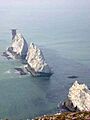
The Needles, part of Headon Warren And West High Down SSSI
