
List of lighthouses in Panama facts for kids
Lighthouses are tall towers with bright lights that help ships find their way safely at sea. They are especially important in places like Panama, which has the famous Panama Canal. This canal is a busy waterway connecting the Atlantic and Pacific Oceans, so lighthouses are vital for guiding ships through its waters and along the coastlines.
Contents
What is a Lighthouse?
A lighthouse is like a helpful giant standing by the sea. Its main job is to shine a powerful light that sailors can see from far away. This light warns them about dangerous areas, like rocky shores or shallow waters. Lighthouses also guide ships into safe harbors and show them the right path to follow.
Each lighthouse has a special "light characteristic," which is like its unique signal. This could be a steady light, a flashing light, or a light that goes dark for a moment. This pattern helps sailors know exactly which lighthouse they are seeing, even in the dark or bad weather.
The "focal height" of a lighthouse tells you how high its light is above the water. A higher light can be seen from further away. The "range" tells you how many nautical miles (a unit of distance used at sea) the light can be seen on a clear night.
Important Lighthouses in Panama
Panama has many lighthouses along its long coastlines and near the Panama Canal. Here are some of them:
Lighthouses of the Panama Canal
The Panama Canal is a very important shipping route. Lighthouses here help guide ships safely through the canal's entrance and locks.
- Atlantic Entrance Range Middle Lighthouse: Built in 1914, this lighthouse is located in Gatún. It helps guide ships entering the canal from the Atlantic side.
- Atlantic Entrance Range Rear Lighthouse: Also built in 1914 in Gatún, this lighthouse works with the Middle Lighthouse to create a "range." When a ship lines up these two lights, it knows it's on the correct path.
- Gatún Northbound Rear Lighthouse: This lighthouse, built in 1914, also helps guide ships through the Gatún area of the canal.
- Pacific Entrance Range Front Lighthouse: Built more recently in 2010, this lighthouse is near Balboa. It guides ships entering the canal from the Pacific Ocean.
- Toro Point Lighthouse: This historic lighthouse was built in 1893 at Toro Point, near Limon Bay. It has been guiding ships for over a century.
_(14781151162).jpg)
Coastal Lighthouses
Many lighthouses are found along Panama's Pacific and Atlantic coasts, helping ships navigate the open sea.
- Isla Grande Lighthouse: This lighthouse, built in 1894, is on Isla Grande on the Caribbean coast. It's one of Panama's older lighthouses.
- Isla Iguana Lighthouse: Located in the Isla Iguana Wildlife Refuge, this lighthouse helps protect ships near this important natural area.

- Isla Jicarita Lighthouse: Found in Veraguas Province, this lighthouse has a very high light, making it visible from far away.
- Punta Mariato Lighthouse: This lighthouse is at Punta Mariato, the southernmost point of mainland Panama. Its light can be seen for a long distance.
- Flamenco Island Lighthouse: Built in the 1920s, this lighthouse is near El Chorrillo and guides ships approaching Panama City from the Pacific.
- Isla Boná Lighthouse: Located in Panamá Oeste Province, this lighthouse helps guide ships along the Pacific coast.
- Isla Villa Lighthouse: This lighthouse is in Los Santos Province.
- Morro de Puercos Lighthouse: Also in Los Santos Province, this lighthouse helps ships avoid dangers along the coast.
- Punta Mala Lighthouse: This lighthouse is important for guiding ships around the "Bad Point" (Punta Mala) in Los Santos Province.
Images for kids
-
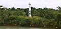
Atlantic Entrance Range Middle Lighthouse.
-
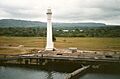
Gatún Northbound Rear Lighthouse.


See also
- Lists of lighthouses and lightvessels
 In Spanish: Anexo:Faros de Panamá para niños
