
List of local nature reserves in Lincolnshire facts for kids
Lincolnshire is a large county in England, located on the eastern side of the country. It's known for its long coastline along the North Sea and the Humber estuary. The county is split into different parts for how it's managed. There are two main areas called North Lincolnshire and North East Lincolnshire, which are like their own mini-counties. Then there's the main part of Lincolnshire, which is managed by the Lincolnshire County Council. This main part is divided into six smaller areas, including places like Boston, Lincoln, and Sleaford.
Lincolnshire is the fourth biggest county in England by size. However, it doesn't have as many people as some other large counties. About 714,800 people live here, making it the 14th most populated county.
Contents
What Are Local Nature Reserves?
Local nature reserves, or LNRs, are special places protected by local councils. They are set up under a law from 1949 called the National Parks and Access to the Countryside Act 1949. These reserves are important because they have unique plants, animals, or interesting geological features.
Local councils must have control over these sites, either by owning them, renting them, or having a special agreement with the owner. This allows them to look after the reserves properly. Councils can also create special rules, called bye-laws, to help manage and protect these natural areas. As of January 2018, Lincolnshire has 32 of these important Local Nature Reserves.
Exploring Lincolnshire's Nature Reserves
Lincolnshire is home to many Local Nature Reserves, each offering a special place for wildlife and nature. These areas help protect different habitats and the creatures that live there. Here are some of the notable LNRs in the county:
North Lincolnshire Reserves
North Lincolnshire has several important nature reserves. These areas are managed by the North Lincolnshire Council to protect local wildlife.
Atkinsons Warren
Atkinsons Warren is a large reserve covering 32.8 hectares near Scunthorpe. It's a great place to explore nature.

Brumby Wood
Also in Scunthorpe, Brumby Wood is 21.84 hectares. It's a woodland area that provides a home for many different species.

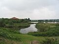
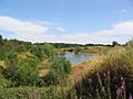
Far Ings
Near Barton-upon-Humber, Far Ings is 15.15 hectares. This reserve is known for its wetland habitats.

Owston Ferry Castle
This reserve is unique because it includes the ruins of Owston Ferry Castle. It's a smaller site, only 0.90 hectares, but combines history with nature.

Water's Edge Country Park
Water's Edge Country Park is a large reserve of 41.46 hectares in Barton-upon-Humber. It offers beautiful views and habitats near the water.

North East Lincolnshire Reserves
North East Lincolnshire also manages its own set of Local Nature Reserves, focusing on the natural beauty of its region.
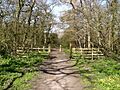
Bradley and Dixon Woods
South of Grimsby, Bradley and Dixon Woods covers 41.77 hectares. It's a significant woodland area.

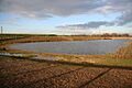
Cleethorpes Country Park
Located between Cleethorpes and Humberston, Cleethorpes Country Park is a large area of 62.01 hectares. It's a popular spot for outdoor activities and nature watching.

Weelsby Woods Park
Weelsby Woods Park in Grimsby is 34.7 hectares. It's another important green space for the area.

Lincolnshire County Council Reserves
The main Lincolnshire County Council looks after many reserves across the wider county.
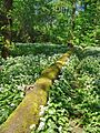
Lollycocks Field
Lollycocks Field is a smaller reserve of 2.15 hectares in Sleaford. It's a local green space for the community.
.jpg)
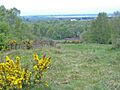
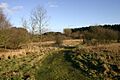
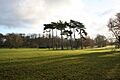
Snipe Dales
One of the larger reserves, Snipe Dales is 82.16 hectares near Hagworthingham. It's a beautiful area with diverse landscapes.

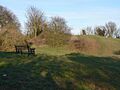
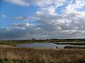
Stanton's Pit
Stanton's Pit near Little Bytham is 8.05 hectares. It's a valuable site for local wildlife.

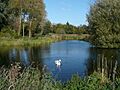
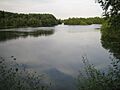
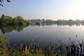
Swanholme Lakes
In Lincoln, Swanholme Lakes covers 52.51 hectares. It's a significant natural area within the city.

Whisby Nature Park
Whisby Nature Park is one of the largest reserves, at 107.57 hectares, near Thorpe-on-the-Hill. It's a very popular place for nature lovers.

Images for kids
-
Atkinson's Warren
-
Entrance to Bradley Woods
-
Brumby Wood
-
The lake at Cleethorpes Country Park
-
Far Ings Nature Reserve
-
Lollycocks Pond, Lollycocks Field
-
Ruins of Owston Ferry Castle
-
Snipe Dales
-
Stanton's Pit
-
Swanholme Lakes
-
Waters' Edge Country Park, Barton Upon Humber
-
Weelsby Woods
-
Whisby Nature Park
