List of mountain passes in Montana (A–L) facts for kids
Montana is a state known for its amazing mountains. All across this beautiful state, you can find special places called mountain passes. A mountain pass is like a natural pathway or a lower spot between two mountains or ridges. Imagine a giant wall of mountains; a pass is a door or a low window through that wall. Montana has at least 290 named mountain passes! These passes have been important for travelers, animals, and even history for a very long time.
Contents
What is a Mountain Pass?
A mountain pass is a low point in a mountain range. It's usually the easiest way to cross from one side of the mountains to the other. Think of it as a natural bridge over a valley, or a dip that connects two higher areas. People have used these natural pathways for thousands of years. They are often formed by rivers, glaciers, or even by the wind and rain wearing down the rock over time.
Why are Mountain Passes Important?
Mountain passes are super important for many reasons:
- Travel: They make it much easier to travel across mountains. Without passes, people would have to climb over tall peaks, which is very hard and dangerous.
- Trade: In the past, passes were vital for trading goods between different communities.
- Exploration: Famous explorers like Lewis and Clark used passes to cross the American West.
- Wildlife: Animals also use passes to move between different areas, especially when looking for food or new habitats.
- Roads and Railways: Today, many roads and train tracks are built through mountain passes. This helps connect towns and cities.
Famous Mountain Passes in Montana
Montana has many passes, each with its own story and importance. Here are a few examples:
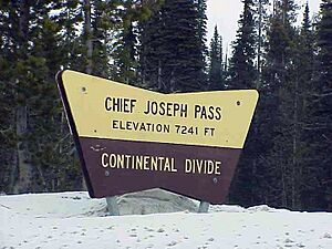
Chief Joseph Pass
Chief Joseph Pass is a famous pass located in Beaverhead County. It sits at an elevation of about 7,251 feet (2,210 meters) above sea level. This pass is named after Chief Joseph of the Nez Perce tribe. He led his people through this area during their historic journey in 1877. It's a place with a lot of history!
Lolo Pass
Lolo Pass is another very important pass. It's on the border between Montana and Idaho, in Missoula County. This pass is about 5,223 feet (1,592 meters) high. It was also used by the Lewis and Clark Expedition in 1805 and 1806. Today, a major highway, U.S. Route 12, goes through Lolo Pass, making it a busy route for travelers.
Bozeman Pass
Bozeman Pass is in Gallatin County, Montana. It has an elevation of 5,702 feet (1,738 meters). This pass is a key gateway to the city of Bozeman and the surrounding areas. It's an important route for both cars and trains, connecting eastern and western Montana.
Logan Pass
Found in Glacier County, Logan Pass is one of the most stunning passes in Glacier National Park. It's quite high, at 6,653 feet (2,028 meters). The famous Going-to-the-Sun Road crosses this pass, offering incredible views of the park's glaciers and wildflowers. It's a popular spot for tourists and hikers.
How Passes are Measured
When we talk about mountain passes, we often mention their elevation and coordinates.
- Elevation: This is how high a pass is above sea level. It's usually measured in feet or meters. Higher passes mean you're really up in the mountains!
- Coordinates: These are like an address on a map, using numbers to show the exact location of the pass. They use latitude (how far north or south) and longitude (how far east or west). For example, `45|41|05|N|113|55|59|W` for Chief Joseph Pass tells us its precise spot on Earth.
Exploring Montana's Passes
Montana's many mountain passes are not just points on a map. They are important parts of the state's geography, history, and natural beauty. Whether you're driving through one on a family trip or learning about their role in history, these passes offer a glimpse into the wild and wonderful world of Montana's mountains.
See also
- List of mountain passes in Montana (M–Z)
- List of mountains in Montana
- List of mountain ranges in Montana
 | Tommie Smith |
 | Simone Manuel |
 | Shani Davis |
 | Simone Biles |
 | Alice Coachman |


