
List of places on the Victorian Heritage Register in the Shire of Colac Otway facts for kids
This page lists some really cool and important places in the Shire of Colac Otway in Victoria, Australia. These places are so special that they are listed on the Victorian Heritage Register. This register is like a special list of buildings, sites, and objects that are important to Victoria's history and culture. It's looked after by the Heritage Council of Victoria.
As of 2020, there are 11 amazing places in the Shire of Colac Otway that are on this register. Let's explore some of them!
Contents
Awesome Historic Places in Colac Otway
Eurack Avenue of Honour
The Eurack Avenue of Honour is a special row of trees planted along Eurack Road. It was created in 1916 to remember people from the area who served in the war. It's a beautiful and meaningful tribute.
Cape Otway Lighthouse
,_Cape_Otway_Lighthouse_--_2019_--_1226.jpg)
The Cape Otway Lighthouse is one of Australia's most famous lighthouses. It was built a very long time ago, between 1846 and 1848. This lighthouse stands tall on the coast at Cape Otway and has helped guide ships safely past the dangerous coastline for many years. It's a really important part of maritime history.
Colac Botanic Gardens
The Colac Botanic Gardens are beautiful gardens located at 1-5 Fyans Street in Colac. They were first designed around 1868. These gardens are a lovely place to visit and show how people enjoyed nature and gardening over a hundred years ago.
Adam Rea's Store
Adam Rea's Store is an old building at 1 Murray Street in Colac. It was built in 1868. This store is a reminder of how shops used to look and operate in the past, playing an important role in the local community.
Great Ocean Road

The Great Ocean Road is a world-famous road that stretches through the Shire of Colac Otway, from Separation Creek to past Yuulong. Construction on this incredible road began in 1877. It's known for its stunning coastal views and was built by returned soldiers after World War I, making it a living memorial.
Henry's No. 1 Mill
Henry's No. 1 Mill is an old timber mill located on West Barwon Track near Barramunga. It was built in 1904. This mill shows how timber was processed in the early 20th century, which was a big industry in this area.
Henry's Tramway Tunnel
Close to Henry's No. 1 Mill, you'll find Henry's Tramway Tunnel, built in 1911. This tunnel was part of a tramway system used to transport timber from the forests to the mill. It's a cool example of old engineering used for logging.
Knott's No. 3 Mill
Knott's No. 3 Mill is another historic timber mill, found in the Otway State Forest near Wyelangta. It was built in 1922. Like Henry's Mill, it tells the story of the region's timber industry.
Mount Hesse Station
Mount Hesse Station is a large historic property at 155-159 Mount Hesse Estate Road in Ombersley. The main buildings were constructed in the 1840s. This station is one of the oldest and most important pastoral (farming) properties in Victoria.
Pirron Yallock Railway Station
The Pirron Yallock railway station is located at 2 Station Road in Pirron Yallock. It was built in 1894. This old railway station reminds us of the early days of train travel and how important railways were for connecting towns and transporting goods.
Tarndwarncoort
Tarndwarncoort is a historic homestead at 37 Roseneath Road in Warncoort. The main parts of the house were built between 1848 and 1849. It's one of the oldest surviving homes in the region and gives us a peek into what life was like for early settlers.
Images for kids
-
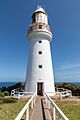
The historic Cape Otway Lighthouse.
-
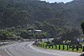
A beautiful view of the Great Ocean Road.
