
List of prehistoric scheduled monuments in Gwynedd (former Caernarvonshire) facts for kids
Gwynedd is a big, beautiful county in North Wales. It's home to the tall mountains of Snowdonia National Park and the rolling hills and farms of the Llŷn peninsula. These areas used to be part of a historic county called Caernarvonshire. The southern part of Gwynedd has softer hills and pretty coastlines, which were once part of Merionethshire.
Gwynedd is the second-largest county in Wales. It has a huge number of ancient sites, called scheduled monuments – 497 in total! To make it easier to understand, these sites are split into three groups. This article will focus on the 194 prehistoric sites found in the historic area of Caernarvonshire. There are also 171 prehistoric sites in historic Merionethshire, and 132 Roman to modern sites across all of Gwynedd.
One of the oldest sites discovered is a stone axe factory. Across Gwynedd, there are 139 burial sites. These include different types of ancient graves like chambered tombs, cairns, mounds, and barrows. They date back to the Neolithic (New Stone Age), Bronze Age, and Iron Age. Many sites, about 167, are 'domestic' – meaning they were places where people lived. Most of these are Iron Age hut circles and enclosures. There are also 47 defensive sites, like hillforts and promontory forts, also from the Iron Age.
Gwynedd is a modern local authority that covers most of these two historic areas. In 1974, it even joined with Anglesey, and the combined area was called Gwynedd. However, since 1996, Anglesey has been its own separate county again.
Scheduled monuments are very important. They are protected by law, which means it's illegal to dig up the ground or mess with any old remains. These lists are put together by Cadw Welsh Historic Monuments, an agency that looks after Wales's history. They also get help from RCAHMW and Gwynedd Archaeological Trust.
Contents
Discovering Prehistoric Sites in Caernarvonshire
This part of Gwynedd, once known as Caernarvonshire, is full of amazing prehistoric sites. These are places where people lived, worked, and were buried thousands of years ago. Exploring them helps us understand how ancient people lived in Wales.
Ancient Homes: Hut Circles and Settlements
Many of the prehistoric sites here are 'hut circles' or 'hut circle settlements'. These were the homes of ancient people. A hut circle is the circular stone foundation of a round house. Sometimes, these huts were grouped together to form a settlement, like a small village. Some settlements were enclosed, meaning they had walls or ditches around them for protection.
For example, near Aber, you can find the Enclosed Hut Circle Settlement South-East of Bod Silin. This shows how people lived together in a protected area. In Beddgelert, there's the Cwm Dyli Ancient Village, another example of an unenclosed hut circle settlement. These sites give us clues about daily life long ago.
Burial Grounds: Cairns, Barrows, and Tombs
Another common type of prehistoric site is for burials. People in the past buried their dead in special ways.
- Cairns are piles of stones, often built over graves. You can find many round cairns, like the Carnedd y Ddelw Cairn near Aber.
- Barrows are mounds of earth built over burial sites. The Mynydd Enlli Round Barrow on Bardsey Island is an example.
- Chambered tombs are ancient stone structures, often with a room or chamber inside, used for burying people. The Rhiw Burial Chambers in Aberdaron are a great example of a chambered long cairn.
These burial sites tell us about the beliefs and customs of ancient communities.
Defensive Sites: Hillforts and Promontory Forts
To protect themselves, ancient people built strong defensive sites.
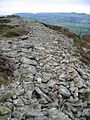
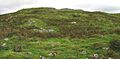
- Hillforts are large, fortified settlements built on hilltops. They often have earthworks or stone walls for defense. Garn Boduan in Buan and Tre'r Ceiri in Llanaelhaearn are famous hillforts in this area. These were important places for communities to gather and defend themselves.
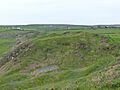
- Promontory forts are similar but built on a piece of land that sticks out into the sea or a river, using the natural landscape for defense. Dinas Dinlle Camp in Llandwrog is a coastal promontory fort.
These forts show how important safety and community defense were thousands of years ago.
Other Interesting Prehistoric Finds
Beyond homes and defenses, there are other unique prehistoric sites:
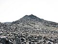
- Stone Axe Factories: The Mynydd Rhiw Stone Axe Factory in Botwnnog is a very special site. It's where ancient people made stone axes, which were essential tools for survival.
- Standing Stones: These are tall, upright stones, often placed for unknown ritual or ceremonial reasons. The Graianog Standing Stone in Clynnog is one such example.
- Burnt Mounds: These are heaps of heat-cracked stones, often found near water. They are thought to be ancient cooking sites or places for heating water. There's a Burnt Mound East of Pen-y-Gaer in Llanaelhaearn.
These different types of sites paint a picture of a busy and resourceful prehistoric society in Gwynedd.
Images for kids
-
The impressive Garn Boduan hillfort.
-
Pen Dinas Camp hillfort, seen from the west.
-
Pared Mawr Camp, a coastal promontory fort.
-
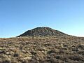
The ancient Carnedd Fach cairn.
-
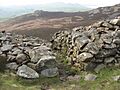
The main entrance to Tre'r Ceiri hillfort.
-
Walking towards the Carnguwch Cairn.
-
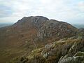
Moel y Gest mountain, home to an ancient hillfort.


See also
