Moel y Gest facts for kids
Quick facts for kids Moel-y-Gest |
|
|---|---|
 |
|
| Highest point | |
| Elevation | 263 m (863 ft) |
| Prominence | 236 m (774 ft) |
| Listing | Marilyn |
| Geography | |
| Location | Snowdonia |
| OS grid | SH549388 |
| Topo map | Ordnance Survey Explorer 18 |
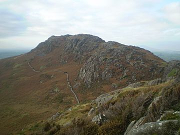
Moel y Gest is a hill in North Wales, standing at 263 m (863 ft) (about 863 feet) tall. It is located west of the town of Porthmadog. This hill is very rocky and stands out because the land around it is much lower. Because of this, it is known as a Marilyn. From the top of Moel y Gest, you can see amazing views. These include the Llŷn Peninsula, the Rhinogydd mountains, Moelwynion, Moel Hebog, and even Snowdon.
Climbing Moel y Gest
You can climb Moel y Gest from the south side. The journey usually starts from a small road that goes from Porthmadog towards Black Rock Sands. The path first crosses grassy fields. After that, you will reach steeper parts of the hill. These areas have plants like gorse and bracken.
There are many small paths that connect on the slopes. The very top of the hill is rocky. It has rough grass and large stones. At the summit, you will find a pile of stones called a cairn. There is also a path that runs along the ridge of the hill. Other ways to climb Moel y Gest exist from the northeast and north. However, these routes do not have a main path.
Ancient Sites on the Hill
At the very top of Moel y Gest, there are the remains of an ancient hillfort. A hillfort is a type of fort built on a hill. This fort looks a bit like some old forts found in Scotland. These Scottish forts are sometimes called "nuclear forts." They have a special design with loops of walls and a main strong area called a "citadel."
This hillfort on Moel y Gest has some unique features. For most of its edge, the walls follow the natural shape of the hill. This made it easy to defend. But, in the northwestern part, where the entrance was, the wall is set back from the edge. This might have made it harder to see enemies coming. The walls of the fort contain many white, shiny quartz stones. This makes some people think the fort might have been important for religious reasons, not just for fighting.
There are also the remains of a round hut on the northern side of the hill. This hut is found at about 500 ft (150 m) (152 meters) up the slope. It has an entrance on its southwestern side. The hut is about 12 ft (3.7 m) (3.7 meters) across. Its walls are about 2.5 ft (0.8 m) (0.76 meters) thick and 1 ft (0.3 m) (0.3 meters) high.
 | George Robert Carruthers |
 | Patricia Bath |
 | Jan Ernst Matzeliger |
 | Alexander Miles |

