Littenseradiel facts for kids
Quick facts for kids
Littenseradiel
Littenseradeel
|
|||
|---|---|---|---|

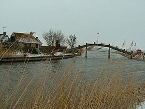
Canal through Wjelsryp
|
|||
|
|||

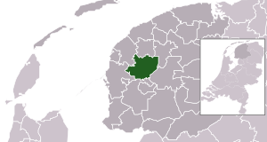
Location in Friesland
|
|||
| Country | Netherlands | ||
| Province | Friesland | ||
| Established | 1 January 1984 | ||
| Government | |||
| • Body | Municipal council | ||
| Area | |||
| • Total | 132.64 km2 (51.21 sq mi) | ||
| • Land | 130.75 km2 (50.48 sq mi) | ||
| • Water | 1.89 km2 (0.73 sq mi) | ||
| Elevation | 1 m (3 ft) | ||
| Population
(May 2014)
|
|||
| • Total | 10,900 | ||
| • Density | 83/km2 (210/sq mi) | ||
| Time zone | UTC+1 (CET) | ||
| • Summer (DST) | UTC+2 (CEST) | ||
| Postcode |
Parts of 8000 and 9000 range
|
||
| Area code | 0515, 0517, 058 | ||
Littenseradiel was a special area in the northern Netherlands. It was like a small local government area, called a municipality. In Dutch, it was known as Littenseradeel.
This municipality was created on January 1, 1984. It was formed by joining two older municipalities: Baarderadeel and Hennaarderadeel. Littenseradiel existed for many years. However, on January 1, 2018, it was officially closed down. Its land was then divided among three other municipalities. These new areas are Waadhoeke, Leeuwarden, and Súdwest-Fryslân.
Villages and Towns
Littenseradiel was made up of many small villages and towns. These communities were part of the municipality. Each one had its own unique character.
Here are some of the villages that were once part of Littenseradiel:
- Baaium
- Baard
- Bears
- Boazum
- Britswert
- Easterlittens
- Easterwierrum
- Hidaard
- Hilaard
- Hinnaard
- Húns
- Iens
- Itens
- Jellum
- Jorwert
- Kûbaard
- Leons
- Lytsewierrum
- Mantgum
- Reahûs
- Rien
- Spannum
- Waaksens
- Weidum
- Winsum
- Wiuwert
- Wjelsryp
- Wommels
Understanding the Landscape
The area of Littenseradiel had a typical Dutch landscape. It featured flat lands and many waterways. These waterways, like canals, were important for transport and farming.
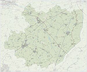
This map shows how the land looked in June 2015. It helps us understand the geography of the former municipality.
See also
 In Spanish: Littenseradiel para niños
 | Selma Burke |
 | Pauline Powell Burns |
 | Frederick J. Brown |
 | Robert Blackburn |


