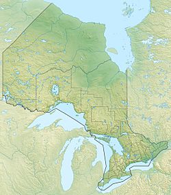
Little Bull Lake (Algoma District) facts for kids
Quick facts for kids Little Bull Lake |
|
|---|---|
| Location | Algoma District, Ontario |
| Coordinates | 46°26′18″N 82°12′49″W / 46.43833°N 82.21361°W |
| Primary inflows | Unnamed creek from Bull Lake |
| Primary outflows | Unnamed creek to Burnett Lake |
| Basin countries | Canada |
| Max. length | 1.1 km (0.68 mi) |
| Max. width | 0.31 km (0.19 mi) |
| Surface elevation | 352 m (1,155 ft) |
Little Bull Lake is a small lake located in the Algoma District of Ontario, Canada. It is a natural freshwater lake, part of a larger system of waterways in the region.
Contents
Exploring Little Bull Lake
Little Bull Lake is about 1.1 kilometres (0.7 mi) long and 0.31 kilometres (0.2 mi) wide. It sits at an elevation of 352 metres (1,155 ft) above sea level. This means it is quite high up compared to the ocean.
Where Does the Water Come From?
The main water source for Little Bull Lake is a small creek. This creek flows into Little Bull Lake from a nearby body of water called Bull Lake.
Where Does the Water Go?
Water from Little Bull Lake flows out through another unnamed creek. This creek leads to Burnett Lake. From Burnett Lake, the water continues its journey through Low Creek. Eventually, it reaches the West River aux Sables. This river is a branch of the larger River aux Sables.
Location and Nearby Areas
Little Bull Lake is located in a natural, mostly undeveloped area. It is about 28 kilometres (17 mi) north of the community of Massey. Massey is a small town where the River aux Sables meets the Spanish River. This area is known for its beautiful lakes and forests.
 | Delilah Pierce |
 | Gordon Parks |
 | Augusta Savage |
 | Charles Ethan Porter |


