
Little Cacapon River facts for kids

The Little Cacapon River is a river in Hampshire County, West Virginia. It's about 25 miles (40 kilometers) long. This river flows freely and eventually joins the Potomac River. From there, its water travels to the Chesapeake Bay and then to the Atlantic Ocean.
The Little Cacapon River flows into the Potomac River near a small community also called Little Cacapon. For most of its journey, the Little Cacapon is a shallow stream, meaning it's not deep enough for boats. In the past, people sometimes called it "Little Cacapehon" or "Little Capecaphon." The name is pronounced "kə-KAY-pən" or "KAY-pən."

The Little Cacapon River starts when two smaller streams, the North Fork Little Cacapon and the South Fork Little Cacapon, meet. This happens near Frenchburg, right after they both pass under U.S. Route 50. From Frenchburg, the river flows north. It runs between Town Hill on its west side and Little Cacapon Mountain on its east side.
As the river flows, other smaller streams join it. Shawan Run flows in near Barnes Mill. A bit further north, Three Churches Run also adds its water to the river. Near Higginsville, Crooked Run joins the Little Cacapon. The river then continues northeast, passing by the community of Creekvale. Finally, after flowing under the Baltimore and Ohio Railroad, the Little Cacapon River empties into the Potomac River.
Contents
Exploring the North Fork Little Cacapon River
The North Fork is one of the two main streams that form the Little Cacapon River. It's about 9.3 miles (15 kilometers) long. This fork begins in a valley between Piney Mountain and Stony Mountain. It flows northeast along Grassy Lick Road. As it continues, South Branch Mountain is to its west. The North Fork then meets U.S. Route 50 near Shanks. After that, it joins with Camp Run and flows under US Route 50 at Frenchburg. Here, it meets the South Fork to create the main Little Cacapon River.
Exploring the South Fork Little Cacapon River
The South Fork is the other important stream that helps form the Little Cacapon River. It's about 8.4 miles (13.5 kilometers) long. This fork starts in a valley on Stony Mountain, between the towns of Kirby and Ruckman. From its beginning, the South Fork flows northeast towards Bell Hollow, where it also meets U.S. Route 50. It then turns north through Frye's Flat towards Frenchburg. After passing under US Route 50, it immediately joins the North Fork. This meeting point is where the Little Cacapon River officially begins.
Smaller Streams Joining the River
Many smaller streams, called tributaries, flow into the Little Cacapon River, adding to its water. Here are some of them, listed from south to north:
- South Fork Little Cacapon River
- Bell Hollow Run
- North Fork Little Cacapon River
- Camp Run
- Shawan Run
- Trinton Hollow Run
- Three Churches Run
- Graybill Hollow Run
- Crooked Run
- Hopkins Lick Run
- Dug Hill Run
- Hoffman Hollow Run
- Chimney Hollow Run
- Neals Run
- Lapley Hollow Run
Towns Along the Little Cacapon River
Several small towns and communities are located along the banks of the Little Cacapon River. These include:
- Barnes Mill
- Creekvale
- Frenchburg
- Higginsville
- Little Cacapon
- Shanks
Images for kids
-
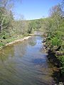
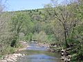
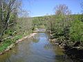
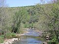
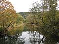
The Little Cacapon River viewed from Little Cacapon-Levels Road near Creekvale.
-
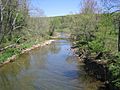
The Little Cacapon River viewed from Little Cacapon-Levels Road near Creekvale.
-
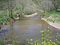
The Little Cacapon River viewed from Little Cacapon-Levels Road near Creekvale.
-
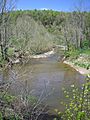
The Little Cacapon River viewed from Little Cacapon-Levels Road near Creekvale.
-
The Little Cacapon River viewed from Little Cacapon-Levels Road near Creekvale.
-
The Little Cacapon River viewed from Little Cacapon-Levels Road near Creekvale.
-
The Little Cacapon River viewed from Little Cacapon-Levels Road near Creekvale.
-
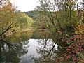
Little Cacapon River viewed from Okonoko-Little Cacapon Road near Little Cacapon.
-
Little Cacapon River viewed from Okonoko-Little Cacapon Road near Little Cacapon.
-

Little Cacapon River viewed from Okonoko-Little Cacapon Road near Little Cacapon.


