
Little Cacapon Mountain facts for kids
Quick facts for kids Little Cacapon Mountain |
|
|---|---|

Little Cacapon Mountain viewed from Ginevan Cemetery near Little Cacapon, West Virginia.
|
|
| Highest point | |
| Elevation | 1,575 ft (480 m) |
| Geography | |
| Location | Hampshire County. West Virginia, U.S. |
| Parent range | Ridge-and-Valley Appalachians |
| Topo map | USGS Hanging Rock, Levels |
| Climbing | |
| Easiest route | Hike, drive |
Little Cacapon Mountain (pronounced kə-KAY-pən or KAY-pən) is a mountain ridge in Hampshire County, West Virginia, United States. It is part of the Ridge-and-Valley Appalachians, a long chain of mountains.
This mountain gets its name from the Little Cacapon River. This river is a tributary, which means it's a smaller stream that flows into a larger one. The Little Cacapon River flows into the Potomac River and runs along the western side of the mountain.
About Little Cacapon Mountain
Little Cacapon Mountain reaches its highest point near Barnes Mill. Here, it stands about 1,575 feet (480 meters) tall.
The mountain stretches across a good distance. It starts near the Frenchburg area. Here, another ridge called Chestnut Oak Ridge joins it.
The mountain continues all the way to the Slanesville Pike. At this point, a stream called Crooked Run creates a gap. This gap separates Little Cacapon Mountain from Queens Ridge, near Higginsville.
Gallery
-
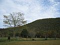
Little Cacapon Mountain viewed from Ginevan Cemetery near Little Cacapon
-
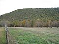
Little Cacapon Mountain viewed from Ginevan Cemetery near Little Cacapon
-
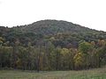
Little Cacapon Mountain viewed from Ginevan Cemetery near Little Cacapon


