
Littlestane Loch facts for kids
Quick facts for kids Littlestane Loch |
|
|---|---|

The site of Littlestane Loch
|
|
| Lua error in Module:Location_map at line 420: attempt to index field 'wikibase' (a nil value). | |
| Location | Stanecastle, North Ayrshire, Scotland |
| Type | Drained freshwater loch |
| Primary inflows | Rainfall, springs and runoff |
| Primary outflows | Red Burn |
| Basin countries | Scotland |
| Islands | None |
| Settlements | Irvine |
Littlestane Loch was once a natural lake in North Ayrshire, Scotland. It was located near Stanecastle in Irvine. Today, you can only see a small part of it. This remaining water is found within the Scottish Wildlife Trust Sourlie Nature Reserve. The loch formed naturally in a dip in the land. This dip was created by glaciers long ago. Water from the loch flowed out into the Red Burn. The Red Burn then joined the River Garnock. Much of the old loch area is now public land. Some parts have buildings on them.
Contents
The Story of Littlestane Loch

Old maps help us understand what Littlestane Loch was like. A map from 1654, based on surveys from the early 1600s, shows the loch. It looked like a large oval lake. Its water flowed out through the Red Burn. Rain and water running off the land were its main sources.
Another map from 1747-55 also clearly shows the loch. By this time, it was much smaller. A place called 'Loch Wards' was near the old loch.
Littlestane Farm was once right by the loch. This was in the 1600s. But as the loch shrank, the farm was no longer on its edge. Other old names nearby included 'Loch Mill'.
Maps from the 1800s show the loch area as marshy. It stretched into Sourlie Woods. It was also marshy near Lawthorn Wood. The old boundary of Irvine town followed the Red Burn. It then curved along the old loch shore.
In 1845, the loch was used for a curling match. Teams from Dundonald and Monkton played there. Dundonald won the game. The loch was called Sourley Loch back then.
Why the Loch Disappeared
The water from this shallow loch flowed into the Red Burn. Today, the Red Burn is mostly in pipes near the loch. Downstream, it flows in a straightened channel. It has been moved in some places. The Red Burn eventually reaches the River Garnock.
A railway line once crossed the loch's site. This was the Perceton Branch. The A736 Lochlibo Road also runs over the area. In 1910, a railway for carrying minerals was built. It went to Fergushill Collieries. This railway embankment was built right across the old loch bed.
The loch started to shrink between the 1600s and 1750s. By the 1850s, it was just marshy land. It did not even appear on maps from the early 1800s.
People likely started draining the loch in the 1700s. Alexander Montgomerie, 10th Earl of Eglinton owned much of the land. He was trying to improve farming on his estates. A lot of draining work might have happened in the 1740s. This work helped give jobs to Irish workers. They were suffering from potato famines. Many drainage projects also happened after World War I. This was when many soldiers came home.

The Drukken Steps and Robert Burns
There is a small connection to the famous poet Robert Burns. Nearby are the Drukken Steps. These steps cross the Red Burn. They are in the old Eglinton Woods. This spot was a favorite place for Robert Burns. He often visited with his friend Richard Brown. This was when Burns was in Irvine in 1781-82.
Images for kids
-
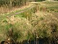
The site of the Drukken Steps over the Red Burn on the 1774 Toll road to Millburn via Higgens House.
-
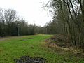
Littlestane Farmhouse, now the manse for Girdle Toll Parish Church.
-
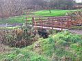
The 1960s bridge abutment at the site of the old Drukken Steps with the old Toll Road route in the background.
-
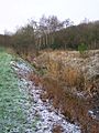
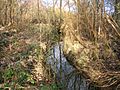
The site of the Drukken Steps and the canalised Red Burn.
-
The Red Burn near The Hill Roundabout.


