
Liverpool Weir facts for kids
Quick facts for kids Liverpool Weir |
|
|---|---|
| Lua error in Module:Location_map at line 420: attempt to index field 'wikibase' (a nil value). | |
| Location | Georges River, Heathcote Road near Newbridge Road, Liverpool, Sydney, New South Wales, Australia |
| Built | 1836 |
| Architect | David Lennox |
| Official name: Liverpool Weir Bourke's Dam | |
| Type | state heritage (complex / group) |
| Designated | 13 August 2010 |
| Reference no. | 1804 |
| Type | Weir |
| Category | Utilities – Water |
| Builders | Convict labour, directed by Captain WH Christie |
 |
|
| Country | Australia |
| Location | Liverpool |
| Coordinates | 33°55′31″S 150°55′42″E / 33.9252°S 150.9284°E |
| Purpose | water supply |
| Status | intact |
The Liverpool Weir is a special historical structure on the Georges River in Liverpool, Sydney, Australia. It was designed by David Lennox and built in 1836. The weir was constructed by people working as part of the convict system, overseen by Captain W. H. Christie. It is also known as Bourke's Dam. This important site was added to the New South Wales State Heritage Register in 2010.
Contents
History of Liverpool Weir
The Georges River and Aboriginal Peoples
For thousands of years before Europeans arrived, the land around the Georges River was home to Aboriginal peoples. These included the Darug, Tharawal, and Gandangara groups. The river was a vital pathway for travel, communication, and trade. People used light bark canoes to move up and down the river.
European settlers began arriving in the 1790s, looking for good farming land. This led to changes and challenges for the Aboriginal communities. Early interactions were sometimes difficult. In 1816, Governor Macquarie tried to make peace. He offered food, education, and land to Aboriginal people in the Liverpool area.
The construction of Liverpool Weir in 1836 changed how Aboriginal groups used the river. It made it harder for them to travel freely by canoe. The weir also slowly changed the natural environment of the river upstream.
Building the Weir for Water and Crossing
The Liverpool Weir was built in 1836 to provide water for local farms and the town of Liverpool. It also served as a crossing point over the Georges River.
The weir was designed by David Lennox, a very skilled builder. He was the Superintendent of Bridges for the colony of New South Wales. Before coming to Australia, Lennox worked on many famous bridges in Britain. He built 53 bridges in Australia and was a key figure in early Australian engineering. Liverpool Weir is the only weir he is known to have designed.
The weir was one of the last public works in Liverpool built by people working under the convict system. These workers also helped build other important structures like Lansdowne Bridge. The construction of Liverpool Weir took place between February and August 1836. Stone for the weir was brought by barges from a quarry further down the river.
Captain William Harvie Christie supervised the construction of the weir. The local community was very grateful for his work. They believed the weir helped the region become more prosperous.
How the Weir Changed the River
The Liverpool Weir was one of the first "engineered" weirs built in the colony. It separated the salty water from the fresh water of the Georges River. This allowed farmers to use the fresh water for their crops. At first, water had to be carried to the town. Liverpool didn't get a piped water supply until 1891.
The weir was the only way to cross the Georges River in Liverpool until a timber bridge was built in 1896. A wharf was also built at the weir. Boats as large as 140 tons carried timber and farm products to Sydney from here.
Early Construction Details
The weir's main wall was made of large, shaped sandstone blocks. It was built in a curved shape. Inside, there were other walls and a special clay filling called "puddle clay." This clay made the weir waterproof, creating a freshwater storage area upstream. Large sandstone slabs covered the top, allowing water to flow over and providing a wet crossing.
Repairs and Changes Over Time
The weir faced many challenges, especially from floods. As early as 1851, it needed repairs because water was leaking through the masonry. Floods in 1852 caused more damage.
In 1858, major repairs were done. Workers refilled the inside with puddle clay and added a concrete base with thick stone flagging. Parts of the front wall were rebuilt. In 1860, another big flood washed away part of the eastern bank. This meant the weir had to be extended to cross the new channel.
Over the next 100 years, the weir was mostly left alone. But decades of flooding caused a lot of damage. Major rebuilding happened in the 1970s, and more repairs in 2007–08.
In the 1970s, a concrete road was built across part of the weir, but it was later removed. In the 1980s, more repairs were done to fix erosion on the eastern bank. A special pathway for fish, called a fishway, was built in 1997. This helps native fish move past the weir.
Today, the weir no longer supplies water to the town or acts as a main crossing. Instead, it helps keep the riverbanks stable and manages the water flow in the Georges River. The fishway helps improve the river's natural environment.
What Liverpool Weir Looks Like
The Liverpool Weir is located just east of Liverpool railway station on the Georges River. It stretches across the entire width of the river and marks where the river's tidal flow stops.
You can reach the weir from Lighthorse Park on the western side or from the eastern side near Newbridge Road.
The original weir, built in 1836, raised the river's water level by about 2 meters. It had a curved downstream face made of large, cut sandstone blocks. The upstream wall was straight and also made of sandstone blocks. Inside, there were three cross walls connecting the front and back walls. These inner walls were made of stone blocks, possibly leftover from other projects.
The walls and the internal clay filling made the weir strong against water pressure. The clay filling stopped water from leaking through. The stone slabs on top acted as a spillway and a crossing.
Over the years, many repairs and additions have changed the weir. For example, in 1851, a timber wall was added to make a roadway. Later, in 1860, another timber wall was added to make the weir even taller. These changes helped increase the water storage.
By 2008, only the curved wall and some flagging on the left side were visible from the original 1836 weir. However, the internal stone cross walls and the original upstream wall were still mostly there. The clay filling has been replaced and disturbed over time due to repairs. Today, a reinforced concrete slab covers the surface, protecting the older parts of the weir.
Current Condition of the Weir
During the 2007–08 repair work, it was found that the original masonry walls and the three internal cross walls were in good shape. Many of the timber walls added during later repairs were also in good condition.
Even though many repairs and additions have changed the weir's look, much of its original shape still exists within the structure.
Key Changes Over the Years
- 1851: First extension added upstream, creating a timber roadway.
- 1855: Problems with leaks and sinking parts were noted.
- 1857: A joint report identified issues like sinking walls and a flood channel.
- 1858: Major repairs were carried out, including rebuilding parts of the front wall and refilling the interior with clay.
- Around 1860: Another extension was added upstream, making the weir taller.
- 1876: Photos show the weir's crest was much higher than its original level.
- 1890s: Many sandstone slabs on the surface were replaced with concrete.
- 1896: The weir stopped being used for water supply and as the main river crossing.
- 1970s: Part of the front wall was replaced, and a concrete road was built across the top (later removed).
- 1980s: Big repairs were done to fix erosion on the eastern bank.
- 1985: Some surface flagging was replaced with concrete units.
- 1997: A fishway was completed to help fish move past the weir.
- 2007: The weir partly collapsed after a storm.
- 2007–08: Emergency repairs were done to protect the weir from more flood damage.
Why Liverpool Weir is Important
Liverpool Weir is important because of its history, its connections to important people, and its rarity. It is the only weir known to have been designed by David Lennox, a famous builder in Australia's early history. Lennox was responsible for many bridges and other engineering projects.
The weir was one of the first "engineered" weirs built in the colony. It is also one of the oldest stone weirs still standing in Australia. It was built to supply water to a town, which was a big challenge in the early colonial era.
Liverpool Weir is also a good example of how infrastructure was built in the colony using people working under the convict system. This shows how public works were carried out during that time. Building the weir in the Georges River, which often flooded, was a major achievement. It has survived many floods and repairs over the years.
Even though repairs and additions have changed its look, Liverpool Weir is a rare 19th-century water supply structure. Its original parts and repair materials have historical value.
The weir no longer supplies water or acts as a main river crossing. However, it now offers opportunities for water-based recreation. The fishway built in 1997 helps native fish migrate upstream. The weir also helps control the riverbed and prevent erosion.
Liverpool Weir is important locally because it was the first reliable public water supply for Liverpool. It was also the main crossing point until 1894 and a hub for river transport.
Connections to Important People
Liverpool Weir has strong links to its designer, David Lennox. It also connects to the people who built it under the convict system and to Captain William Christie, who supervised the work.
David Lennox was a master builder who designed many bridges in New South Wales and Victoria. Several of his bridges, like Lansdowne Bridge and Lapstone Bridge, are still standing and are listed as heritage sites.
Captain William Harvie Christie was praised by the local community for his work in completing the Liverpool Weir. The people who built the weir were likely the same groups who worked on Lennox's other big projects.
Images for kids
-
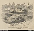
An old woodcut image of Liverpool Weir.
