Llanos de Moxos (archaeology) facts for kids
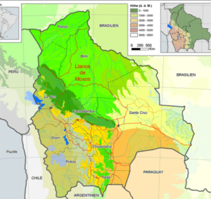
The Llanos de Moxos (pronounced "YAH-nos day MO-hos"), also called the Moxos Plains or the Beni Savanna, is a huge area in Beni Department, Bolivia. It's famous for amazing discoveries of ancient societies that lived there long before Christopher Columbus arrived. These discoveries show that many well-organized indigenous people lived here. This idea was different from what many archaeologists, like Betty Meggers, used to think. They believed the Amazon River Basin couldn't support large populations. They thought the people there were mostly hunter-gatherers or simple farmers.
But in the 1960s, geologists and a geographer named William Denevan started showing that there were huge, ancient earthworks built in the Amazon, especially in the Llanos de Moxos. Many types of these earthworks have been found. They include big mounds, raised fields for farming, natural and human-made forest islands, canals, raised pathways (causeways), ring ditches, and even fish weirs.
Archaeologists are still learning a lot about these ancient cultures. We don't know if these groups were united under one ruler. It seems they were many small, independent groups speaking different languages. New technology called Lidar (which uses lasers to map the ground) is helping scientists find even more hidden sites. This will help us understand these ancient people much better.
Contents
Environment of the Llanos
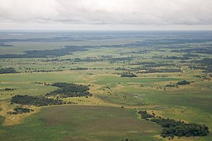
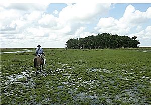
The Llanos de Moxos is a vast area in northern Bolivia. Its size is estimated to be between 110,000 square kilometres (42,000 sq mi) and 200,000 square kilometres (77,000 sq mi). This region is very flat with many rivers and shallow lakes. It has a tropical climate with clear wet and dry seasons. A big part of the land, about 50 to 60 percent, is flooded for four to ten months each year. Most of the Llanos is in the area drained by the Mamoré River.
Today, the main city in the Llanos is Trinidad. East of Trinidad is a place called Casarabe. Recent lidar data and older archaeological surveys show that the ancient Casarabe culture had a very connected and dense system of settlements. This system covered more than 4,000 km2 (1,500 sq mi) with many sites linked together. The Casarabe culture is known for its "low-density urbanism," which means they had towns spread out, not tightly packed cities. This culture thrived between AD 500 and 1400.
For a long time, experts thought that large, complex societies couldn't grow in the Amazon's lowland forests. They believed this was because of poor soil, lack of protein, no domesticated animals, and simple tools. But in 2008, discoveries in the Llanos de Moxos challenged this idea. Newer lidar data has quickly shown how wrong that old idea was. The lidar data reveals that the ancient people built amazing structures to overcome the natural challenges of the land.
Generally, the soil in the Llanos gets less fertile from south to north. The southern parts benefit from rich sediments brought by rivers flowing from the nearby Andes mountains. Further north, the soil becomes less fertile, like the typical lateritic soils found in the Amazon. However, around ancient settlements, a special dark earth called "terra mulata" or terra preta is found. This soil is very fertile because ancient people improved it by adding organic materials. The people of Moxos changed their landscape by building raised garden beds and making the soil better.
Amazing Earthworks
Scientists still discuss whether many of the earthworks in the Llanos de Moxos were made by humans or are natural. They also disagree on how many people built them and how complex their societies were. Some think there were many people, while others believe a smaller population built them over a long time. There are no stone structures here, unlike the mountain civilizations to the west, because there's no surface stone in the area.
Mounds (called lomas in Spanish) are found all over the Llanos de Moxos. There are an estimated 20,000 mounds in total! About 200 to 300 of these are very large, rising from 3 metres (9.8 ft) to 5.5 metres (18 ft) high. They cover an area of 2 hectares (4.9 acres) to 11 hectares (27 acres). These large mounds are grouped in certain areas, suggesting that different regional groups existed, each with its own living and ceremonial centers. Smaller mounds, less than 3 metres (9.8 ft) high, were used for homes and farming.
Agricultural fields show that farming in the Llanos de Moxos was done on long, narrow strips of land. These strips were raised by humans up to 1 metre (3.3 ft) above the floodwaters. The remains of these strips, called "camellónes" in Spanish, can be as long as 600 metres (2,000 ft) and 20 metres (66 ft) wide. These raised fields helped drain water during the rainy season. It's thought that raised fields might have covered as much as 1,000,000 hectares (2,500,000 acres) of land in the Moxos Plains. Maize (corn) and cassava (yuca) were likely the main crops.
Forest islands are areas of trees that rise above the surrounding flooded plains. Many of these islands were built by humans. They are often the remains of old mounds and settlements. Forest islands were used for homes, farming, hunting, and gathering wild plants.
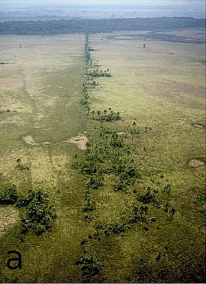
Canals and causeways (raised paths) often connected different human settlements. They spread out from the large mounds. These structures had many uses: for travel, for draining water, as boundary markers, and for improving fishing. Some zigzag causeways are believed to have been fish weirs, which are traps to catch fish. Fish were probably a very important source of food for the ancient people.
Ring ditches are found in many areas. These ditches were built to surround settlements. They helped drain water during the rainy season and store water during the dry season. They were usually less than 1 metre (3.3 ft) deep and 3 metres (9.8 ft) to 5 metres (16 ft) wide.
Different Regions
Scientists have found four main eco-archaeological regions in the Llanos de Moxos, each with its own unique features.
Region One - This area is north of the city of Santa Ana del Yacuma and west of the Mamoré River. It has very wet and poor soils. The main signs of ancient people here are many large raised agricultural fields. These fields were essential for drainage and improving the soil. Even though many people likely lived here long ago, there isn't much evidence of a very complex society.
Region Two - This region is east of the Mamoré River, around the town of Baures and the Baures River. It has many forest islands, mostly natural. These islands were inhabited and surrounded by ditched fields, ring ditches, fish weirs, and many canals and zigzag causeways. It seems the earthworks in this area were built not long before the Spanish arrived.
Region Three - West of the city of Trinidad, near the town of San Ignacio de Moxos, this area has quite fertile soils. It has many earthworks, including mounds, human-made forest islands, raised fields, and causeways. The large number and variety of earthworks here suggest a more complex ancient society than in regions one and two.
Region Four - East of the city of Trinidad, around the town of Casarabe, this is the most fertile and least flooded part of the Llanos. It has many large mounds and connected agricultural fields and earthworks. This region likely had the most complex societies in the ancient Llanos de Moxos.
The People of Moxos
Archaeologists have found signs of humans in the Llanos de Moxos dating back to 8000 BC. These signs are in shell middens (ancient trash heaps) on several forest islands.
Some artifacts found in the large mounds have been dated using radiocarbon dating to as far back as 800 BC. When the first Spaniards arrived, they found six main groups of people in the Llanos: the Moxo (or Mojo), Movima, Canichana, Cayuvava, Itonama, and Bauré. We know the names of 26 other groups as well. The Spanish thought the Baure were the most "civilized," followed by the Moxo. The other groups lived in smaller communities on less favorable lands. The Canichana were fierce hunters who lived along the Mamoré River.
The Llanos was a mix of many different languages. The Baure and Moxo spoke Arawak languages. Experts believe that Arawakan people originally came from further north in the central Amazon basin. They moved to the Llanos, bringing their cassava-based farming with them. Most of the other groups were probably living in the Llanos before the Arawak-speakers. However, the Canichana's unique hunting and warrior culture suggests they might have moved into the Llanos more recently when the Spanish first arrived.
Archaeologist Clark Erickson summarized what early Spanish explorers said about Baure villages:
the villages were large by Amazonian standards and were laid out in formal plans which included streets, spacious public plazas, rings of houses, and large central bebederos (communal men's houses). According to the Jesuits, many of these villages were defended through the construction of deep circular moats and wooden palisades enclosing the settlements. Settlements were connected by causeways and canals that enabled year round travel.
Early Spanish explorers in 1617 reported seeing Llanos villages with up to 400 houses. Modern experts calculate that such a village would have had about 2000 people.
William Denevan estimated that the population of the Llanos de Moxos before Columbus was about 350,000. He thought the population was around 100,000 in 1690, when Jesuit Catholic priests first set up missions there. David Block, on the other hand, estimated only about 30,000 people in the Llanos in 1679. Either way, the population had dropped a lot. This was due to European diseases, the impact of the Spanish conquest, and slave raids by the Spanish and Portuguese. In 1720, the Jesuits in the Llanos counted about 30,000 people living in their missions. The population of the Llanos stayed fairly steady after that until the 1800s.
See also
 In Spanish: Cultura hidráulica de las Lomas para niños
 | William M. Jackson |
 | Juan E. Gilbert |
 | Neil deGrasse Tyson |


