
Loachapoka, Alabama facts for kids
Quick facts for kids
Loachapoka, Alabama
|
|
|---|---|

Loachapoka Town Hall (left) and Fred's Feed & Seed and Pickin’ Parlor (right)
|
|

Location of Loachapoka in Lee County, Alabama
|
|
| Country | United States |
| State | Alabama |
| County | Lee |
| Area | |
| • Total | 1.15 sq mi (2.97 km2) |
| • Land | 1.14 sq mi (2.95 km2) |
| • Water | 0.01 sq mi (0.02 km2) |
| Elevation | 679 ft (207 m) |
| Population
(2020)
|
|
| • Total | 160 |
| • Density | 140.60/sq mi (54.27/km2) |
| Time zone | UTC-6 (CST) |
| • Summer (DST) | UTC-5 (CDT) |
| ZIP code |
36865
|
| Area code(s) | 334 |
| FIPS code | 01-43744 |
| GNIS feature ID | 0121934 |
Loachapoka is a small town in Lee County, Alabama, United States. It is located very close to Auburn and about 5 miles west of Auburn University. In 2020, about 160 people lived there.
The name "Loachapoka" comes from the Muskogee people. It means "turtle killing place." The word locha means "turtle," and poga means "killing place." Loachapoka was also the first place to have a Rosenwald School, which were schools built for African American children in the early 1900s.
Contents
History of Loachapoka
Loachapoka was a town for the Creek Indian people for many years before white settlers arrived. Before the Native Americans were moved to Oklahoma, Loachapoka had a population of 564 people.
When European-Americans settled there, Loachapoka became an important trading center. It was even called Ball's Fork for a short time. In 1845, it became the end point of the railroad coming from Montgomery. This made it even more important for trade.
Loachapoka was at its busiest in the early 1870s, with almost 1,300 people living there. However, things changed quickly. A big economic problem called the Panic of 1873 caused trade to slow down. Also, new rail lines were built in other areas. This led to Loachapoka's economy getting smaller.
By the mid-1900s, Loachapoka became a quiet farming community. In the early 2000s, it started to grow again as a small town near Auburn. Today, the mayor of Loachapoka is Zach Holmes.
Culture and Fun Events
Loachapoka is known for its fun community events. It used to have two fall festivals on the same day: the Syrup Sopping Day and the Lee County Historical Fair.
- The Syrup Sopping Day showed how syrup was made in the old ways. They used plants like sorghum and ribbon cane.
- The Lee County Historical Fair showed what life was like in the 1850s in this part of Alabama.
Now, these two festivals have joined together into one big event called Pioneer Day. This combined festival brings more than 20,000 people to Loachapoka every year!
The Lee County Historical Society Museum is also in Loachapoka. It is located in an old general store that was built in 1845. This museum is part of "Pioneer Park," which is a large park with nine historic buildings and five gardens. It helps visitors imagine what life was like in the 1850s.
Loachapoka is also the hometown of Freddie Hart, a famous country music singer.
Geography of Loachapoka
Loachapoka is located at 32°36′17″N 85°35′49″W / 32.60472°N 85.59694°W. The town covers an area of about 1.2 square miles (2.97 square kilometers). Almost all of this area is land.
Population Changes
Loachapoka's population has changed a lot over the years.
- In 1880, 408 people lived there.
- In 1890, the population was 357.
- The town did not appear on census records for a while.
- In 1930, it appeared again with 360 residents.
- It was not listed again in 1940.
- Loachapoka officially became a town again in 1974.
- In 2010, 180 people lived in Loachapoka.
- By 2020, the population was 160.
Notable Person
- Freddie Hart, a country music singer and songwriter.
Images for kids
-
Loachapoka Town Hall
-
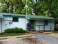
The post office in Loachapoka (ZIP code: 36865)
-

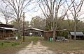
Loachapoka High School
-
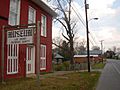
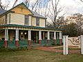
A general store built in 1845 now serves as The Lee County Historical Society Museum
-
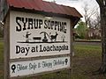
The famous Syrup Sopping sign as seen from Alabama State Route 14
-
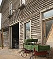
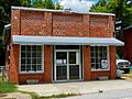
Fred's Feed & Seed, located in downtown Loachapoka, also serves as a music venue and "pickin' parlor." Fred's regularly features traditional barn dances on the first and third Thursdays of every month.
-
The Loachapoka Historic District was added to the National Register of Historic Places on May 11, 1973.
-
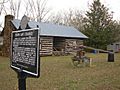
The Ruth Purdy Speake House and Historic Marker
-
The now-defunct Rattling Gourd Gallery, Downtown Loachapoka
-
The Saugahatchee Creek, which runs through the area, serves as a popular swimming hole for locals during spring and summer months.
-

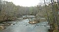
A span across The Saugahatchee Creek

.JPG)


See also
 In Spanish: Loachapoka para niños
