Loch Dochart facts for kids
Quick facts for kids Loch Dochart |
|
|---|---|
 |
|
| Location | Perthshire, Scotland |
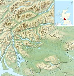
| Coordinates | 56°23′47″N 4°35′3″W / 56.39639°N 4.58417°W |
| Type | freshwater loch |
| Primary inflows | River Fillan |
| Primary outflows | River Dochart |
| Basin countries | Scotland |
| Max. length | 1.06 km (0.66 mi) |
| Max. width | 0.26 km (0.16 mi) |
| Surface area | 19 ha (46 acres) |
| Average depth | 1.5 m (5 ft) |
| Max. depth | 3.4 m (11 ft) |
| Water volume | 284,100 m3 (10,032,000 cu ft) |
| Surface elevation | 156 m (513 ft) |
| Islands | 1 islet |
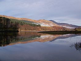
Loch Dochart is a beautiful, small freshwater loch (which is the Scottish word for a lake). You can find it on the Lochdochart Estate in Stirling, part of the amazing Scottish Highlands. It's located about 1.7 km (1.1 mi) east of the town of Crianlarich. The loch sits right at the foot of a large mountain called Ben More.
The Island and Its Castle
In the middle of Loch Dochart, there's a small island covered with trees. On this island, you can see the old ruins of a castle. This castle was built a long time ago, between 1583 and 1631, by a person named Sir Duncan Campbell. Imagine a castle on an island!
Exploring the Loch's Depths
Scientists have studied Loch Dochart to learn more about it. On May 11, 1902, two people named T.N. Johnston and James Parsons carefully measured the loch. They charted its depths as part of a big project. This project was called The Bathymetrical Survey of Fresh-Water Lochs of Scotland 1897-1909, led by Sir John Murray. This survey helped create detailed maps of many Scottish lochs.
 | James B. Knighten |
 | Azellia White |
 | Willa Brown |


