Loch na Creige Duibhe (Lochaber) facts for kids
Quick facts for kids Loch na Creige Duibhe |
|
|---|---|

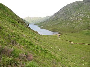
Head of Loch na Creige Duibhe
|
|
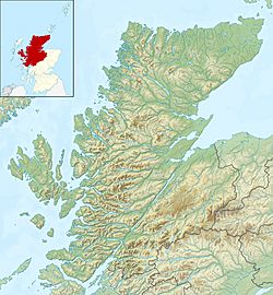
| Location | Morar, Lochaber, Scotland |
| Coordinates | 56°54′10″N 5°40′28″W / 56.90283°N 5.67452°W |
| Type | freshwater loch |
| Primary inflows | Loch na Creige Duibhe |
| Primary outflows | Loch Màma |
| Basin countries | Scotland |
| Max. length | 0.8 mi (1.3 km) |
| Max. width | 0.12 mi (0.19 km) |
| Surface area | 36.25 acres (0.1467 km2) |
| Average depth | 42.5 ft (13.0 m) |
| Max. depth | 93 ft (28 m) |
| Water volume | 52,000,000 cu ft (1,500,000 m3) |
| Surface elevation | 359.7 ft (109.6 m) |
Loch na Creige Duibhe is a small, clear freshwater lake, also known as a loch in Scotland. You can find it in a beautiful area called Morar in the Scottish Highlands. This loch stretches from east to west. Its water flows into another loch called Loch Màma, which is to its west.
Scientists believe that Loch na Creige Duibhe and Loch Màma were once connected. They might have formed one big loch! Over time, a stream named Allt Dearg brought down lots of rocks and dirt. This material probably split the big loch into the two separate ones we see today.
Exploring Loch na Creige Duibhe
Did you know that people have been studying Loch na Creige Duibhe for a long time? Back on July 11, 1902, two explorers named James Parsons and T.R.H. Garrett carefully measured the loch. They were part of a big project led by Sir John Murray and Laurence Pullar. This project was called the Bathymetrical Survey of Fresh-Water Lochs of Scotland 1897-1909.
What is a Bathymetrical Survey?
A bathymetrical survey is like creating a detailed map of the bottom of a lake or ocean. Scientists use special tools to measure how deep the water is in different places. They also look at the shape of the lakebed. This helps them understand how the loch was formed and how its water moves. It's a bit like taking an X-ray of the loch!


