
Loei province facts for kids
Quick facts for kids
Loei
เลย
|
|||
|---|---|---|---|
 |
|||
|
|||
| Motto(s):
City of the sea of mountains, coldest place in Siam, with beautiful flowers of three seasons
|
|||

Map of Thailand highlighting Loei province
|
|||
| Country | Thailand | ||
| Capital | Loei | ||
| Area | |||
| • Total | 10,500 km2 (4,100 sq mi) | ||
| Area rank | Ranked 16th | ||
| Population
(2019)
|
|||
| • Total | 642,950 | ||
| • Rank | Ranked 42nd | ||
| • Density | 61/km2 (160/sq mi) | ||
| • Density rank | Ranked 68th | ||
| Human Achievement Index | |||
| • HAI (2017) | 0.5819 "average" Ranked 42nd |
||
| Time zone | UTC+7 (ICT) | ||
| Postal code |
42xxx
|
||
| Calling code | 042 | ||
| ISO 3166 code | TH-42 | ||
| Vehicle registration | เลย | ||


Loei (Thai: เลย) is a beautiful province in Thailand. It is located in the Isan region, which is in the upper northeastern part of the country. Loei is known for its mountains and cooler weather.
It shares borders with several other Thai provinces: Nong Khai, Udon Thani, Nong Bua Lamphu, Khon Kaen, Phetchabun, and Phitsanulok. To the north, Loei borders Laos, a neighboring country.
Contents
History of Loei Province
Loei province was first settled by a Thai group from the ancient Kingdom of Yonok Chiang Saen. Two leaders, Khun Pha Muang and Bang Klang Hao, founded early villages here.
Later, due to dry weather and sickness, the villagers moved to the area where Loei city is today. In 1907, King Chulalongkorn (also known as Rama V) officially made Loei a province. You can learn more about Loei's past, its religions, and traditions at the Loei Cultural Centre.
Exploring Loei's Geography

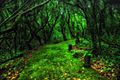
Loei is a very mountainous province. The main city of Loei sits in a fertile valley surrounded by tall mountains. These mountain tops are often covered in fog and have many different kinds of plants.
Some of the most famous mountains in Loei are Phu Kradueng, Phu Luang, and Phu Ruea. The Loei River flows through the province and eventually joins the Mekong River. The Mekong River forms part of Loei's northern border with Laos.
National Parks in Loei
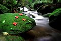
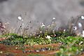
Loei province is home to several amazing national parks, which are special protected areas for nature. These parks help protect the forests, wildlife, and beautiful landscapes.
- Phu Kradueng National Park: This park is famous for its bell-shaped mountain, Phu Kradueng. It's a popular spot for hiking and enjoying nature.
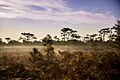
- Phu Ruea National Park: Known for its cool climate and beautiful flowers, especially during the winter.
- Phu Suan Sai National Park: This park offers stunning views and diverse plant life.
- Phu Pha Man National Park: Features limestone mountains and caves.
- Phu Hin Rong Kla National Park: While mostly in Phitsanulok, a part of this park extends into Loei. It has unique rock formations and historical significance.
- Na Yung–Nam Som National Park: Another beautiful park that helps protect the region's natural environment.
Wildlife Sanctuaries in Loei
Besides national parks, Loei also has wildlife sanctuaries. These areas are even more focused on protecting animals and their habitats.
- Phu Luang Wildlife Sanctuary: A large sanctuary known for its diverse wildlife, including elephants and various bird species.
- Phu Khat Wildlife Sanctuary: This sanctuary provides a safe home for many animals.
- Phu Kho–Phu Kratae Wildlife Sanctuary: Another important area for protecting local wildlife.
People of Loei
Loei province is home to several groups of Tai people. The original people of the area are called the Tai Lue. Other groups living here include the Phuan, Tai Dam, Thai, and Chinese people. The Tai Phuan people moved to Loei from Luang Prabang in Laos a long time ago.
Symbols of Loei
The official seal of Loei province shows the stupa at Phra That Si Song Rak. This important monument was built in 1560 by two kings: King Maha Chakrapat of the Ayutthaya Kingdom (from Thailand) and King Saysettha of Lan Xang (from Laos). It was built to show the friendship between their two kingdoms.
The official provincial tree of Loei is the Khasi pine (Pinus kesiya).
Loei's provincial slogan describes it well: "city of the sea of mountains, coldest place in Siam, with beautiful flowers of three seasons." This highlights its many mountains, cool weather, and colorful plant life.
Loei's Economy and What They Produce
Agriculture is a very important part of Loei's economy. Farmers grow special crops like macadamia nuts, passion fruit, and Arabica coffee in the cooler highlands. On the flatter lands, they grow bananas, sesame, and rubber.
Loei is also a popular place for ecotourism. This means people visit to enjoy its natural beauty and learn about its unique mix of northern and northeastern Thai cultures.
In Wang Saphung District, there is a large gold mine. This mine provides jobs for many local people.
How Loei is Governed
Loei province is divided into 14 main areas called districts (amphoe). These districts are then split into smaller parts called subdistricts (tambons), and even smaller units called villages (mubans).
Here are the 14 districts:
- Mueang Loei
- Na Duang
- Chiang Khan
- Pak Chom
- Dan Sai
- Na Haeo
- Phu Ruea
- Tha Li
- Wang Saphung
- Phu Kradueng
- Phu Luang
- Pha Khao
- Erawan
- Nong Hin
Getting Around Loei
You can travel to and within Loei using different routes. Route 201 goes from Chiang Khan in the north, through Loei city, and down to Non Sa-at. Route 203 heads west towards Phu Ruea and then turns south.
Loei also has its own airport, Loei Airport, which makes it easier for people to visit.
Human Achievement Index
The Human Achievement Index (HAI) is a way to measure how well people are doing in different areas of life, like health, education, and income. In 2017, Loei province had an HAI value that was considered "average," ranking 42nd among Thailand's 76 provinces. This index helps show areas where a province is doing well and where it might need to improve.
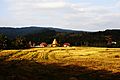
Gallery
-
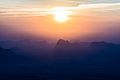
Sunrise, Pha Nok Aen
-
Phu Kradueng National Park
-
Phu Kradueng National Park
-
Phu Kradueng
-
Phu Kradueng
-
Phu Kradueng
-
Phu Ruea National Park
-
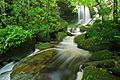
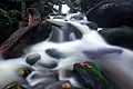
Man Daeng Waterfall, Phu Hin Rong Kla National Park
-
Na Haeo District
-
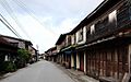
Chiang Khan


See also
 In Spanish: Provincia de Loei para niños
