Lone Cone facts for kids
Quick facts for kids Lone Cone |
|
|---|---|

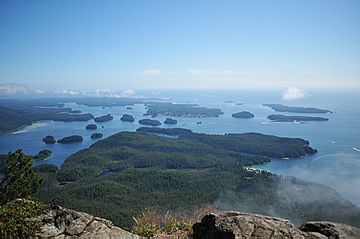
View looking west from the summit of Lone Cone
|
|
| Highest point | |
| Elevation | 742 m (2,434 ft) |
| Prominence | 697 m (2,287 ft) |
| Geography | |
| Location | Meares Island, British Columbia, Canada |
| Topo map | NTS 92F/04 |
Lone Cone is a mountain that stands about 6 kilometers (4 miles) north of Tofino in British Columbia, Canada. It is also about 7 kilometers (4.3 miles) northwest of Mount Colnett. Lone Cone is located on the western part of Meares Island.
This mountain has always been an important landmark for everyone living nearby. It stands tall and can be seen from far away. Early settlers in the area had a special belief about Lone Cone. They thought that if clouds covered the top of the mountain, it meant good weather was coming soon.
How Lone Cone Was Formed
Lone Cone is made of a type of rock called igneous rock. This kind of rock forms when hot, melted rock (magma or lava) cools down and hardens.
The rocks of Lone Cone are part of something called the Catface Intrusions. These are large bodies of rock, specifically quartz diorite, that pushed their way into older rocks. Scientists have studied these rocks and found that they are very old. At least one part of these formations is about 41 million years old!

