Long Island, County Cork facts for kids
|
Native name:
Inis Fada
|
|
|---|---|
| Geography | |
| Location | Long Island Bay |
| Coordinates | 51°30′N 9°33′W / 51.500°N 9.550°W |
| Area | 1.8 km2 (0.69 sq mi) |
| Administration | |
|
Ireland
|
|
| Province | Munster |
| County | Cork |
| Barony | Carbery West |
| Demographics | |
| Population | 20 (2016) |
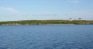
Long Island, also known by its old Irish name Inishfada (meaning "long island"), is a cool island located off the coast of Schull in County Cork, Ireland. It's called Long Island because it's about 4.8 kilometers (3 miles) long but only 0.8 kilometers (half a mile) wide!
Even though it's long, it's quite small. It's the third biggest island in a group called Carbery's Hundred Isles. The island covers about 1.8 square kilometers (0.7 square miles). You can spot its most famous landmark, the Copper Point lighthouse, at its eastern end. This lighthouse helps guide boats into Schull Harbour.
Long Island's Past
Long Island used to be a much busier place. In the 1840s, over 300 people lived there! Today, you can still see the remains of old homes and buildings that were left behind. These ruins show how many more people once called the island home.
The population has changed a lot over the years. Here's how many people lived on the island at different times:
| Historical population | |||||||||||||||||||||||||||||||||||||||||||||||||||||||||||||||||||
|---|---|---|---|---|---|---|---|---|---|---|---|---|---|---|---|---|---|---|---|---|---|---|---|---|---|---|---|---|---|---|---|---|---|---|---|---|---|---|---|---|---|---|---|---|---|---|---|---|---|---|---|---|---|---|---|---|---|---|---|---|---|---|---|---|---|---|---|
|
|
||||||||||||||||||||||||||||||||||||||||||||||||||||||||||||||||||
| Source: | |||||||||||||||||||||||||||||||||||||||||||||||||||||||||||||||||||
Life on Long Island
Long Island has some modern conveniences. Part of the island has a paved road, which makes getting around easier. There's also an old, overgrown road that leads to a former copper mine.
The main way people make a living on the island is through farming. It's a quiet place where people work with the land.
Getting to the Island
A ferry service connects Long Island to the mainland. The ferry leaves from Colla Pier. During the summer, it runs five days a week. In the winter, it runs three days a week. This ferry is the main way for people and supplies to reach the island.
Island Power
Long Island gets its electricity from the mainland. A special cable, called a submarine power cable, runs underwater to bring power to the island. This means residents have reliable electricity, just like people on the mainland.
Island Geography
Long Island is located in Long Island Bay. As we mentioned, it's about 4.8 kilometers (3 miles) long and 0.8 kilometers (half a mile) wide. It sits about 600 meters (0.4 miles) away from Colla Pier. Colla Pier is about 3 kilometers (1.9 miles) west of Schull.
The water between Long Island and the mainland is called Long Island Channel. The only way to reach the island is by boat, making it a truly unique and somewhat isolated spot.
 | Isaac Myers |
 | D. Hamilton Jackson |
 | A. Philip Randolph |


