Long Spur (conservation area) facts for kids
Quick facts for kids Long Spur |
|
|---|---|
| Location | Bland County Virginia, United States |
| Nearest town | Bland, Virginia |
| Area | 6,413 acres (25.95 km2) |
| Administrator | U.S. Forest Service |
Long Spur is a special wild area located in the George Washington and Jefferson National Forests in western Virginia. It's considered a "Mountain Treasure" by The Wilderness Society. This means it's a very important place that should be protected. They want to keep it safe from things like logging and building new roads.
You can explore Long Spur on trails, including an old part of the famous Appalachian Trail. There's also a trail that follows Spur Branch, a stream where native trout live. For amazing views, you can visit High Rock. It's just outside the area on the northeast side. Long Spur is part of a larger group of wild areas called the Walker Mountain Cluster.
Contents
Exploring Long Spur: Location and Trails
Long Spur is nestled in the Appalachian Mountains of Southwestern Virginia. It's located east of Interstate 77 and about 3 miles southeast of the town of Bland, Virginia.
Getting Around: Paths and Roads
The main paths inside Long Spur are an old section of the Appalachian Trail and a foot trail along Spur Branch. This trail goes from Virginia State Route 602 to the old Appalachian Trail. Even though these aren't official trails, hikers and hunters keep them clear for use.
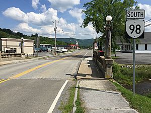
You can reach the area by car using Virginia State Route 602 (Spur Branch Road) on the north side. Virginia State Route 601 (Little Creek Road) provides access from the south. Route 602 also continues past Spur Branch to the High Rock viewpoint.
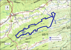
The map next to this text shows the boundary of the Long Spur wild area. This boundary was decided by The Wilderness Society. You can find more roads and trails on National Geographic Maps, specifically map 787. For even more details, like topographic maps and aerial views, you can click on the coordinates link at the top right of this page.
You can also find old logging roads that lead into the area. In the early 1900s, a lot of trees were cut down in the Appalachian Mountains. This left behind many logging roads. Some of these are now overgrown but can still be used. You can find these old roads and even old railroad paths by looking at historical topographic maps from the United States Geological Survey (USGS). The Long Spur wild area is shown on the USGS maps called Bland and Long Spur.
Nature and Wildlife in Long Spur
Long Spur is part of a large forest area known as the Central Appalachian Broadleaf Coniferous Forest-Meadow Province. This means you'll find many different types of trees here.
Trees and Plants
In the valleys and along stream banks, you might see trees like yellow poplar, northern red oak, white oak, basswood, and eastern hemlock. On the north and west sides of the mountains, white oak, northern red oak, and hickory trees are common. On the tops of ridges and in more open spots, you'll find chestnut oak, scarlet oak, and yellow pine.
Animals and Special Habitats
To help animals, five artificial waterholes have been created by blasting into rocks. These provide important water sources for wildlife. You can also find unique areas called glades with box huckleberry plants. These are special plant communities. Spur Branch, a stream in the area, is home to a population of wild trout.
The varied landscape of Long Spur creates many different environments. You'll find hot, dry, windy ridges and cool, moist, protected coves. There are also rich bottomlands near streams. Some parts of the forest have very old trees, with some stands on the western side being at least 140 years old.
Mountains and Waterways
Long Spur is part of the Ridge-and-Valley Appalachians. This area is known for its long, parallel ridges and valleys. The ridges are made of sandstone and shale, while the valleys are formed from limestone or shale.
Key Mountains and Streams
Big Walker Mountain and Long Spur are the main mountains here. They have both steep and gentle slopes. You'll find gentle slopes along Little Walker Creek, a stream that runs parallel to Virginia State Route 601 on the southern border. Many smaller streams flow into Little Walker Creek. Spur Branch is an important stream in the northeast that also flows into Little Walker Creek.
Canoeing on Little Walker Creek
In winter and early spring, the water levels in Little Walker Creek are often high enough for canoeing. The creek is about 30 feet wide and flows through a peaceful valley with farmland. Sometimes, ridges rise steeply from the creek, making you feel far away from towns and cities. However, be careful after the creek passes under the Route 100 bridge. Here, it starts to flow through a rocky gorge filled with large boulders.
The lowest point in Long Spur is 2080 feet, found near Little Walker Creek. The highest point is 3120 feet, located on the top of Long Spur mountain.
How the Forest Service Manages Long Spur
The U.S. Forest Service looks at its lands to decide which areas might be good for "wilderness designation." If an area gets this special designation, it means it will be highly protected from development. Areas that are suitable for this are called inventoried roadless areas.
Protecting Roadless Areas
Later, a "Roadless Rule" was put in place. This rule limits building new roads in these special areas. It helps protect the environment by reducing the negative effects of road construction. This rule helps with the conservation of roadless areas. Long Spur was included in this review, so it is protected from new road building and timber sales.
Power Lines and Habitats
A 765 kilovolt power line, built in 2003, runs through the area. A smaller section of Long Spur, near High Rock, has old-growth forest. This part is also important habitat for the "Indiana Bat," a type of bat that needs special protection.
The Forest Service also categorizes its lands by "recreational opportunity setting." This helps visitors understand what kind of activities they can do. A large part of Long Spur is called "Remote Backcountry-Non-motorized." This means it's a quiet area where you can't use motorized vehicles. A section on the south side, near Little Walker Creek, is labeled "Mix of Successional Habitats" and "Old Growth with Disturbance."
History of Long Spur
While no very old historical sites were found in a survey of 247 acres, experts believe the area might still hold important historical clues. This means there's a good chance that prehistoric or historic sites could be discovered here in the future.


