Los Monjes Archipelago facts for kids

Los Monjes
|
|
| Geography | |
|---|---|
| Location | Caribbean Sea |
| Coordinates | 12°22′N 70°54′W / 12.367°N 70.900°W |
| Area | 0.24 km2 (0.093 sq mi) |
| Highest elevation | 72 m (236 ft) |
| Administration | |
| Status | Federal Dependency |
The Los Monjes islands (in Spanish: Archipiélago Los Monjes) are a group of small islands. They are a federal dependency of Venezuela. These islands are found in the Caribbean Sea, about 80 kilometers (50 miles) northwest of the Gulf of Venezuela. They are also about 35 kilometers (22 miles) off the coast of the Guajira Peninsula. This area is near the border between Colombia and the Venezuelan state of Zulia.
Contents
History of Los Monjes Islands
It is thought that the Spanish explorer Alonso de Ojeda discovered the Los Monjes islands in 1499. He named them "Los Monjes" because their rock shapes looked like the hoods worn by monks. These islands have caused some disagreements between the governments of Colombia and Venezuela. This is because they have not fully agreed on where their sea borders should be.
Early Border Discussions
In 1833, a treaty called the Michelena-Pombo Treaty tried to divide the Guajira Peninsula between Venezuela and Colombia. However, Venezuela's government did not approve this treaty. They felt it was not fair to their country in several ways.
In 1856, Venezuela complained when Colombia tried to give away rights to collect guano (bird droppings used as fertilizer) from the islands. This plan did not happen in the end.
On August 22, 1871, the Venezuelan government included the Los Monjes islands as part of "Territorio Colón." This was a special area for islands that were part of Venezuela but not yet states.
Later Agreements and Decisions
In 1891, Queen María Cristina of Spain made a decision about the border. She said that Colombia owned most of the Guajira Peninsula. This decision was based on older rules from 1777 and 1790.
In 1922, a Swiss decision also agreed with the earlier border terms.
In July 1938, a new law in Venezuela officially made the Los Monjes islands part of the Federal Dependencies.
Venezuela's Sovereignty Recognized
In 1952, something important happened. The acting president of Colombia, Roberto Urdaneta Arbeláez, sent a message to Venezuela. Through his foreign minister, he stated that Colombia did not object to Venezuela owning the Los Monjes Archipelago. This meant Colombia recognized Venezuela's control over the islands.
Venezuela thanked Colombia for this recognition. On November 29, 1952, the Venezuelan flag was raised on the islands. This event, led by Venezuelan general Marcos Pérez Jiménez, marked the start of Venezuela's active presence on the islands. They even set up a scientific and military base there.
Modern Border Events
On March 31, 1978, Venezuela signed a treaty with the Netherlands. This treaty set the sea border between Venezuela and the island of Aruba. Aruba was part of the Netherlands Antilles at that time. The Los Monjes islands were used as a key point for drawing this border.
On August 9, 1987, a Colombian Navy ship, the ARC Caldas, sailed into waters near the islands. Venezuela considered these waters its own. This caused a lot of tension between the two countries. Both governments prepared their military forces, including Venezuelan F-16 fighter jets. The Colombian ship later left the area without any fighting.
On January 22, 1999, Rafael Caldera, who was then the President of Venezuela, made a big change. He started a project to connect the two main southern islands of Los Monjes. Workers used rocks from the islands to build an artificial bridge. They also built a secure port.
Geography of Los Monjes Islands
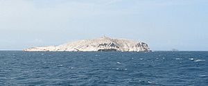
The Los Monjes islands are mostly steep rocks that rise straight out of the sea. They do not have any sandy beaches or easy places to land. The Venezuelan Navy has a base on the largest southern island, where they built a pier.
The islands do not have natural resources like fresh water or plants. Everything they need must be brought from the mainland. Fishing is the main activity around the islands. Fishing boats often come from the nearby Guajira and Paraguaná Peninsulas.
There are three main island groups, covering a total area of about 0.2 square kilometers (0.08 square miles):
- Monjes del Sur (12°22′N 70°54′W / 12.367°N 70.900°W): These are the two largest islands. They are connected by an artificial dam. The southern island is the tallest, reaching about 70 meters (230 feet) high. It also has a lighthouse.
- Monjes del Este (12°24′N 70°51′W / 12.400°N 70.850°W): This is a small rock located about 5.3 kilometers (3.3 miles) northeast of Monjes del Sur. It reaches a height of about 43 meters (141 feet).
- Monjes del Norte (12°30′N 70°55′W / 12.500°N 70.917°W): This group is about 12.3 kilometers (7.6 miles) north-northwest of Monjes del Este. It has five small rocks. The largest of these rocks is about 41 meters (135 feet) high.
See also
 In Spanish: Archipiélago Los Monjes para niños
- Federal Dependencies of Venezuela
- List of marine molluscs of Venezuela
- List of Poriferans of Venezuela
 | DeHart Hubbard |
 | Wilma Rudolph |
 | Jesse Owens |
 | Jackie Joyner-Kersee |
 | Major Taylor |

