Lost Creek (Middle Fork Willamette River tributary) facts for kids
Quick facts for kids Lost Creek |
|
|---|---|

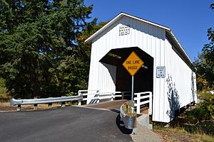
Parvin Bridge spans Lost Creek south of Dexter
|
|
|
Location of the mouth of Lost Creek in Oregon
|
|
| Country | United States |
| State | Oregon |
| County | Lane |
| Physical characteristics | |
| Main source | Cascade Range foothills near Mount June, between Dorena Lake and Lookout Point Lake 3,235 ft (986 m) 43°48′16″N 122°42′24″W / 43.80444°N 122.70667°W |
| River mouth | Middle Fork Willamette River downstream of Lowell 604 ft (184 m) 43°56′57″N 122°51′03″W / 43.94917°N 122.85083°W |
Lost Creek is a small stream in the state of Oregon, United States. It's like a smaller river that flows into a bigger one. Lost Creek joins the Middle Fork Willamette River.
This creek starts in the Cascade Range foothills. These are the lower hills of a big mountain range. It begins between two lakes, Dorena Lake and Lookout Point Lake. From there, it flows mostly north. It eventually meets the Middle Fork Willamette River near the town of Lowell.
Along its path, Lost Creek flows past the quiet community of Dexter. It also goes under Oregon Route 58, which is a main road. Part of the creek also runs through Elijah Bristow State Park, a nice place to visit. Several smaller streams, called tributaries, flow into Lost Creek. These include Guiley, Gossage, Carr, Middle, Anthony, and Wagner creeks.
Why Is It Called Lost Creek?
Have you ever wondered how places get their names? The book Oregon Geographic Names (OGN) tells us that the valley where Lost Creek flows was once known as "Lost Valley." This was back when the first settlers arrived in the area.
Another book, Illustrated History of Lane County, says that a person named Elijah Bristow gave the valley its name. OGN suggests that the name "Lost" probably came from how hidden or secluded the valley felt. It was a bit out of the way, making it seem "lost."
The Historic Covered Bridge
One of the most interesting features along Lost Creek is the Parvin Bridge. This is a special kind of bridge called a covered bridge. It's located south of Dexter.
The Parvin Bridge is 75 feet long and has only one lane. It carries Parvin Road over the creek. This historic bridge was built a long time ago, in 1921. Because of its importance and history, it was added to the National Register of Historic Places in 1979. This means it's a protected landmark.
 | Georgia Louise Harris Brown |
 | Julian Abele |
 | Norma Merrick Sklarek |
 | William Sidney Pittman |


