Lovett River facts for kids
Quick facts for kids Lovett River |
|
|---|---|

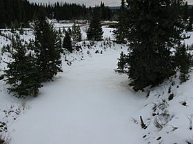
The Lovett River from Alberta Highway 734
|
|
| Country | Canada |
| Province | Alberta |
| Physical characteristics | |
| Main source | Lovett River Headwaters 1,427 m (4,682 ft) 53°04′41″N 116°53′59″W / 53.07806°N 116.89972°W |
| River mouth | Pembina River 1,330 m (4,360 ft) 52°59′11″N 116°38′20″W / 52.98639°N 116.63889°W |
The Lovett River is a short river located in the Alberta foothills of Canada. It is an early tributary (a smaller river that flows into a larger one) of the Pembina River. The Pembina River then flows into the much larger Athabasca River.
The Lovett River was once known as the Little Pembina River. Its name was changed to Lovett River to avoid confusion with the Pembina River. The new name comes from Lovettville, an old coal mining town that used to be nearby. This town was named after H. A. Lovett, who was the President of a mining company in the area called North American Collieries.
Where the River Flows
The Lovett River begins in the foothills south of a place called Coalspur, Alberta. It generally flows towards the southwest. Along its path, it goes under two main roads: Alberta Highway 40 and Alberta Highway 734.
The river flows through areas where coal is still mined today. It also passes by some smaller natural gas fields. You might also see places that were once busy coal mining towns but are now ghost towns (empty towns where no one lives anymore). Finally, the Lovett River flows into the Pembina River.
 | Charles R. Drew |
 | Benjamin Banneker |
 | Jane C. Wright |
 | Roger Arliner Young |

