Ludgine River facts for kids
Quick facts for kids Ludgine River |
|
|---|---|

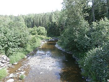
Rivière Ludgine downstream from Rang Ludgine in Lac-Drolet.
|
|
| Native name | Rivière Ludgine |
| Country | Canada |
| Province | Quebec |
| Region | Chaudière-Appalaches |
| MRC | Beauce-Sartigan Regional County Municipality, Le Granit Regional County Municipality |
| Physical characteristics | |
| Main source | Agricultural streams Saint-Hilaire-de-Dorset 478 metres (1,568 ft) 45°48′03″N 70°52′31″W / 45.800752°N 70.875256°W |
| River mouth | Chaudière River Saint-Ludger 315 metres (1,033 ft) 45°42′33″N 70°45′07″W / 45.70917°N 70.75195°W |
| Length | 15.9 kilometres (9.9 mi) |
| Basin features | |
| Progression | Chaudière River, St. Lawrence River |
| River system | St. Lawrence River |
| Basin size | 60.7 kilometres (37.72 mi) |
| Tributaries |
|
The Ludgine River (called rivière Ludgine in French) is a river in Quebec, Canada. It flows into the Chaudière River, which then joins the mighty St. Lawrence River.
The Ludgine River flows through different areas in Quebec. These include parts of the Beauce-Sartigan Regional County Municipality and the Le Granit Regional County Municipality. It passes through towns like Saint-Hilaire-de-Dorset, Lac-Drolet, and Saint-Ludger.
Where the River Flows
A river's watershed is all the land where water drains into that river. The Ludgine River has several important neighboring watersheds.
- To the north, you'll find the Petit Portage River and the rivière de la Grande Coudée.
- The Chaudière River is to the east and also to the south.
- The Drolet River is to the south.
- To the west, there's Drolet Lake and the rivière aux Bluets Sud.
The Ludgine River begins in a hilly area near the town of Saint-Hilaire-de-Dorset. This starting point is called its "source." It's about 478 meters (1,568 feet) above sea level.
From its source, the Ludgine River flows for about 15.9 kilometers (almost 10 miles). It generally flows towards the southeast. Along its journey, it crosses several roads and passes through different towns.
The river eventually flows into the Chaudière River in the town of Saint-Ludger. This meeting point is called the "confluence." It's located about 315 meters (1,033 feet) above sea level.
What's in a Name?
The name "Ludgine" is a girl's name of French origin.
For a long time, maps called this river the "Eugenie River." The name "Ludgine" might be a shorter, more common way to say "Ludger." Or, it could be a mix of "Ludger" and "Eugenie."
Another idea is that the name "Ludgine" came from an Indigenous woman named Eugénie. She lived near the river in Lac-Drolet. People think the English way of saying her name might have led to the spelling "Ludgine."
The official name "Rivière Ludgine" was made official on January 31, 1980. This was done by the Commission de toponymie du Québec, which is like a special committee for place names in Quebec.
 | James Van Der Zee |
 | Alma Thomas |
 | Ellis Wilson |
 | Margaret Taylor-Burroughs |


