Drolet River facts for kids
Quick facts for kids Drolet River |
|
|---|---|

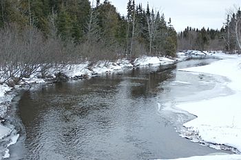
Drolet River downstream from the Rang 5 bridge to the east.
|
|
| Native name | Rivière Drolet |
| Country | Canada |
| Province | Quebec |
| Region | Estrie |
| MRC | Le Granit Regional County Municipality |
| Physical characteristics | |
| Main source | Drolet Lake Lac-Drolet 460 metres (1,510 ft) 45°43′43″N 70°51′31″W / 45.72857°N 70.858699°W |
| River mouth | Chaudière River Lac-Drolet 322 metres (1,056 ft) 45°41′31″N 70°47′12″W / 45.69194°N 70.78667°W |
| Length | 9.8 kilometres (6.1 mi) |
| Basin features | |
| Progression | Chaudière River, St. Lawrence River |
| River system | St. Lawrence River |
| Tributaries |
|
The Drolet River is a cool river in Quebec, Canada. It's also known as rivière Drolet in French. This river flows into the Chaudière River. The Chaudière River then travels north to join the mighty St. Lawrence River.
The Drolet River flows through the town of Lac-Drolet. This area is part of the Le Granit Regional County Municipality (MRC). It's located in the Estrie region of Quebec.
Contents
Where the Drolet River Flows
The Drolet River is surrounded by other rivers and lakes. Knowing these helps us understand its journey.
Nearby Waterways
Here are some of the main rivers and lakes close to the Drolet River:
- North side: Ludgine River, Petit Portage River, and rivière de la Grande Coudée.
- East side: The Chaudière River, which the Drolet River joins.
- South side: The Chaudière River again, and the Madisson River.
- West side: Drolet Lake, Lac du Rat Musqué, and Rivière aux Bluets Sud.
The River's Beginning
The Drolet River starts its journey from Drolet Lake. This lake is about 3.2 kilometres (2.0 mi) long. It sits at an elevation of 457 metres (1,499 ft) above sea level. Drolet Lake is in the town of Lac-Drolet.
You can find this lake near the Route des Sommets, a scenic road. The lake has a small island in the middle. This island is connected to a spot called "Pointe à Bénedict." Many vacation homes are built around the southwest and northern parts of the lake. It's located northwest of the village of Lac-Drolet.
The River's Path
From Drolet Lake, the Drolet River flows for about 9.8 kilometres (6.1 mi). Here's how its path unfolds:
- First part: It flows for 2.0 kilometres (1.2 mi) towards the southwest. During this part, it goes right through the village of Lac-Drolet. It crosses the road to Le Morne as it leaves the village.
- Second part: It then continues for 7.8 kilometres (4.8 mi) towards the southwest. It follows a small valley and the route of Le Morne. This part of the river leads to where it meets another river.
Where the River Ends
The Drolet River eventually flows into the Chaudière River. This meeting point is on the west bank of the Chaudière River. It's still within the municipality of Lac-Drolet. This spot is known as "Puits de Jacob."
The river's end point is about 0.9 kilometres (0.56 mi) west of Route 204. It's upstream from a bridge in the village of Saint-Ludger. It's also downstream from the border between Sainte-Cécile-de-Whitton and Lac-Drolet.
About the Name
The name "rivière Drolet" was officially recognized on December 5, 1968. This was done by the Commission de toponymie du Québec. This commission is in charge of naming places in Quebec.
 | Valerie Thomas |
 | Frederick McKinley Jones |
 | George Edward Alcorn Jr. |
 | Thomas Mensah |


