Lupton, Arizona facts for kids
Quick facts for kids
Lupton, Arizona
|
|
|---|---|

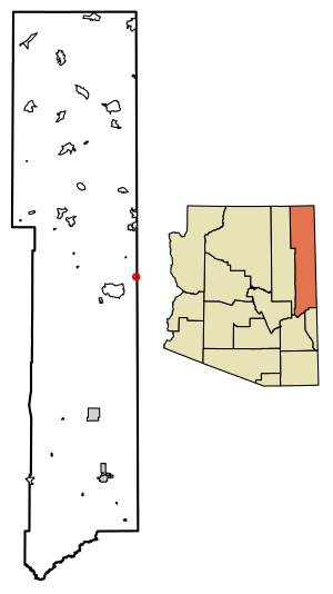
Location of Lupton in Apache County, Arizona.
|
|
| Country | United States |
| State | Arizona |
| County | Apache |
| Area | |
| • Total | 0.35 sq mi (0.90 km2) |
| • Land | 0.35 sq mi (0.90 km2) |
| • Water | 0.00 sq mi (0.00 km2) |
| Elevation | 6,188 ft (1,886 m) |
| Population
(2020)
|
|
| • Total | 19 |
| • Density | 54.60/sq mi (21.07/km2) |
| Time zone | UTC-7 (Mountain (MST)) |
| ZIP code |
86508
|
| Area code(s) | 928 |
| GNIS feature ID | 2582818 |
Lupton (which is called Navajo: Tsé Siʼání in the Navajo language) is a small place in Apache County, Arizona, United States. It is not a city or town, but a "census-designated place" (CDP). This means it's an area that the government counts for population, but it doesn't have its own local government.
Lupton is right on the border with New Mexico. It sits along Interstate 40, a major highway. It is about 21 miles (34 km) southwest of Gallup, New Mexico. Lupton has its own post office with the ZIP code 86508. In 2020, only 19 people lived in Lupton.
History of Lupton
Lupton was started in 1905. It was named after G. W. Lupton, who was a trainmaster. A trainmaster is someone in charge of how trains run on a railway.
A long time ago, in 1864, a military officer named Colonel John Washington traveled through this area. He was part of a campaign against the Navajo people.
Population and People
The United States government counts how many people live in different places every ten years. This is called a census.
- In 2020, the census showed that 19 people lived in Lupton.
Schools in Lupton
Children in Lupton go to schools that are part of the Sanders Unified School District.
See also
 In Spanish: Lupton (Arizona) para niños
 | Anna J. Cooper |
 | Mary McLeod Bethune |
 | Lillie Mae Bradford |


