Lyall Bay facts for kids
Quick facts for kids
|
|
|---|---|
|
Suburb
|
|

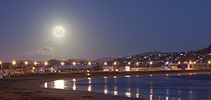
Full moon over the bay
|
|
| Country | New Zealand |
| Local authority | Wellington City |
| Electoral ward |
|
| Area | |
| • Land | 55 ha (136 acre) |
| Population
(June 2023)
|
|
| • Total | 2,690 |
| Airport(s) | Wellington International Airport |
|
|
||
Lyall Bay is a bay and suburb located in Wellington, New Zealand. It sits on the southern side of the Rongotai isthmus, which is a narrow strip of land connecting two larger landmasses.
This area is famous for its beautiful beach, which is a top spot for surfing. You'll find a breakwater (a wall built into the sea) at the eastern end. Lyall Bay is also home to two surf lifesaving clubs and has hosted many surf lifesaving championships. It's known as a safe and popular place for swimming. The beach used to be bigger, but about a third of it was used to build Wellington International Airport.
Lyall Bay is mostly a place where people live. It also includes parts of Wellington's Southern Walkway and the Southern Headlands Reserve, which are great for outdoor activities. The suburb has good bus services and is close to the Kilbirnie shopping centre. You can also find a primary school, a Playcentre, a lawn bowls club, churches, and some local shops here. The well-known Wellington band, Fat Freddy's Drop, also calls Lyall Bay home.
Scientists believe Lyall Bay was once the mouth of the Hutt River. The land you see today was formed by big changes in the Earth, especially from earthquakes. Two major earthquakes, the Haowhenua earthquake in the 1400s and the 1855 Wairarapa earthquake, lifted the land. The 1855 earthquake even caused a tsunami that swept over the land between Lyall Bay and Evans Bay, leaving fish stranded in the sand dunes!
Contents
What's in a Name? Lyall Bay's History
Lyall Bay was once called False Bay. This was because ships would sometimes mistake it for the entrance to Wellington Harbour.
The Māori name for the beach was Hue te para. This name means 'gourd', 'the', and 'ripe'. An early map from 1919 showed this name. However, some Māori people at the time did not know this name.
There are different ideas about who Lyall Bay is named after. Some think it's named after Dr David Lyall from the survey ship HMS Acheron. But the name Lyall Bay was already being used before he served on that ship. Another idea is that it's named after George Lyall, who was a director of the New Zealand Company. Old records sometimes spell it as Lyell Bay. This has led some to believe it was named after the famous geologist Charles Lyell.
Lyall Bay's Past: A Growing Suburb
The suburb of Lyall Bay was first called Maranui. In 1896, H D Crawford and H M Hayward started selling sections for a new town here. Maranui School, now known as Lyall Bay School, opened in 1909.
The area grew slowly at first. But in December 1909, the City Council extended the tram line down Onepu Road to the beach. This made it much easier for people to visit. Soon, Lyall Bay became a popular spot for day trips, especially on weekends, and the suburb grew quickly.
Battling the Sand: Lyall Bay's Challenges
Most of the early development in Lyall Bay was on the western side. The eastern side had many sand dunes. The tram line was often covered by sand blowing across the road.
To fix this, the Wellington City Council started a project in 1925. They leveled the dunes and covered much of the area with clay. This helped to hold the sand in place. In 1932, the Council built a special sea wall along the beach. It was designed to blow sand back onto the beach, instead of letting it drift over the road.
In the late 1930s, a lot of sand and gravel built up on the beach. From the 1940s to the 1960s, the Council paid people to remove it. This caused the beach to wear away badly. By 1961, the beach level near the surf lifesaving clubs was about 1 meter lower than before. At high tide, there was almost no beach left.
Residents blamed the removal of sand and the new breakwater near the airport for changing the currents. The Council said they removed the material carefully and that the erosion was natural. People living at the eastern end of the bay, where there was no sea wall, also had problems with sand drifting. So, in 1975, the Council built another sea wall extending from Onepu Road.
Since 1990, the Council has been working to restore the sand dunes at the eastern end of Lyall Bay beach. They fenced off part of the dunes and built boardwalks for beach access. Thousands of native plants like pingao were planted to help keep the sand from moving.
Airport Expansion: Changing the Bay
In 1935, the Wellington City Council decided to build an airport at Rongotai. This plan involved filling in about 10.5 hectares of the seabed at the eastern end of Lyall Bay. Some of this work began in 1940, using dirt from Moa Point Hill.
By 1950, the plans included more reclamation in Lyall Bay. By 1954, the work was in full swing. A breakwater was built, and Moa Point Hill was completely flattened. The dirt from the hill was pushed into Lyall Bay. In total, about a third of the bay was filled in to create space for the airport, which opened in 1959.
Surfing at Lyall Bay
People have been enjoying surfing at Lyall Bay for over 100 years! Surfing became very popular after Duke Paoa Kahanamoku from Hawaii visited in March 1915. He showed off his surfing skills to a huge crowd.
The eastern end of the beach is known as Surfers Corner. The waves there are called The Corner. These waves are affected by the breakwater that was built when Wellington Airport was created in the 1950s.
In 2015, the Airport announced plans to make its runway longer. Surfers worried this would harm the waves in the bay. The airport said they would build an artificial reef about 500 meters offshore to help the waves. As of 2023, the runway has not been extended, and the reef has not been built.
Surf Lifesaving: Keeping Swimmers Safe
Lyall Bay is home to two important surf lifesaving clubs: the Lyall Bay Surf Lifesaving Club and the Maranui Surf Lifesaving Club. The Lyall Bay club started in 1910. After a disagreement, some members left in 1911 to form the Maranui club.
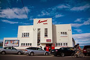
In 2021, the Lyall Bay club opened a new clubhouse. It replaced their old building from 1957. The new building has space for club activities, storage, toilets, changing rooms, and outdoor showers for public use. The Maranui SLSC's building was built in 1930. It has been changed over the years, and in 2005, the Maranui cafe opened on its top floor.
Volunteers from the Lyall Bay club watch over the beach during the summer. Maranui club members patrol Oriental Bay. Members from both clubs compete in surf sports events across the country. Sometimes, these competitions are even held at Lyall Bay.
Lyall Bay Community: People and Education
Lyall Bay is a lively community. In 2018, about 2,673 people lived there. The area is about 0.55 square kilometers. The median age of residents was 36.5 years. About 18% of the people were under 15 years old.
Most people living in Lyall Bay are of European descent (71.2%). There are also significant Māori (13.0%), Pasifika (8.5%), and Asian (16.8%) communities. About 27.7% of the people living in Lyall Bay were born overseas.
Many people in Lyall Bay have higher education. About 37.9% of adults had a bachelor's degree or higher. The median income was $39,600.
Lyall Bay School
Lyall Bay School is a primary school for students in Year 1 to Year 6. It is a co-educational state school, meaning both boys and girls attend, and it is funded by the government.
 | Sharif Bey |
 | Hale Woodruff |
 | Richmond Barthé |
 | Purvis Young |


