Lydia, South Carolina facts for kids
Quick facts for kids
Lydia, South Carolina
|
|
|---|---|
| Country | United States |
| State | South Carolina |
| County | Darlington |
| Area | |
| • Total | 2.64 sq mi (6.85 km2) |
| • Land | 2.64 sq mi (6.85 km2) |
| • Water | 0.00 sq mi (0.00 km2) |
| Elevation | 213 ft (65 m) |
| Population
(2020)
|
|
| • Total | 572 |
| • Density | 216.42/sq mi (83.56/km2) |
| Time zone | UTC-5 (Eastern (EST)) |
| • Summer (DST) | UTC-4 (EDT) |
| ZIP code |
29079
|
| FIPS code | 45-43135 |
| GNIS feature ID | 2629835 |
Lydia is a small community in Darlington County, South Carolina, United States. It used to be called Mount Elon. It is known as a census-designated place (CDP). This means it's an area that the government counts for population, but it's not officially a city or town.
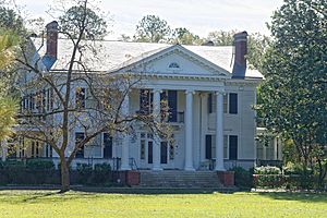
In 2020, about 572 people lived in Lydia. It is also home to the Lydia Plantation, a special historical place. This plantation is listed on the U.S. National Register of Historic Places.
Lydia is located in the western part of Darlington County. It's very close to the border of Lee County. A main road, U.S. Route 15, goes through the community. This road can take you northeast about 7 miles (11 km) to Hartsville. Or, if you go southwest, it's about 10 miles (16 km) to Bishopville. Another road, South Carolina Highway 34, goes east about 14 miles (23 km) to Darlington. Darlington is the main town, or county seat, for the area.
Geography of Lydia
Lydia covers an area of about 2.64 square miles (6.8 square kilometers). All of this area is land. There are no large bodies of water like lakes or rivers within the community's boundaries.
Population of Lydia
The population of Lydia is counted by the U.S. Census Bureau every ten years. This count helps us understand how many people live in different places.
- In 2020, the population was 572 people.
- In 2010, the population was 642 people.
See also
 In Spanish: Lydia (Carolina del Sur) para niños
 | Delilah Pierce |
 | Gordon Parks |
 | Augusta Savage |
 | Charles Ethan Porter |


