
Machrihanish Bay facts for kids
Quick facts for kids Machrihanish Bay |
|
|---|---|

Machrihanish Bay with headland of Machrihanish village.
|
|

Machrihanish Bay
Location in Argyll and Bute
|
|
| Location | Argyll and Bute, Scotland |
| Coordinates | 55°26′07.9296″N 5°44′1.1364″W / 55.435536000°N 5.733649000°W |
| Ocean/sea sources | Atlantic Ocean |
| Basin countries | Scotland |
| Max. length | 4 mi (6.4 km) |
| Max. width | 3 mi (4.8 km) |
| Average depth | 40 ft (12 m) |
Machrihanish Bay is a large, quiet bay on the west coast of Scotland. It is located in a region called Argyll and Bute. The bay sits right next to Campbeltown Airport.
This beautiful bay is part of the Kintyre peninsula. Machrihanish Bay is special because it has the longest continuous sandy beach in all of Argyll. It stretches for about 4 miles (6.4 km) along the coast.
Contents
Nearby Places and Villages
Machrihanish Bay has a few interesting places nearby. The closest village is also called Machrihanish. It sits on a piece of land that sticks out into the sea, at the southern end of the bay.
Campbeltown Airport
Right next to the bay, to the east, is Campbeltown Airport. This airport used to be a Royal Air Force (RAF) base. It is still an important place for travel in the area.
Other Settlements
Further east, across the peninsula, is the town of Campbeltown. It's about 3 nautical miles (5.6 km) away from the bay. To the north of the airport, near the bay's northern shore, you'll find the small village of West Darlochan.
Roads Around the Bay
The main road, the A83, follows the west coast of the Kintyre peninsula. When it reaches the north side of Machrihanish Bay, it turns east. This road goes through small villages like Kilchenzie and Drumore. It eventually leads to Campbeltown. Another road, the B842, leaves Campbeltown and heads west. It passes through Stewarton before reaching the bay as the B843 road.
Geography of the Bay
Machrihanish Bay is surrounded by interesting natural features. To the north, about 2.3 nautical miles (4.3 km) away, is another bay called Bellochantuy Bay.
Southern Features
To the south of Machrihanish Bay, about 1 nautical mile (1.9 km) away, is Earadale Point. This is where the Kintyre peninsula starts to curve inwards. South of the bay, you can see a forested hill called The Slate. Further northeast, about 4 miles (6.4 km) away, is a larger hill named Cnoc May. This hill offers great views overlooking the bay.
Machrihanish Water
A river called Machrihanish Water flows into the bay. Rivers often carry fresh water and nutrients into bays, which can be important for local wildlife.
Images for kids
-
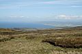
Machrihanish Bay. Looking on from Cnoc Moy.
-
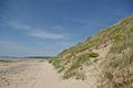
Beach & dunes at Machrihanish Bay.
-
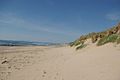
Beach & dunes.
-
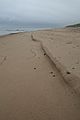
Beach at Machrihanish Bay, looking north.
-
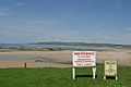
Information boards at Machrihanish Bay


