
Magos, San Sebastián, Puerto Rico facts for kids
Quick facts for kids
Magos
|
|
|---|---|
|
Barrio
|
|

Cuesta de Magos is a long, steep, narrow, curvy section of PR-438 that leads down to Río Culebrinas in Magos.
|
|

Location of Magos within the municipality of San Sebastián shown in red
|
|

Magos, San Sebastián, Puerto Rico
Location in Caribbean
|
|
| Commonwealth | |
| Municipality | |
| Area | |
| • Total | 1.42 sq mi (3.7 km2) |
| • Land | 1.42 sq mi (3.7 km2) |
| • Water | 0 sq mi (0 km2) |
| Elevation | 804 ft (245 m) |
| Population
(2010)
|
|
| • Total | 232 |
| • Density | 163.4/sq mi (63.1/km2) |
| Source: 2010 Census | |
| Time zone | UTC−4 (AST) |
Magos is a small community, also known as a barrio, located in San Sebastián, Puerto Rico. In 2010, about 232 people lived there. It's a quiet place with some beautiful natural spots.
Contents
A Look Back in Time
After the Spanish–American War, Spain gave Puerto Rico to the United States in 1898. This happened because of a special agreement called the Treaty of Paris of 1898. Puerto Rico then became a territory of the United States.
In 1899, the United States Department of War counted all the people in Puerto Rico. They found that Magos and a nearby barrio called Eneas had a combined population of 1,003 people.
| Historical population | |||
|---|---|---|---|
| Census | Pop. | %± | |
| 1980 | 215 | — | |
| 1990 | 261 | 21.4% | |
| 2000 | 242 | −7.3% | |
| 2010 | 232 | −4.1% | |
| U.S. Decennial Census 1899 (shown as 1900) 1910-1930 1930-1950 1980-2000 2010 |
|||
What are Sectors?
Barrios like Magos are usually divided into even smaller areas. These smaller areas are called sectores (which means sectors in English). Think of them as neighborhoods within a larger community.
Sectors can have different names. Some are simply called sector, while others might be called urbanización, reparto, barriada, or residencial.
Sectors in Magos
Here are some of the sectors you can find in Magos barrio:
- Carretera 438
- Carretera 451
- Carretera 470
- Sector Ballester
- Sector La Cuadra
- Sector Melito Oliva
- Sector Miguel A. Pérez
- Sector Puente Lajas
- Sector Pujols
- Sector Sonoco
- Sector Toño Jiménez
- Urbanización Santa Teresita
The Culebrinas River
There is a bridge on Highway PR-438 that crosses over the Culebrinas River in Magos. This river is an important part of the area. Sometimes, when there is a lot of rain, the river can flood. When this happens, the road over the bridge has to be closed to keep everyone safe.
Gallery
-
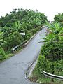
At bottom of Cuesta de Magos near Río Culebrinas
-
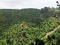
Cuesta de Magos as seen from barrio Calabazas, San Sebastián
-
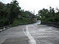
Slanted bridge at bottom of hill, on PR-438 over Río Culebrinas in barrio Magos
-
Cuesta de Magos in barrio Magos, PR-438
-
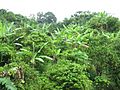
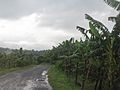
Vegetation and fruit trees at bottom of "Magos Hill"


See also
 In Spanish: Magos (San Sebastián) para niños
- List of communities in Puerto Rico
- List of barrios and sectors of San Sebastián, Puerto Rico
