
Maidenhead Waterways facts for kids
The Maidenhead Waterways are a system of canals in Maidenhead, England. These waterways used to be old and not used much. However, in 2011, plans were announced to bring them back to life! The goal is to make them ready for small boats first, and then for bigger boats over time.
The waterways flow south from the River Thames near Cliveden. The main channel splits into two parts: York Stream and Moor Cut. York Stream goes under the old Chapel Arches, while Moor Cut crosses Town Moor. These two channels meet again at Green Lane. From there, they become Bray Cut, which then flows back into the Thames near Bray Marina. Since it's a side channel of the Thames, people always have the right to use it for boats.
Contents
History of the Waterways
The flat land between Cookham and Windsor has many old waterways. Over time, these channels were used for different things. They served as boundaries, helped drain water, powered mills, and some parts were even used for boats.
The waterways that run through Maidenhead town centre today used to be much wider. You can tell this by looking at the size of the old buildings and structures built over them. A long time ago, during the Regency period, the main waterway was known as The Canal.
Brunel's Tunnels
Around 1838, the famous engineer Isambard Kingdom Brunel built two sets of strong tunnels. There were eight tunnels in total! These tunnels safely carried the water under his Great Western Railway line. Maps from 1899 show that Chapel Arches had water flowing through three large arches. There was also a big lake at Ives Place, where the town's library is now.
Old Locks and Barges
Before today's modern locks were built on the main River Thames, the old waterways used "flash locks." These were like gates or weirs with parts that could be removed. People believe that barges, which are flat-bottomed boats, once operated from wharves (loading areas) on both the main river and its side channels.
Some parts of the waterway were actively used until at least the 1920s. People remembered seeing reeds being cut for roof thatch. They also saw timber being unloaded from a barge at Willow Wharf. This wharf was in the Moor Cut channel on Town Moor. A business directory from 1939 listed a builders' merchant, "Grace C.W.& Co," operating from Willow Wharf in Bridge Street. You can still see the old signs for Graces on the channel wall near the Police station at Town Moor.
Flood Protection Changes
In the 1960s, the channel crossing Town Moor was made wider. This was part of the flood protection system at the time. Later, the Jubilee River was finished in 2002. This new river helped protect Maidenhead from floods, making the older flood defence system not needed anymore.
The two channels, York Stream and Moor Cut, meet again at Green Lane. From there, the waterway flowing down to the Thames is already quite wide, about 14 to 15 meters (45 to 50 feet). However, it was very overgrown and filled with silt (mud). In recent years, volunteers have worked hard to clear most of the fallen trees. Now, canoes and rowing boats can use it, though there are still some challenges.
The York Stream channel in the centre of Maidenhead had become narrow and shallow. It would sometimes dry out when the main River Thames, which feeds it, had low water levels. The Moor Cut channel, which was part of the old flood protection, was usually kept dry unless there was a flood.
Bringing the Waterways Back to Life
By October 2008, a big plan was underway to restore and improve the old waterways. The goal was to allow boats to travel into the centre of Maidenhead. The Maidenhead Waterways Group (MW) was started in 2006. In March 2007, it became a charity. Their aim was to make the waterways navigable again. This would allow boats to travel into and around the town centre's 'Ring' of water.
A lock and weir were planned for Green Lane. This would raise and keep the water levels steady in the town centre channels. It would also permanently fill the usually dry Moor Cut channel.
Town Centre Plans
The Royal Borough of Windsor and Maidenhead (the local council) created a group called the Partnership for the Rejuvenation of Maidenhead (PRoM) in December 2007. This group developed a 20-year plan to make the town centre better. This plan was approved in September 2011. It saw the restored waterway as one of the most important projects. It would help improve and shape the town's identity for the future.
The plan also found areas where new homes and offices could be built. Three of these areas were right next to the waterways. They would look much nicer with a pleasant water view. These areas included High Street and York Stream, York Road, and Stafferton Way.
New building projects often contribute money to help build community facilities. This money is called "Section 106 money." The first of these projects was the Chapel Arches scheme. The developer, Shanly Homes, built three developments there: Waterside Quarter, The Picturehouse, and Chapel Wharf. These included 259 homes and 30,000 square feet (2,787 square meters) of shops and offices.
Building the Waterways
Maidenhead Waterways asked for permission to start Phase 1 of the works in August 2011. Permission was given in December 2012, with some rules. These rules included making detailed plans for how the waterways would be managed. The project also had to be finished within five years of starting.
It was hoped that money would come from donations, government grants, lottery funding, and Section 106 money from developers. The project then moved to the detailed design stage, while also looking for funding. By 2014, the project was split into three main stages, with the middle stage having three parts.
The Council chose a contractor, Greenford Ltd, in November 2014. They were given a contract for £2.63 million to cover Stage 1. Work on this first stage began in early 2015. The flow of York Stream was temporarily sent down the usually empty Moor Cut channel in February. This allowed York Stream to dry out so work could begin.
No external funding from the government or lottery was received. So, the work was first paid for by a loan fund from the Thames Valley Local Enterprise Partnership. Then, it was funded by Section 106 money from new developments in the town centre.
Recent Progress
In December 2015, the Royal Borough of Windsor and Maidenhead announced it would provide £3 million. This money would fund the next stage of building. It would allow the 0.6-mile (1-kilometer) long York Stream part of Maidenhead's waterway 'Ring' to be finished. This included building a weir with a fish pass and boat rollers at the southern end. This would raise the water level throughout the town centre.
Shanly Homes also helped pay for the waterway. They built an outdoor seating area by the water near the Library. It has about 200 seats for public use. They also built a new footbridge over the channel.
Phase 1, including the weir, fish pass, and landscaping, was finished in March 2020. This means small boats can now use the York Stream half of the ring. Shanly Homes completed their Picturehouse and Chapel Wharf developments. The third phase, Waterside Quarter, was expected to be finished in 2021. This would complete the final linking section of the York Stream arm of the waterway 'Ring'. An access ramp and floating platforms (pontoons) at Chapel Arches will allow boats to be loaded. They will also provide storage for canoes and small boats in the two western arches.
A short video about the project was made in 2018, introduced by Theresa May. In 2019, the project won a special award in the national Canal and River Trust's Living Waterways competition. This trust also made a video about the project.
The first finished section was officially opened by Theresa May on March 14, 2020. A weir has been built at Green Lane. It has boat rollers instead of a lock, so small boats can be launched. The weir raises the water depth to 4.25 feet (1.3 meters). The western channel, York Cut, can be used by boats as far as Chapel Arches bridge. So far, the project has cost £8 million. This money came from Windsor and Maidenhead Council and Section 106 money from the two developers, Shanly and Countryside.
Moor Cut is still quite shallow, except near its southern end where it joins York Stream. Its bed will be made deeper as part of Stage 3 work. Maidenhead Waterways will be looking for money to improve the southern channel, Bray Cut. This channel already connects the 'Ring' to the River Thames at Bray Marina. This channel was made wider in the 1960s for flood protection. However, it has filled with silt and is very overgrown.
Waterway Route
The full waterway route starts at the Thames near Cliveden Reach. It flows through the White Brook (also called Widbrook) across Cookham Moor. It is fed by a small stream known as Fleet Ditch. Then it joins Strand Water.
It then flows south as Maidenhead Ditch until it splits at Town Moor. Here it becomes York Stream and Moor Cut. York Stream goes west through Maidenhead town centre. The Moor Cut channel to the east was usually dry. Its old role in flood protection was taken over by the Jubilee River scheme.
The two sections meet again at Green Lane. From there, they become a channel known as The Cut. It's also called Bray Cut to tell it apart from the main section of The Cut, Berkshire. This channel flows into the River Thames at Bray Marina.
The footpath that follows the existing north-south (York Stream) waterside path is called "The Green Way." As part of the approved plan, a second footpath will be built along the hidden Moor Cut channel. This will complete a waterside path all the way around the finished 'Ring'.
Water Quality
The Environment Agency checks the water quality of river systems in England. Each waterway is given an overall "ecological status." This status can be one of five levels: high, good, moderate, poor, or bad. Many things are used to decide this. These include the "biological status," which looks at the number and types of small creatures, plants, and fish. There's also "chemical status," which checks the amount of different chemicals against safe levels. Chemical status is rated as good or fail.
Here's how the water quality of the Maidenhead Waterways system was in 2016:
| Section | Ecological Status |
Chemical Status |
Overall Status |
Length | Catchment | Channel |
|---|---|---|---|---|---|---|
| Maidenhead Ditch | Moderate | Fail | Moderate | 4.3 miles (6.9 km) | 8.71 square miles (22.6 km2) | heavily modified |
| Cut (Binfield to River Thames) and Maidenhead Ditch | Moderate | Fail | Moderate | 10.7 miles (17.2 km) | 25.91 square miles (67.1 km2) |
The water quality was less than good for a few reasons. These included dirty water from sewage going into the waterways. Also, physical changes made to the channel created barriers for fish to move freely. The chemical status of the waterways improved from "Fail" in 2013 and 2014 to "Good" in 2015 and 2016. However, between 2016 and 2019, it went back to "Fail." The Environment Agency calls the section above Green Lane "Maidenhead Ditch." The lower section is grouped with the lower parts of The Cut.
Images for kids
-
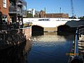
A view of Chapel Arches looking North.
-
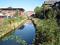
York Road Channel
-

Confluence of Moor Cut and York Stream with weir near Green Lane.


