
Main-Tauber-Kreis facts for kids
Quick facts for kids
Main-Tauber
|
|||
|---|---|---|---|
|
|||
| Country | |||
| State | Baden-Württemberg | ||
| Adm. region | Stuttgart | ||
| Capital | Tauberbischofsheim | ||
| Area | |||
| • Total | 1,304.4 km2 (503.6 sq mi) | ||
| Time zone | UTC+1 (CET) | ||
| • Summer (DST) | UTC+2 (CEST) | ||
| Vehicle registration | TBB, MGH | ||
| Website | http://www.main-tauber-kreis.de | ||


The Main-Tauber-Kreis is a district in the northeast part of Baden-Württemberg, Germany. It's a bit like a county in other countries.
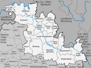
This district has several neighbors. To the northwest, you'll find Miltenberg. Moving clockwise, it borders Main-Spessart, Würzburg, Neustadt (Aisch)-Bad Windsheim, and Ansbach. All of these are in Bavaria. It also borders the districts of Schwäbisch Hall, Hohenlohe, and Neckar-Odenwald.
Contents
A Look at History
The Main-Tauber district was created in 1973. This happened when the old districts of Bad Mergentheim and Tauberbischofsheim joined together. Parts of the Buchen district also became part of this new area.
At first, it was called the Tauber district. But in 1974, it got its current name, Main-Tauber. This name comes from the two main rivers that flow through the area: the Main and the Tauber.
Where is Main-Tauber?
The Main River forms the northern edge of the district. The Tauber River, which is a smaller river flowing into the Main, runs through the district. It flows from the southeast towards the north.
The northern part of the district includes some of the Odenwald mountains. The southern area of the district is known as Bauland.
Understanding the Coat of Arms
The coat of arms for Main-Tauber-Kreis tells a story about its past. It shows symbols from three historical areas that once controlled this land.
A large part of the district used to be under the rule of the Bishopric of Würzburg. This was an area governed by a bishop until 1803. The red and white field with three peaks on the coat of arms represents Würzburg. This design was originally the symbol of Franconia, a historical region.
The wheel on the coat of arms is a symbol of the Archbishopric of Mainz. This was another important church territory. The cross on the coat of arms stands for the Teutonic Order. This was a powerful group of knights from history.
Towns and Communities
Here are the main cities and communities in the Main-Tauber district:
| Cities | Administrative Districts | Communities |
|---|---|---|
|
|
|
See also
 In Spanish: Distrito de Main-Tauber para niños
