Parish of Majura facts for kids
Quick facts for kids Majura ParishNew South Wales |
|||||||||||||||
|---|---|---|---|---|---|---|---|---|---|---|---|---|---|---|---|

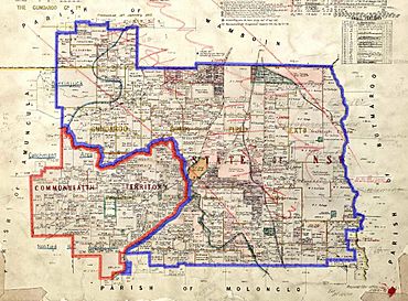
1924 cadastral map with highlights: Boundary of Majura parish since 1909 The eastern tip of the ACT, which was formerly part of the parish; transferred to the Commonwealth in 1909
|
|||||||||||||||
| LGA(s) | Queanbeyan-Palerang Regional Council | ||||||||||||||
| County | Murray | ||||||||||||||
| Division | Eastern | ||||||||||||||
|
|||||||||||||||
Majura Parish is a special kind of land division in New South Wales, Australia. Think of it like a specific area on a map used for keeping track of land ownership and boundaries. It's part of Murray County, New South Wales, which is a larger region.
This parish is located just east of the very edge of the ACT. Important transport routes, like the Queanbeyan-Bungendore railway line and the Kings Highway, both pass through this area.
A Changing Map: Majura's History
A long time ago, in 1909, about a quarter of Majura Parish was given to the Commonwealth to become part of the new ACT. This land was located between the railway line in the south and the high ground (called a watershed) near the Molonglo River in the north. A watershed is an area of land where all the water drains into a specific river or lake.
The Majura Exclave
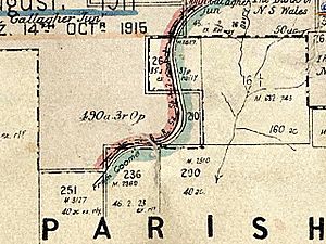
This change in the border created something interesting: a small part of Majura Parish, called portion 210, was cut off from the rest of the parish. This separated piece of land is known as an exclave. An exclave is a piece of land that belongs to one area but is completely surrounded by another area.
Majura Parish Today
When the land was transferred to the ACT, Majura Parish was part of a local government area called Yarrowlumla Shire. Today, it falls under the control of the Queanbeyan-Palerang Regional Council. This council helps manage local services and planning for the area.
 | Leon Lynch |
 | Milton P. Webster |
 | Ferdinand Smith |


