
Makapuʻu facts for kids

Makapuʻu is a beautiful area at the very eastern end of the island of Oʻahu in the Hawaiian Islands. It's known for its tall ridge that rises 647 feet (197 m) above the ocean. At Makapuʻu Point, you'll find a famous lighthouse. The name Makapuʻu means "bulging eye" in the Hawaiian language. People think this name came from an old image once found in a cave here. The whole area is very pretty, and you can see amazing views from the lookout on Kalanianaole Highway (State Rte. 72).
You can get to Makapuʻu by driving about 2 kilometers (1.2 mi) east from Waimānalo Beach on Kalanianaole Highway (State Rte. 72). Or, you can come from the Honolulu side (south shore, near Hawaiʻi Kai) by traveling east on the same highway past Sandy Beach. The Makapuʻu Point State Wayside Park is a 38-acre (15 ha) park right by the road.
Contents
Exploring Makapuʻu
There are many interesting places to visit and things to do in the Makapuʻu area.
Sea Life Park Hawaii

Sea Life Park Hawaii is a big park and aquarium. Here, you can see many kinds of Hawaiian marine life. They have fun shows and displays that teach you about the ocean and its creatures.
Makapuʻu Point Lighthouse
The Makapuʻu Point Lighthouse is a 46-foot-tall (14 m) lighthouse. It has been helping ships since 1909. The lighthouse was built after a ship called the Manchuria got stuck on the reefs near Waimānalo in 1906. In 1974, the lighthouse became automated, meaning it runs by itself without people living there.
The Giant Lens
This lighthouse has a very special lens. It's a French Fresnel hyper-radial lens that is about 12-foot-tall (3.7 m). It's the largest lens used in any lighthouse in the United States. This huge lens can make a single 1,000-watt light bulb shine very brightly and far out to sea. Even though it was once damaged by a bullet, the lens still works because it's so unique that it can't be replaced.
Hiking to the Lighthouse
A popular hike leads along the road to the lighthouse. You can start this walk from a parking lot south of the Makapuʻu lookout on Kalanianaole Highway. The lighthouse itself is not open to the public and is protected by gates.
Makapuʻu Point State Wayside
This park covers the eastern part of Oʻahu, including Makapuʻu Head and the lighthouse. A paved road, open only for walking, goes out to the Makapuʻu Lighthouse. The trail is about 1.75 miles (2.82 km) long. As you walk, you can see amazing views. From the top, you might even spot the islands of Molokaʻi and Lanaʻi across the Kaiwi Channel. On very clear days, you might even see Maui.
Whale Watching
If you visit between November and April, you might see Humpback whales swimming in the ocean offshore. There's a telescope at the lookout point for public use. You can also sometimes see blowholes along the rocky shore below Makapuʻu Head. These are places where ocean waves push water up through holes in the rocks, making a spray.
Mānana Island (Rabbit Island)
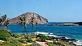
Mānana Island is a 63-acre (25 ha) island made from a tuff cone. People call it Rabbit Island because it looks like a big rabbit's head sticking out of the sea. It also used to have rabbits living on it! Today, the island is a protected bird sanctuary. This means it's against the law to land there without special permission from the Hawaii Department of Land Natural Resources.
Kāohikaipu Islet
Kāohikaipu is a small volcanic island located near Makapuʻu Beach Park. It is also a State Bird Sanctuary, protecting many seabirds.
Makapuʻu and Kaupō Beach Parks

All the rocky shoreline and small beaches between the cliffs at Makapuʻu Point and the State Research Pier (Makai Pier) are open to the public. The waves at Kaupō Beach (the western end) are usually calmer, which is better for younger swimmers or those who are not strong swimmers. Makapuʻu Beach is a popular spot for body-surfing, but the waves can be powerful and dangerous close to shore.
Makai Pier
The Makai Pier is a long, concrete pier built by the State of Hawaiʻi. It helps with marine research in the Hawaiian Islands. Several companies that work with ocean engineering are located here, along with the Hawaiʻi Underwater Research Laboratory (HURL).
Ka Iwi State Scenic Shoreline
This beautiful coastal area stretches from Makapuʻu Point Wayside all the way to Sandy Beach. In this area, you can find a rock formation called Pele's Chair. There's also a beach and swimming spot with the same name.
Images for kids
-
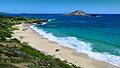
Makapuʻu Beach and Waimānalo Bay
-
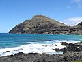
Makapuʻu Point and lighthouse from Makapuʻu Beach
-
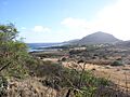
View of the Ka ʻIwi wilderness area from trail to Makapuʻu Point summit
-
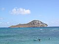
"Rabbit" Island: the emerging lop-eared rabbit is swimming to the right
-
The islands across Makapuʻu


