
Malé facts for kids
Quick facts for kids
Malé
މާލެ
|
|
|---|---|
| Malé City | |
|
Skyview of Malé
Muliaage
Gadi Buru
Friday Mosque
Malé Waterfront
|
|

Malé
Location in Maldives

Malé
Location in Asia
|
|
| Country | |
| Geographic atoll | North Malé Atoll |
| Government | |
| • Type | Mayor-council |
| • Body | Malé City Council |
| Area | |
| • Capital city | 11.22 km2 (4.33 sq mi) |
| • Urban | 1.95 km2 (0.75 sq mi) |
| • Metro | 9.27 km2 (3.58 sq mi) |
| Metro area also includes Hulhulé and Hulhumalé. | |
| Elevation | 2.4 m (7.9 ft) |
| Population
(2022)
|
|
| • Capital city | 211,908 |
| • Density | 18,887/km2 (48,916/sq mi) |
| Time zone | UTC+5 (MVT) |
| Assigned Letter |
T
|
| Area code(s) | 331, 332, 333, 334 |
| ISO 3166 code | MV-MLE |


.jpg)

.jpg)
Malé is the capital and largest city of the Maldives. In 2022, it had a population of over 211,000 people. This makes Malé one of the most crowded cities in the world. It is located at the southern edge of the North Malé Atoll, which is part of the Kaafu Atoll.
The city is made up of a main island, an airport island, and four other islands. These islands are all managed by the Malé City Council. Long ago, Malé was known as the King's Island. This is where the old royal families lived and ruled. The city used to have walls and forts around it. Most of these old buildings were removed in 1968 when the country changed its government. However, some important buildings, like the Malé Friday Mosque, still stand. In recent years, the island has grown a lot thanks to land reclamation, which means adding new land to the sea.
Contents
About Malé City

Even though Malé is geographically in the Kaafu Atoll, it is managed separately. It is its own special administrative area.
Islands that make up Malé City
Malé City includes several islands:
- Malé Central Island (the main island)
- Hulhulé (where the airport is)
- Hulhumalé (a newer, artificial island)
- Vilimalé
- Thilafushi
- Gulhifalhu
The main island of Malé is very busy and developed. It has a large commercial harbour, which is the center for all business in the Maldives. The main airport, Velana International Airport, is on Hulhulé Island.
Almost all of the main Malé island is covered with buildings. About one-third of the entire country's population lives here. The population grew from 20,000 in 1987 to 100,000 in 2006. Many people from other parts of the Maldives, and foreign workers, come to Malé. This is because it is the center for government and business. Most people in Malé live in small houses or apartments, often sharing with family or friends. This led to the creation of new islands like Hulhumalé to provide more space.
Many people from India and Bangladesh live and work in the Maldives. They work in construction, healthcare (as doctors and nurses), and education (as teachers). They also work as skilled and unskilled laborers, helping to build and run the country.
History of Malé
The name "Maldives" actually comes from its capital city. It means "the islands (dives) of Malé."
The first people to settle in the Maldives were from areas like modern-day India and Sri Lanka. Their culture and language have had a big impact on Maldivian society, especially in Malé. The Giraavaru people, who are one of the oldest groups in the Maldives, say they are descended from these early settlers.
It is said that early settlers called the islands Maalaitivu, meaning "Garland Islands" or "Chain Islands." The island of Malé itself was once called "Athamana Huraa." A local story says that Giraavaru fishermen used to clean tuna fish on a large sandbank. The water around it would turn red from the fish blood. This led to the name "Maa-le," which means "big blood" (maa for big, lē for blood). The Giraavaru people originally lived simply, led by local chiefs, without kings.
One day, a prince named Koimala arrived from another land on a large ship. The Giraavaru people welcomed him. They let him settle on the sandbank where the fish blood had stained the water. Trees were planted there, and the first tree was said to be a papaya tree. Over time, the local islanders accepted Prince Koimala as their ruler. A palace was built, and the island was officially named Malé. The island next to it was named Hulhulé.
The four main areas of Malé Island are said to have been named by the original Giraavaru fishermen. For example, Maafannu means "big place where a village path meets the sea."
In old foreign writings, Malé was sometimes called Ambria or Mahl. Maldivians called it Fura Malé, meaning "Malé the Pre-Eminent" or "Malé the Most Important."
When a famous traveler named Ibn Battuta visited Malé in 1343, he wrote a lot about the city and the Maldives. He mentioned that the Queen, Rehendhi Khadeeja, had a palace in Malé. Inside the palace, there were large stores of cowrie shells, which were used as money for trade. Ibn Battuta also saw several mosques made of wood.
In the 1600s, Sultan Muhammad Imaduddin I built walls on the north, east, and west sides of Malé to protect it. Fishing boats used an inner harbor, while bigger ships had to anchor further out. The island was less than one square mile and surrounded by a shallow lagoon.
By 1888, Malé had over 2,000 people. As the population grew, more space was needed. Between 1925 and 1927, under Sultan Muhammad Shamsuddeen III, the old forts and walls were taken down and rebuilt smaller. Roads were also made wider. Old cemeteries were cleared to make room for more homes.
The Royal Palace and many beautiful forts were destroyed when the city was updated in 1968. This happened after the monarchy was ended by President Ibrahim Nasir. Only the National Museum building (which was the last sultan's home) and the Malé Friday Mosque remained.
Malé's population kept growing, reaching over 11,000 by 1967 and nearly 30,000 by 1977. To handle this growth, the shallow lagoon around Malé was filled in with new land by 1986.
A very important place in Malé is the Medhu Ziyaaraiy. It is across the street from the Malé Friday Mosque. This is the tomb of Abu al-Barakat Yusuf al-Barbari, who is believed to have brought Islam to the Maldives in 1153.
Malé's Climate and Divisions
Climate
Malé has a tropical monsoon climate. This means it has a long wet season from April to January and a shorter dry season in February and March. The temperature in Malé stays warm all year round, usually around 30°C (86°F) during the day and 26.5°C (80°F) at night. The city gets a lot of rain, over 1900 mm (75 inches) each year. The Maldives are very low-lying, which helps keep the temperatures steady.
City Divisions
Malé City is divided into six main areas. Four of these are on the main Malé Island: Henveiru, Galolhu, Maafannu, and MacchanGoalhi. The island of Vilimalé is the fifth division. It used to be a tourist resort and a prison. The sixth division is Hulhumalé, an artificial island that people started living on in 2004. The airport island, Hulhulé, is also part of the city. There are also plans to develop another reef called Gulhifalhu.
|

Malé
Hen.
Gal.
Mac.
Maa.
5 Villingili
6 Hulhumalé
← Gulhi Falhu
7 Hulhulé
Dho.
Fun.
Malé Island:
Gal. = 1 Galolhu
Hen. = 2 Henveiru
Maa. = 3 Maafannu
Mac. = 4 Machchangolhi
not part of Malé City:
Dho. = Dhoonidhoo (Prison Island)
Fun. = Funadhoo
|

Malé Island is one of the most crowded islands in the world. Since it's an island, all the important services like water and electricity have to be located right in the city. Water is made by taking salty groundwater and cleaning it using a process called reverse osmosis. Electricity is made using diesel generators. Waste water is pumped into the sea, and solid waste is taken to nearby islands to fill in lagoons. The Velana International Airport was built this way, and the Thilafushi lagoon is currently being filled in.
Many government buildings are located along the waterfront. Velana International Airport is on the nearby Hulhulé Island. This airport also has a base for seaplanes, which are used for travel within the country. Several projects have expanded the harbor by adding more land.
Malé's Economy

Tourism is the biggest industry in the Maldives. It makes up 28% of the country's total economic output (GDP) and brings in over 60% of the foreign money. The economy grew a lot in the 1980s and 1990s. More than 90% of the government's money comes from taxes on imports and tourism. Malé has many places for tourists to visit and resorts nearby. The Maldivian national airline, Maldivian, has its main office in Malé, as does another airline called Villa Air.
The main harbor and port of the Maldives are in Malé. This is the center for all business activities. The Maldives Transport and Contracting Company (MTCC) was started in 1980 to help build roads and provide transport services in the Maldives. The port is also part of an important sea trade route called the 21st Century Maritime Silk Road.
Getting Around Malé

Road Transport
Each island in Malé has many paved roads. These roads are called magu (road or street), hingun, and goalhi (small road or alley). There is a lot of traffic, especially on the main Malé Island.
Malé and Hulhulé Island are connected by the Sinamalé Bridge, which opened in 2018. Hulhulé and Hulhumalé are connected by a causeway. This means you can now drive between these three islands.
Public Transport


Public transport in Malé mainly uses three minibus lines that travel through the city and connect the greater Malé area to the main island. All these routes are run by Raajje Transport Link (RTL). These buses use the wider roads in the city. Children under 18, people with special needs, and people over 65 years old can ride for free.
The three main routes are the Orchid Route (R10), the Ameenee Route (R11), and the Sosun Route (R12). They are named after the main roads they travel on. The Malé bus system has 41 stops in total. All three routes go through Majeedhee Magu, which is in the center of the city.
Routes R11 to R9 connect Malé to Hulhumalé and Velana International Airport. These buses are much larger. In late 2020, they started using double-decker buses to Hulhumalé. These buses travel between the islands using the Sinamalé Bridge.
Route R13 is a minibus route that runs only within Vilimalé. It has 13 stops and uses smaller, electric-powered buses, similar to the Sosun Route (R12).
Air Travel
.jpg)

Velana International Airport is on nearby Hulhulé Island. It is the main airport for Malé and for all of the Maldives. Since the Sinamalé Bridge opened, you can now drive from Malé to the airport. Before the bridge, people used a frequent ferry service to get between the airport and Malé. Hulhulé and Hulhumalé have been connected by a causeway since Hulhumalé was developed, so the airport can also be reached by road from Hulhumalé.
Travel Between Islands
Since Malé, Hulhulé, and Hulhumalé are now connected by roads, you can drive between these three islands. For the other islands, people use ferries to travel.
Port

Malé Island has a port where large cargo ships can dock.
Notable People
- Ali Niyaf (born 1980), a brain surgeon and president of a medical association.
Images for kids
-
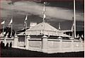
Malé, Medhu Ziyaaraiy, 1958
-
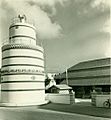
Malé, Bodu Buruzu, 1960
-
Malé Friday Mosque
-
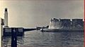
Malé beachfront, 1984
-
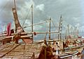
Malé beachfront, 1984


See also
 In Spanish: Malé para niños
