Malvern, Iowa facts for kids
Quick facts for kids
Malvern, Iowa
|
|
|---|---|
 |
|

Location of Malvern, Iowa
|
|
| Country | |
| State | |
| County | Mills |
| Area | |
| • Total | 1.59 sq mi (4.13 km2) |
| • Land | 1.59 sq mi (4.13 km2) |
| • Water | 0.00 sq mi (0.00 km2) |
| Elevation | 1,007 ft (307 m) |
| Population
(2020)
|
|
| • Total | 1,046 |
| • Density | 656.21/sq mi (253.39/km2) |
| Time zone | UTC-6 (Central (CST)) |
| • Summer (DST) | UTC-5 (CDT) |
| ZIP code |
51551
|
| Area code(s) | 712 |
| FIPS code | 19-48720 |
| GNIS feature ID | 0458747 |
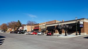
Malvern is a city located in Mills County, Iowa, United States. In 2020, about 1,046 people lived there. A cool bike trail called the Wabash Trace, which used to be a railroad, goes right through Malvern. The city also hosts the fun Mills County Fair every year. Even though Glenwood is the main county town, Malvern is the biggest town in the eastern part of Mills County.
Contents
History of Malvern
The town of Malvern began in the fall of 1869. It was first called Milton. However, people soon found out there was already another Milton in Iowa. So, the name was changed to Malvern.
Malvern was one of four towns that started when the Burlington and Missouri River Railroad was finished. This happened on November 18, 1869. The first people to live in Malvern were John D. Paddock and his wife. They arrived in September 1869. They built a small house that also served as the town's first store.
The new railroad quickly brought many new people and businesses to Malvern. A town called White Cloud, which had about 200 people, was located nearby. It closed down when the new railroad was built a few miles north. Many businesses and people from White Cloud then moved to Malvern.
Malvern grew very fast in its first two years. By its fifth year, the town had about 800 people. It was in a great area for farming. Soon, Malvern had many factories. These included a hog packing plant and a plant that made electricity in 1892. This electric plant also helped create a city water system.
In the early 1900s, Malvern became known for its poultry (chicken and turkey) industry. At one point, this industry employed up to 200 people. Malvern started its school system in 1870. The first county fair was held in 1873. A Chautauqua, which was a type of educational gathering, began in 1905. The town library was built in 1916, and the Liberty Memorial Community Building was built in 1926.
Later, when new highways were built in Iowa, Highway 34 did not pass through Malvern. This caused some economic challenges for the town. The local railroads, the Wabash and Tabor & Northern, also faced difficulties. In the 1950s, much of Iowa's poultry industry moved to Arkansas, which further affected Malvern.
Malvern's success has always been closely tied to farming. When there were fewer family farms and farm workers in the 1960s, 1970s, and especially the 1980s, Malvern's economy suffered. Many long-standing businesses in the community closed down.
Today, Malvern is a rural community. It has a golf course, a swimming pool, and a new library. There is also the Carnegie Conference Center. The town has agricultural businesses, government offices, a bank, and doctor's offices. The Mills County Fair Grounds are located here. The Wabash Trace Nature Trail is a popular spot for outdoor activities.
Geography
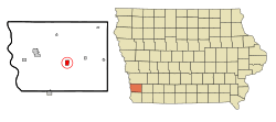
Malvern is located at 41°0′17″N 95°35′4″W / 41.00472°N 95.58444°W. The city covers a total area of about 1.59 square miles (4.13 square kilometers). All of this area is land.
Population and People
| Historical populations | ||
|---|---|---|
| Year | Pop. | ±% |
| 1880 | 748 | — |
| 1890 | 1,003 | +34.1% |
| 1900 | 1,166 | +16.3% |
| 1910 | 1,154 | −1.0% |
| 1920 | 1,195 | +3.6% |
| 1930 | 1,320 | +10.5% |
| 1940 | 1,325 | +0.4% |
| 1950 | 1,263 | −4.7% |
| 1960 | 1,193 | −5.5% |
| 1970 | 1,158 | −2.9% |
| 1980 | 1,244 | +7.4% |
| 1990 | 1,210 | −2.7% |
| 2000 | 1,256 | +3.8% |
| 2010 | 1,142 | −9.1% |
| 2020 | 1,046 | −8.4% |
| Source: and Iowa Data Center Source: |
||
2020 Census Information
In 2020, the city of Malvern had 1,046 people living in 423 households. About 275 of these households were families. The population density was about 656 people per square mile (253 per square kilometer). There were 474 housing units in the city.
Most of the people in Malvern were White (94.6%). A small number were from other racial backgrounds. About 2.2% of the population identified as Hispanic or Latino.
In terms of households, 30% had children under 18 living with them. About 46% were married couples living together. The median age in Malvern was 39.3 years. About 26.3% of residents were under 20 years old. The city's population was 48.2% male and 51.8% female.
2010 Census Information
In 2010, Malvern had 1,142 people living in 436 households. About 301 of these were families. The population density was about 960 people per square mile. There were 499 housing units.
Most of the people in Malvern were White (97.7%). A small number were from other racial backgrounds. About 0.8% of the population identified as Hispanic or Latino.
About 34.2% of households had children under 18. Half of the households (50%) were married couples. The median age in Malvern was 40.3 years. About 25.8% of residents were under 18 years old. The city's population was 47.4% male and 52.6% female.
Education
Students in Malvern attend schools within the East Mills Community School District. Before July 1, 2011, Malvern had its own school district called the Malvern Community School District. This district then merged to form the East Mills district. The Malvern and East Mills districts used to operate Chantry Elementary School in Malvern. However, this school closed in 2014.
See also
 In Spanish: Malvern (Iowa) para niños
 | Georgia Louise Harris Brown |
 | Julian Abele |
 | Norma Merrick Sklarek |
 | William Sidney Pittman |

