Maplehurst, Wisconsin facts for kids
Quick facts for kids
Maplehurst, Wisconsin
|
|
|---|---|

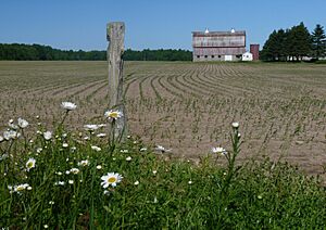
One-time dairy farm in a flat part of Maplehurst
|
|

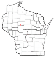
Location of Maplehurst, Wisconsin
|
|
| Country | |
| State | |
| County | Taylor |
| Area | |
| • Total | 35.9 sq mi (93.1 km2) |
| • Land | 35.9 sq mi (93.0 km2) |
| • Water | 0.0 sq mi (0.1 km2) |
| Elevation | 1,280 ft (390 m) |
| Population
(2000)
|
|
| • Total | 359 |
| • Density | 10.0/sq mi (3.9/km2) |
| Time zone | UTC-6 (Central (CST)) |
| • Summer (DST) | UTC-5 (CDT) |
| Area code(s) | 715 & 534 |
| FIPS code | 55-48925 |
| GNIS feature ID | 1583645 |
| PLSS township | T30N R2W |
Maplehurst is a town in Taylor County, Wisconsin, United States. In the year 2000, the population was 359 people. It is a small community with an interesting past, shaped by glaciers and early settlers.
Contents
Geography of Maplehurst
Maplehurst covers about 35.9 square miles (93.1 square kilometers). Most of this area is land, with only a tiny bit being water.
Landforms Shaped by Glaciers
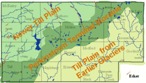
The northwest part of Maplehurst has hilly land. This area is a terminal moraine, which means it was formed by rocks and dirt left behind by a giant glacier (a huge sheet of ice). This happened about 15,000 years ago during the Wisconsin glaciation, the last ice age. Because it's a newer landform, it's still quite bumpy.
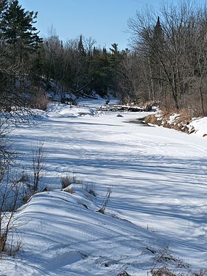
Inside this hilly area, you can find some flat spots called ice-walled lake plains. These areas are good for farming. Outside the northwest corner, most of Maplehurst is pretty flat. This flatter land is covered with till, which is also dirt and rocks left by an older glacier. This older till has had much more time to become smooth and level. The Black River and other smaller streams flow through these flat areas, carving out channels.
History of Maplehurst
The area that is now Maplehurst was first mapped out in the summer of 1847. This was done by a team working for the U.S. government. They marked the boundaries of the land.
Early Surveys and Descriptions
In May 1854, another team came to mark all the section corners in the area. They walked on foot, using a chain to measure distances and a compass to find directions. After they finished, the surveyor wrote a description of the land.
He said the area had many swamps, some of them quite large. The land was generally uneven, and the soil was not very good for growing things. He noted that the ground was covered with thick moss. The main trees were Hemlock, with a few White Pine trees that were not very strong. The area had many small streams and the Black River, which flowed through it. The riverbanks were high, and the water flowed gently over a rocky bottom. At that time, there were no settlers living in the township.
Logging and Railroads
An 1880 map of the area showed very little development. There was only one logging camp, belonging to "A.E. Sawyer," located near the Black River. This camp was used by Sawyer's company from Black River Falls.
Around 1900, a map showed that the Wisconsin Central Railroad owned a lot of land in what would become Maplehurst. The U.S. government had given the railroad half the land on both sides of their tracks to help them pay for building the railway. Maplehurst was within this area. By 1900, the railroad had sold some land to lumber companies, but they still owned large parts of it.
Other big landowners included Sawyer and Austin, J.M. Holway, and the N. Wisconsin Land Co. The map also showed a sawmill on the Black River. There was a road following part of the northern edge of the township, which is now Highway 64. Another road followed what is now County A into the eastern part of the town. Settlers, many with Scandinavian names, started to appear along the Black River.
Growth and Community Development
By 1911, a new map of Maplehurst showed more roads and more settlers. A community called Maplehurst was planned where modern County T and Shiner Avenue meet. A map from 1913 showed neatly planned streets, a hotel, a store, and a school in this community. Some people believe a railroad track connected Maplehurst to the Soo Line railroad to the south.
Around this community, the map showed a good network of roads. Another road had reached up to what is now Putnam Drive, and a school was marked near a group of settlers there. Another school and a sawmill were also marked on the road that would become modern County A. The southern half of the town was becoming quite populated with settlers. However, most of the northern half was still empty, owned by the Wisconsin Central, land companies, and lumber companies. The Soo Line railroad crossed the very southwest corner, heading towards Lublin. The Owen Lumber Company's logging track crossed the northwest corner near Diamond Lake. During this time, the area was changing from a place focused on logging to one focused on farming.
People of Maplehurst (Demographics)
In the year 2000, the census counted 359 people living in Maplehurst. There were 133 households, and 98 of these were families. This means there were about 10 people for every square mile.
Households and Families
- Out of 133 households, about 34.6% had children under 18 living there.
- Most households (59.4%) were married couples living together.
- About 9.0% had a female head of household without a husband present.
- About 21.1% of all households were made up of single individuals.
- About 9.8% of households had someone living alone who was 65 years old or older.
- The average household had 2.70 people, and the average family had 3.14 people.
Age Distribution
The population in Maplehurst was spread out across different age groups:
- 28.4% were under 18 years old.
- 8.4% were between 18 and 24 years old.
- 27.3% were between 25 and 44 years old.
- 25.3% were between 45 and 64 years old.
- 10.6% were 65 years old or older.
The average age in Maplehurst was 35 years. For every 100 females, there were about 119 males.
Income and Economy
In 2000, the average income for a household in Maplehurst was $29,375 per year. For families, the average income was $32,813 per year. On average, males earned more than females. The average income per person in the town was $13,062.
About 11.7% of families and 19.2% of all people in Maplehurst lived below the poverty line. This included 26.4% of those under 18 and 8.5% of those 65 or older.
See also
 In Spanish: Maplehurst (Wisconsin) para niños


