Marble Canyon Dam facts for kids
Quick facts for kids Marble Canyon Dam |
|
|---|---|
|
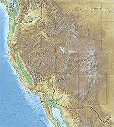
Location of the proposed Marble Canyon Dam in the western United States, lower site
|
|
| Country | United States |
| Location | Coconino County, Arizona |
| Coordinates | 36°25′2.5″N 111°52′06.75″W / 36.417361°N 111.8685417°W |
| Status | Proposed |
| Construction cost | $238 million (est.) |
| Owner(s) | U.S. Bureau of Reclamation |
| Dam and spillways | |
| Impounds | Colorado River |
| Height | 310 ft (94 m) |
| Reservoir | |
| Creates | Marble Canyon Reservoir |
| Total capacity | 363,000 acre⋅ft (0.448 km3) |
| Normal elevation | 3,140 ft (960 m) |
| Power station | |
| Installed capacity | 600 MW |
| Annual generation | 2.31 billion KWh |
The Marble Canyon Dam, also called the Redwall Dam, was a dam planned for the Colorado River in Arizona. Its main goal was to create a lake (reservoir) in the middle of Marble Canyon. This lake would then help make electricity using water power.
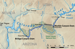
Engineers looked at two possible spots for the dam in the canyon. At one point, there was even a plan for a 38-mile (61 km) long tunnel. This tunnel would have sent most of the Colorado River's water around Grand Canyon National Park. This would have left only a tiny stream flowing through the park.
The idea for the dam first came up in the 1920s. But serious work didn't start until the 1940s. It became part of a big plan by the U.S. government agency called the U.S. Bureau of Reclamation. The dam was meant to work with another planned dam, the Bridge Canyon Dam. Together, they would make the electricity needed to pump water from Lake Havasu to farms and cities in central Arizona. This included big cities like Phoenix and Tucson. The dams were also supposed to earn money by selling cheap electricity. This money would then pay for other water projects in the future.
After many studies, the dam project was eventually stopped. This happened so that another important water project, the Central Arizona Project, could move forward. In 1968, the areas where the dams would have been built became part of Marble Canyon National Monument. This monument was later added to Grand Canyon National Park in 1975.
Contents
Why Build the Marble Canyon Dam?
The U.S. Bureau of Reclamation first suggested building a dam in Marble Canyon in the 1940s. This location was very remote and hard to reach. It was about 2,500 feet (760 m) below the canyon's rim.
The proposed dam would have been about 310 feet (94 m) high. It would have used a special thin, curved concrete design. The lake it created would hold about 363,000 acre-feet of water. To keep the lake from filling up with mud and dirt (silt), smaller dams were needed on nearby creeks. For example, a dam in Paria Canyon was planned to be 380 feet (120 m) tall. Even with these extra dams, the Marble Canyon lake was expected to last only about 104 years before filling with silt.
Making Electricity and Saving the Grand Canyon
One exciting part of the Marble Canyon dam idea was its potential to make a lot of electricity. It also aimed to do this without building a dam or lake inside Grand Canyon National Park. The plan was to send about 90% of the Colorado River's water into a 38-mile (61 km) long tunnel. This tunnel would be 36 feet (11 m) wide and carry a huge amount of water.
The water would travel to a power plant outside the national park. This plant would use the water's drop in height (about 1,300 feet (400 m)) to make electricity. It could produce about 6.5 billion kilowatt hours each year. This is almost twice as much as the famous Hoover Dam produces! This tunnel system would let the dam bypass the Grand Canyon National Park. It would avoid building more dams between Marble Canyon and Bridge Canyon.
A small amount of water, about 1,000 cubic feet per second (28 m3/s), would always be released from Marble Canyon. This "scenic trickle" was meant for wildlife and recreation in the Grand Canyon. This water would also go through a smaller power station at the dam's base. By the 1960s, the idea of the long tunnel was dropped. Instead, a 600 MW power station was planned right at the dam's base. This made the project much cheaper.
Powering Arizona's Future
The Marble Canyon Dam and the Bridge Canyon Dam were meant to be "cash register" power plants. This means that selling the electricity they made would pay for their construction. It would also provide money for future water projects. The electricity would be very important for pumping water for the Central Arizona Project (CAP). This project would lift water from the Colorado River near Lake Havasu to central and southern Arizona. The pumped water would reach as far as Tucson, which is about 2,000 feet (610 m) higher than the Colorado River.
The Bureau of Reclamation had even bigger plans. They hoped the money from these dams would help fund projects to bring water from the Columbia River system to the Colorado River. The Colorado River often doesn't have enough water because too much is taken from it. So, the power from these dams was seen as a way to fund other important water projects, not just as a goal itself.
Exploring the Dam Site
The idea of building a dam in Marble Canyon was first looked at in the 1920s. The United States Geological Survey identified many possible dam sites along the Colorado River. Even though the Bureau of Reclamation was interested in Marble Canyon, these plans were put on hold. They decided to build the Hoover Dam first. Hoover Dam could store much more water for farming and flood control.
After Hoover Dam was finished, the Bureau turned its attention back to the Grand Canyon. This area had the most potential for making electricity from water in the American Southwest. In the late 1940s, teams led by engineer Bert Lucas started surveying Marble Canyon. They found at least two good spots for a dam. One was 32.8 miles (52.8 km) below Lee's Ferry, and the other was at 39.4 miles (63.4 km). A 25-mile (40 km) road had to be built to connect the nearest highway to the dam site. It was one of the hardest places to reach that the Bureau had ever explored.
In 1949, the Bureau asked companies to bid on building a 3,400-foot (1,000 m) cableway. This cableway would carry workers and materials down into the remote canyon. Once it was built, a temporary camp was set up at the bottom of the gorge. Exploratory drilling began in 1951. At the lower site, they dug two tunnels and drilled 32 holes in the riverbed. At the upper site, they drilled 35 holes and dug two tunnels. Workers reached these sites using an aerial tram from the canyon rim.
The lower site was preferred because it offered a greater drop in water height. This meant it could make more electricity and create a larger lake. However, it needed more work to fix weak rock areas. The Bureau of Reclamation did not continue with the project in the 1950s.
In 1960, the Arizona Power Authority became interested in the site. The lake would have been entirely in Arizona, giving the state control over the water and power. In 1963, the Bureau of Reclamation director, Floyd Dominy, supported the idea. Studies for the project continued into 1964. However, in 1965, a Bureau report found that holes in the limestone upstream would prevent the lake from holding water. By 1968, the Marble Canyon project was dropped. This was part of a deal between Arizona and California lawmakers. Arizona supported the Central Arizona Project, while California opposed it and the dam.
Why the Dam Was Never Built
In 1969, President Lyndon B. Johnson announced the creation of Marble Canyon National Monument. This decision effectively stopped any chance of building a dam in Marble Canyon. In 1975, the monument was added to Grand Canyon National Park through the Grand Canyon Enlargement Act.
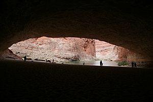
If the lower dam had been built, it would have flooded several natural wonders. These include Redwall Cavern and Vasey's Paradise. The upper dam site was just above Redwall Cavern, which is why it was sometimes called the Redwall Dam.
 | Percy Lavon Julian |
 | Katherine Johnson |
 | George Washington Carver |
 | Annie Easley |


