
Bridge Canyon Dam facts for kids
Quick facts for kids Bridge Canyon Dam |
|
|---|---|

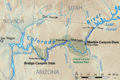
Map showing the Bridge and Marble Canyon Dam projects
|
|

Location of the proposed Bridge Canyon Dam in the western United States
|
|
| Country | United States |
| Location | Mohave County, Arizona |
| Coordinates | 35°48′53″N 113°34′01″W / 35.81472°N 113.56694°W |
| Status | Proposed |
| Construction cost | $500 million (est.) |
| Owner(s) | U.S. Bureau of Reclamation |
| Dam and spillways | |
| Impounds | Colorado River |
| Height | 740 ft (230 m) |
| Length | 1,700 ft (520 m) |
| Reservoir | |
| Creates | Bridge Canyon Reservoir |
| Total capacity | 3,710,000 acre⋅ft (4.58 km3) |
| Catchment area | 140,000 sq mi (360,000 km2) |
| Surface area | 24,000 acres (9,700 ha) |
| Normal elevation | 1,866 ft (569 m) |
| Power station | |
| Hydraulic head | 672 ft (205 m) |
| Installed capacity | 1,500 MW |
| Annual generation | 5.36 billion KWh |
The Bridge Canyon Dam, also known as Hualapai Dam, was a large dam that was planned for the Colorado River in the Grand Canyon in Arizona, United States. It would have been built near Bridge Canyon Rapids. This area is very wild and hard to reach. The dam site was about 235 miles (378 km) downstream from Lees Ferry. It was also at the very top end of Lake Mead.
People first thought about building this dam in the 1920s. The U.S. Bureau of Reclamation seriously looked into the idea for over 20 years, from the early 1950s until 1968. If the dam had been built, it would have been 740 feet (230 m) tall. It would have created a huge lake stretching over 90 miles (140 km) upstream. This lake would have included 13 miles (21 km) along the edge of Grand Canyon National Park.
The main goal of the dam was to create hydroelectric power. This means making electricity from the force of moving water. It would have worked with other dams upstream, like the Marble Canyon Dam. However, the project faced strong public opposition. People worried about the huge damage it could cause to the environment. Also, the flow of the Colorado River was getting lower. Because of these reasons, the project stopped in 1968. Even so, this spot is still considered one of the best places in the western U.S. for a large dam.
Contents
Why Was Bridge Canyon Dam Proposed?
The idea for the Bridge Canyon Dam became serious in the mid-1900s. It was part of a bigger plan called the Pacific Southwest Water Plan. This plan aimed to bring water from the Colorado River to central Arizona. Arizona wanted to use its full share of water from the Colorado River Compact.
The plan included building a canal from Lake Havasu on the Colorado River. This canal would supply water to Phoenix and nearby farms. To pump water uphill along the canal, a lot of electricity was needed. Two dams in the Grand Canyon were proposed to make this power.
- One dam, called Marble Canyon Dam, would be at the lower end of Marble Canyon.
- The other, Bridge Canyon Dam, would be in Bridge Canyon.
Together, these two dams were expected to produce a lot of electricity. They could generate between 2,000 and 3,000 megawatts of power. This would be enough to power many homes and businesses.
Exploring the Dam Site
In the 1940s, the Bureau of Reclamation started looking for good places to build a dam. They explored sites in the lower Grand Canyon. These sites were near where the Colorado River meets Diamond Creek. This was about 25 to 40 miles (40 to 64 km) upstream from Lake Mead.
Workers set up a small camp by the Colorado River near Bridge Canyon. It had a kitchen, a refrigerator, and tents for sleeping. There was even a small generator for lights and fans. The area was very hot, and it was hard to get to. Workers had to travel 30 miles (48 km) by boat from Lake Mead. They also worked long hours.
After checking more than four possible dam locations, they found the best one. It was called the "Lower Gneiss" site. This spot was below where a small stream called Gneiss Canyon joins the river. It was also 19 miles (31 km) northwest of Peach Springs. The proposed dam would have been a concrete arch-gravity structure. It would stand 736 to 740 feet (224 to 226 m) high above its base. The water behind it would rise for 93 miles (150 km) upstream.
Why Was the Dam Project Stopped?
When the dam plans became public, environmental groups quickly opposed them. Groups like the Sierra Club spoke out against the project. Many people who enjoyed outdoor recreation also protested. The main concern was that the dam would flood parts of the Grand Canyon. The water would back up for 13 miles (21 km) along the border of Grand Canyon National Park. It would also flood 40 miles (64 km) through Grand Canyon National Monument.
People were already worried about dams affecting protected lands.
- The O'Shaughnessy Dam was built in Yosemite National Park in 1924.
- The Glen Canyon Dam was finished in 1966.
- There was also a big fight over the proposed Echo Park Dam. That dam would have flooded parts of Dinosaur National Monument in Utah. These past events made people even more determined to stop Bridge Canyon Dam.
Earlier Attempts to Build the Dam
The Bridge Canyon Dam project failed several times before. In 1938, Arizona tried to get permission from the government to build it. Again in 1950, a bill was introduced in Congress for the dam. This time, it wasn't environmental groups that stopped it. Instead, politicians from California in the United States House of Representatives blocked the plan. California did not want Arizona to use more of the Colorado River's water. They worried it would mean less water for their own state.
Impact on Natural Landmarks
Even though the dam site was in a remote part of the Colorado River, it would have destroyed many famous places. These include:
- The lower part of Havasu Creek, known for its beautiful rock formations and waterfalls.
- Lava Falls, one of the most exciting rapids on the Colorado River.
Opponents argued that the dam's benefits were not worth the damage. The dam would not hold much water compared to its size. Also, it could cause more than 85,000 acre-feet (105,000,000 m3) of water to evaporate each year. This loss of water and destruction of nature was seen as too high a price.
Sediment and the Dam's Lifespan
The Colorado River carries a lot of mud and sand, called sediment. Over time, this sediment would fill up the Bridge Canyon Reservoir. This would make the dam useless. The Sierra Club thought the dam would only last 60 to 160 years. The U.S. Bureau of Reclamation predicted it would last 163 years.
To make the dam last longer, the Bureau of Reclamation suggested building more dams. These "silt traps" would be on rivers like Kanab Creek, the Little Colorado River, and Paria River. They hoped this would extend the dam's life to 250 years.
However, the Glen Canyon Dam was completed in 1966. This dam is 251 miles (404 km) upstream from Bridge Canyon. It greatly reduced the amount of sediment flowing through the Grand Canyon. This meant the Bridge Canyon project could last much longer. But even this was not enough to save the dam. The Bridge Canyon project officially stopped in 1984.
The original Pacific Southwest Water Plan was eventually put into action on a smaller scale. It is now known as the Central Arizona Project. To make up for the power that Bridge and Marble Canyon Dams would have provided, a coal-fired power plant was built. This plant, the Navajo Generating Station, was completed near Page, Arizona in 1976.
Images for kids
-
Map showing the Bridge and Marble Canyon Dam projects
