
Havasu Creek facts for kids
Quick facts for kids Havasu Creek |
|
|---|---|

Travertine formations
|
|

Location of the mouth of Havasu Creek in Arizona
|
|
| Country | United States |
| State | Arizona |
| County | Coconino |
| Physical characteristics | |
| Main source | Havasupai Indian Reservation Havasu Springs 3,260 ft (990 m) 36°13′00″N 112°41′13″W / 36.21667°N 112.68694°W |
| River mouth | Colorado River Havasu Rapids, Grand Canyon 2,093 ft (638 m) 36°18′28″N 112°45′43″W / 36.30778°N 112.76194°W |
Havasu Creek is a beautiful stream in Arizona, a state in the United States. It is very special to the Havasupai people, who live nearby. This creek flows into the mighty Colorado River right inside the famous Grand Canyon.
Contents
The Amazing Havasu Creek
Havasu Creek is one of the biggest streams that flows into the Colorado River within Grand Canyon National Park. The area where all its water collects, called its drainage basin, is huge! It covers about 3,000 square miles (7,800 km2), including towns like Williams, Arizona.
The creek begins as tiny trickles of snowmelt and rainwater far above the canyon. This water winds its way for about 50 miles (80 km) across the plains. Then, it enters a deep gorge called Cataract Canyon, also known as Havasu Canyon. At Havasu Springs, underground water joins the creek, making it much bigger. You can find this spring by walking upstream when you first reach the creek.
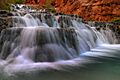
The water in Havasu Creek is famous for its bright blue-green color. This special color comes from a mineral called calcium carbonate in the water. This mineral also creates unique rock formations called travertine. These formations line the creek and reflect the water's color. Because of these minerals, the creek is always changing! Anything that falls into the water quickly turns into new rock formations. This means the creek never looks exactly the same from one year to the next. The creek flows right through the village of Supai before it finally joins the Colorado River.
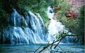
Waterfalls of Havasu Creek
Havasu Creek is home to several stunning waterfalls. These falls are known for their beautiful blue-green pools and unique rock formations.

Before a big flood in August 2008, Navajo Falls was the first main waterfall you would see in the canyon. It was named after an old chief of the Supai tribe. The falls were about 70 feet (21 m) tall. Water cascaded down in several chutes, creating a popular swimming spot.
However, the flood in August 2008 completely changed Navajo Falls. The powerful water moved so much mud and rock that it created a new path for Havasu Creek. This new path went around the old Navajo Falls site. So, while the spot still exists, the waterfall itself was rerouted by nature's power.
Fiftyfoot Falls

This waterfall is also called Upper Navajo Falls. It became much more noticeable after the 2008 flood, which changed the path of Navajo Falls. Now, Fiftyfoot Falls is the first waterfall you see in the canyon. It is about 50 feet (15 m) tall and drops into a rocky pool.
Fiftyfoot Falls has changed many times over the years. It used to be called Supai Falls and has appeared and disappeared several times since 1885. Its most recent return was in 1970.

This waterfall is also known as Rock Falls. It was actually created by the powerful 2008 flood! It's located about .15 miles (0.24 km) below Fiftyfoot Falls. The creek here drops about 30 feet (9.1 m) into a nice swimming hole.
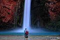
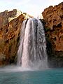
Havasu Falls

Havasu Falls is the third main waterfall in the canyon. It's located about 1 ½ miles from Supai village. This is probably the most famous and most visited of all the falls. Havasu Falls has one main stream of water that plunges over a 100-foot (30 m) tall cliff. Because of the many minerals in the water, the falls are always changing. Sometimes, they even split into two separate streams!
The falls are famous for their natural pools, which are formed by the minerals in the water. Sadly, many of these pools were damaged or destroyed by big floods in the early 1990s. A small human-made dam was built to help bring back some of the pools. There are picnic tables nearby, and it's easy to cross the creek by walking along the edges of the pools. If you're a good swimmer, you can even swim behind the falls into a small cave!
Before a flood in 1910, these falls were called "Bridal Veil Falls." This was because the water used to fall across the entire width of the cliffs, like a wide veil.
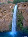
Mooney Falls

Mooney Falls is the fourth main waterfall in the canyon. It's named after a miner named D. W. "James" Mooney. In 1882, he was exploring the area for minerals. According to stories, he tried to climb up the falls with an injured friend tied to his back and sadly fell to his death.
The falls are located about 2.25 miles (3.6 km) from Supai, just past the campgrounds. You can reach the top of the falls, where there's a great spot to take photos and look out over the 210-foot (64 m) canyon wall. Getting to the bottom of Mooney Falls and its pool is a very challenging climb. You need to be extremely careful and only try it when the weather is good.
The path down is next to the canyon wall. The first part is moderately tricky. Then, you enter a small cave-like passage. After this, the path becomes very difficult, like climbing down a ladder. There are chains, handholds, and ladders to help you. The mist from the falls can make the rocks slippery, so watch your step!
The pool at the bottom of Mooney Falls is the largest of all the falls. Some people like to jump from low cliff ledges into the water. Strong swimmers can swim to a small cave located near the falls.
Beaver Falls

Beaver Falls is often considered the fifth set of falls, though some people see it as a series of smaller falls close together. It's located about 6 miles (9.7 km) downstream from Supai and is the most difficult waterfall to reach. After you climb down to Mooney Falls, a trail continues downstream.
The trail to Beaver Falls is rugged and not always easy to follow. You'll need to cross the creek many times. There's even a spot where you might need to use a ladder to climb down a rock wall. Further downstream, you can find ways to reach the falls. The pools here are smaller but still great for swimming.
Beaver Falls used to be much bigger and more impressive. It was once about fifty feet tall in one single drop! However, a huge flood in January 1910 destroyed it, leaving the falls as they are today, flowing over several limestone ledges.
Other Waterfalls
Because of frequent floods, the waterfalls along Havasu Creek are always changing. Some waterfalls might appear or disappear, and others might change their shape. Navajo Falls, mentioned above, is a good example of how floods can change the landscape.
Where the Creek Meets the River
After Beaver Falls, Havasu Creek continues its journey to the Colorado River. The hike to where the creek meets the river, called the confluence, is about 3 miles (4.8 km) long. It is a very difficult and rugged hike, so it's best for experienced hikers. At the confluence, there are some camping spots. This area is also a popular stop for people who are rafting down the Colorado River.
Flooding in Havasu Creek
Flooding happens often along Havasu Creek. Government records show at least 14 major floods between 1899 and 1993. One big flood happened on August 17, 2008. Heavy rains caused the Redlands Dam on Havasu Creek to break. The floodwaters were so strong that local officials had to help people leave the village. About 400 people were flown to safety by rescue crews. This flood also changed the waterfalls: Navajo Falls was bypassed, Fiftyfoot Falls became more noticeable, and Lower Navajo Falls was created.
Images for kids
-
Mooney Falls in the morning
-
Navajo Falls before the flood
-
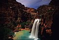
Havasu Falls at night, before 2008 flash flood
-
Mooney Falls
-
Beaver Falls
-
Havasu Falls prior to 2008 flash flood
-
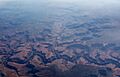
An aerial view of Havasu Creek flowing into the Colorado River


