
Supai, Arizona facts for kids
Quick facts for kids
Supai, Arizona
|
|
|---|---|

Church building in Supai
|
|

Location in Coconino County and the state of Arizona
|
|

Supai, Arizona
Location in Arizona

Supai, Arizona
Location in the United States
|
|
| Country | |
| State | |
| County | Coconino |
| Area | |
| • Total | 1.72 sq mi (4.46 km2) |
| • Land | 1.72 sq mi (4.46 km2) |
| • Water | 0.00 sq mi (0.00 km2) |
| Elevation | 3,202 ft (976 m) |
| Population
(2010)
|
|
| • Total | 208 |
| • Density | 120.9302/sq mi (46.6367/km2) |
| Time zone | UTC-7 (MST) |
| ZIP code |
86435
|
| Area code | 928 |
| FIPS code | 04-71230 |
| GNIS feature ID | 2410036 |
Supai (called Havasuuw by the Havasupai people) is a small community in Arizona, United States. It is located deep inside the Grand Canyon. In 2010, about 208 people lived there. Supai is the main village of the Havasupai Indian Reservation.
It is the only place in the United States where mail is still carried by mules. The U.S. Department of Agriculture has called Supai "the most remote community" in the mainland United States. You can only reach it by helicopter, walking, or riding a mule. Supai is 8 miles (13 km) from the nearest road. There are no cars in the community.
Contents
History of Supai Village
Supai has faced challenges over the years. In 1910, a big flood affected the town.
In the 1960s, a tourist named Martin Goodfriend started to speak up for the Supai people. A newspaper writer, Don Dedera, wrote articles about Goodfriend's discoveries.
Flooding Events and Evacuations
Supai has experienced several floods. In August 2008, heavy rain caused Havasu Creek to flood. A dam also broke, making things worse. Tourists and some residents had to be evacuated by helicopter. They were taken to Peach Springs, Arizona. The floods were so serious that news channels around the world reported on them.
The floods badly damaged trails, bridges, and campgrounds. Because of this, visitors could not enter the village or falls until spring 2009. More floods in 2010 caused more damage and kept the area closed until May 2011. In July 2018, another flash flood forced 200 visitors to be evacuated by helicopter.
Tourism Suspension during COVID-19
From March 2020 until February 2023, all tourism to Supai was stopped. This was due to the COVID-19 pandemic.
Geography and Climate of Supai

Supai is located inside the Grand Canyon. You can only get there by walking, riding a pack animal, or taking a helicopter. Because of this, mail and packages take longer to arrive. Mail from Bullhead City, Arizona, for example, takes at least a week because mules carry it.
The community covers about 1.7 square miles (4.4 square kilometers) of land. It sits about 3,195 feet (974 meters) above sea level.
Supai Climate Information
| Climate data for Supai, 1956–1987 | |||||||||||||
|---|---|---|---|---|---|---|---|---|---|---|---|---|---|
| Month | Jan | Feb | Mar | Apr | May | Jun | Jul | Aug | Sep | Oct | Nov | Dec | Year |
| Record high °F (°C) | 79 (26) |
87 (31) |
95 (35) |
98 (37) |
104 (40) |
112 (44) |
116 (47) |
111 (44) |
111 (44) |
102 (39) |
86 (30) |
85 (29) |
116 (47) |
| Mean daily maximum °F (°C) | 52.8 (11.6) |
59.8 (15.4) |
67.7 (19.8) |
76.1 (24.5) |
85.1 (29.5) |
95.7 (35.4) |
99.0 (37.2) |
95.6 (35.3) |
90.1 (32.3) |
77.0 (25.0) |
62.8 (17.1) |
52.8 (11.6) |
76.1 (24.5) |
| Mean daily minimum °F (°C) | 29.4 (−1.4) |
34.5 (1.4) |
39.2 (4.0) |
45.5 (7.5) |
53.2 (11.8) |
61.7 (16.5) |
67.1 (19.5) |
65.4 (18.6) |
58.4 (14.7) |
47.8 (8.8) |
37.4 (3.0) |
30.0 (−1.1) |
47.5 (8.6) |
| Record low °F (°C) | −1 (−18) |
5 (−15) |
13 (−11) |
23 (−5) |
29 (−2) |
36 (2) |
46 (8) |
42 (6) |
34 (1) |
19 (−7) |
0 (−18) |
−4 (−20) |
−4 (−20) |
| Average precipitation inches (mm) | 0.61 (15) |
0.63 (16) |
0.88 (22) |
0.38 (9.7) |
0.41 (10) |
0.26 (6.6) |
1.24 (31) |
1.42 (36) |
0.65 (17) |
0.61 (15) |
0.72 (18) |
0.75 (19) |
8.54 (217) |
| Average snowfall inches (cm) | 0.4 (1.0) |
0.2 (0.51) |
0 (0) |
0 (0) |
0 (0) |
0 (0) |
0 (0) |
0 (0) |
0 (0) |
0 (0) |
0.1 (0.25) |
0.6 (1.5) |
1.2 (3.0) |
| Average precipitation days (≥ 0.01 in) | 4 | 4 | 5 | 3 | 2 | 1 | 5 | 6 | 3 | 3 | 3 | 4 | 44 |
| Source: WRCC | |||||||||||||
Supai Population and Demographics
A census counts how many people live in an area. Sometimes, it's hard to get an exact count for communities on reservations. The 2020 census incorrectly reported Supai's population as zero. However, in 2023, the Associated Press reported that about 500 of the nearly 770 Havasupai tribe members live in the village.
| Historical population | |||
|---|---|---|---|
| Census | Pop. | %± | |
| 1990 | 423 | — | |
| 2000 | 503 | 18.9% | |
| 2010 | 208 | −58.6% | |
| 2020 | 0 | −100.0% | |
U.S. Decennial Census
|
|||
In the 2010 census, there were 208 people living in Supai. Most residents (96.6%) were Native American.
There were 43 households. About 34.9% were married families living together. The average household had about 4.84 people. The population was quite young, with 30.8% of residents under 16 years old. The average age was 25.2 years.
Education in Supai

Supai has one school for younger students, Havasupai Elementary School. It teaches students from kindergarten to 8th grade. The Bureau of Indian Education runs this school. There was also a Head Start program in Supai by 1970 for very young children.
Supai does not have a high school. In 1988, students who finished 8th grade often went to boarding schools. A common one was Sherman Indian High School in Riverside, California. In the 1960s, older students sometimes went to schools in Fort Apache or Phoenix. Some students also stayed with host families to attend public schools.
Accessing Supai Village

To reach Supai, you can hike 8 miles (13 km) down into the canyon from Hualapai Hilltop. This trail drops about 2,004 feet (611 meters) in elevation. Helicopters also fly from Hualapai Hilltop to Supai. Hualapai Hilltop is the start of the Havasupai Trail. It is about 70 miles (110 km) from Peach Springs, Arizona, along a paved road called BIA Road 18.
Culture and Music in Supai
Reggae music is very popular in the Supai community. People there feel a connection to the Rastafarian faith. In 1982, music producer Chris Blackwell learned about this. He flew into Supai with a grand piano and held a concert.
In 1984, an Arizona reggae band called Shagnatty also performed there. A photojournalist with the band reported that residents said reggae had been popular for 25 years. Visitors from California had first introduced the music. Community members even joined the band on stage to sing along.
Tourism in Supai
Tourism is very important for Supai's economy. When COVID-19 stopped tourism, the tribe estimated a 60-day closure would mean a 15% loss of their yearly income.
Around 20,000 people visit Supai each year. Most come to see and hike around Havasu Falls and other nearby waterfalls. There is a campground and the Havasupai Lodge in Supai. These are on tribal land. There is also a National Park Service campground and Phantom Ranch outside Supai, on national park land.
Services Available in Supai
Supai has a small, air-conditioned place to stay called Havasupai Lodge. There is also a convenience store and a cafe for visitors and residents.
Images for kids
-
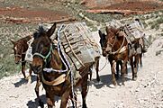
Mule train from Supai carrying U.S. Postal Service boxes
-
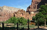
Water tanks above the village, supplying water pressure for plumbing
-
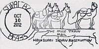
Supai AZ postmark, unique for its "mule train" design
-
Helicopter and helipad


See also
 In Spanish: Supai (Arizona) para niños
