Havasupai Indian Reservation facts for kids
Quick facts for kids
Havasupai Indian Reservation
Havsuw’ Baaja
|
||
|---|---|---|
|
||

Location of Havasupai Indian Reservation
|
||
| Capital | Supai | |
| Government | ||
| • Body | Havasupai Tribal Council | |
| Area | ||
| • Total | 763.22 km2 (294.68 sq mi) | |
| Population
(2010)
|
||
| • Total | 639 | |
| • Density | 0.8372/km2 (2.1685/sq mi) | |
| Time zone | MST | |
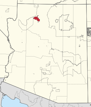
The Havasupai Indian Reservation is a special place for the Havasupai people. They are a Native American tribe. This reservation is completely surrounded by the famous Grand Canyon National Park in Coconino County, Arizona. It is known as one of America's most distant Indian reservations.
The Havasupai people govern their reservation with a seven-member tribal council. A chairman, chosen from the council members, leads this group. The main village on the reservation is Supai. It is located at the bottom of Cataract Canyon, which is a smaller canyon connected to the Grand Canyon. The name "Havasupai" means "people of the blue-green waters." This comes from the words Havasu (blue-green water) and pai (people).
Contents
History of the Havasupai People
For many centuries, the Havasupai people lived, farmed, and hunted in their traditional lands. These lands included the canyons and plateaus around Havasu Canyon. They grew crops in the canyons during spring and summer. In the fall and winter, they moved to the plateau areas.
In the 1870s, more European miners, ranchers, and settlers came to the Arizona Territory. This led to pressure to limit the Havasupai and other tribes to smaller areas. In 1882, President Chester Arthur created the Havasupai Indian Reservation. He restricted the tribe to only 518 acres in Havasu Canyon. The U.S. government took the rest of their ancestral lands for public use. The Havasupai people did not even know about this order for several years. Losing their land greatly changed their way of life. It also caused ongoing problems between the tribe and the U.S. government.
When the Grand Canyon National Park was created in 1919, the reservation became fully surrounded by park lands. The Havasupai tribe kept control over their reservation and the trails leading to it. The tribe kept asking the United States to return more of their ancestral land. However, their requests were not successful for a long time. In the 1950s, a Grand Canyon leader suggested taking over the reservation. But the tribe strongly refused this idea.
The tribe's determination eventually paid off. In 1968, they won a case against the government. The court ruled that their lands were taken illegally in 1882. The tribe had the right to get their lands back by paying for them. The price was set at about one million dollars. But the tribe still wanted their lands returned without having to pay.
The Nixon administration supported the tribe's efforts. The tribe then worked to pass a new law in Congress. Finally, in 1975, the U.S. Congress passed the Grand Canyon National Park Enlargement Act. President Gerald Ford signed it into law on January 4, 1975. This law returned 188,077 acres of plateau and canyon lands to the Havasupai. This is the land that makes up the reservation today.
The Havasupai tribe still speaks Yuman. This is one of about 200 native languages still spoken in North America.
How the Havasupai Government Works
The Havasupai tribe created their Constitution on March 27, 1939. This document set up their government. It is run by a seven-member tribal council. This council makes most of the important decisions. Four council members are elected and serve for two years. The other three council members are hereditary chiefs, who serve for life. A chairman, chosen from the council, leads the tribe.
The Bureau of Indian Affairs (BIA) helps with law enforcement and safety for the tribe. The Indian Health Service clinic provides healthcare and emergency services.
Geography and Unique Features
The Havasupai Reservation is in Coconino County. It sits in the southwest part of the Grand Canyon National Park. It is known as one of the most isolated reservations in America. The closest town is Peach Springs, Arizona, about 64 miles southwest.
The reservation's landscape includes plateaus cut by deep canyons. The plateau areas have gentle slopes and steep cliffs. Cataract Canyon, also called Havasu Canyon, is special. It has high amounts of a mineral called travertine in Havasu Creek. This mineral gives the streams and ponds their beautiful blue-green color. Cataract Canyon is the largest side-canyon connected to the Grand Canyon. There is also a small village called Indian Gardens.
The main village on the reservation is Supai. It is located in Cataract Canyon. The U.S. Department of Agriculture calls Supai "the most remote community" in the contiguous United States. You can only reach it by helicopter, on foot, or by mule. Supai is 8 miles from the nearest road and has no cars. It is the only place in the United States where mail is still carried by mules.
Important natural spots include The Great Thumb, Long Mesa, and Tenderfoot Mesa. The main attraction is Havasu Creek. Its water is aquamarine because of the travertine. This stream is one of the longest rivers flowing into the south side of the Colorado River. It drops 1,400 feet along its path. The stream is famous for its amazing waterfalls. These include Havasu Falls, Mooney Falls, and Beaver Falls. Navajo Falls, another well-known waterfall, disappeared after a big flood in 2008. But the flood created two new waterfalls: Fifty Foot Falls and Little Navajo Falls.
Animals and Plants
Many animals live on the reservation. These include canyon tree frogs, cottontail rabbits, rattlesnakes, desert kingsnakes, and California condors.
In the canyons, you can find canyon grapevine plants. There are also giant Fremont cottonwood trees.
Economy and Tourism
Tourism is a very important part of the reservation's economy. The tribe manages its own tourism office. They also run a café, a lodge, and a general store. Some tribal members have their own small businesses. They lead tour groups and carry supplies in and out of the canyon.
In 2008, a dam broke upstream. This caused a huge flood that damaged the natural areas and buildings. The tourism industry was badly affected. The tribe received a one million dollar grant from the San Manuel Band of Mission Indians. This money helped the reservation recover its economy.
The tribe also runs a campground in the canyon. They have the Havasupai Tribal Museum. This museum shows photos of the reservation and sells tribal crafts. Every year, on the second weekend in August, the tribe holds an annual Peach Festival.
Havasu Canyon gets about 500 visitors each day during the summer. About 25,000 people visit the canyon each year.
Education for Kids
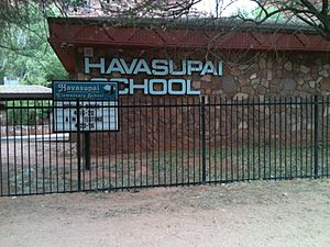
The Havasupai Elementary School is run by the Bureau of Indian Education.
The reservation is part of an "Unorganized School District #00." In Arizona, this means the district does not have a high school.
 | Misty Copeland |
 | Raven Wilkinson |
 | Debra Austin |
 | Aesha Ash |


