
Colorado River Compact facts for kids


The Colorado River Compact is an important agreement made in 1922. It helps decide how the water from the Colorado River is shared among seven U.S. states in the Southwestern United States. These states are in the river's basin, which means the river and its smaller streams flow through them. The agreement was first suggested by a lawyer named Delph Carpenter. It was signed near Santa Fe, New Mexico, by representatives from all seven states.
Contents
What is the Law of the River?
The Colorado River is managed by many rules, laws, and agreements. These include compacts (like the one we're talking about), federal laws, and even an international treaty. All these rules together are known as "the Law of the River." They help make sure the river's water is used fairly.
How the Water is Divided
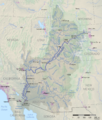
The compact splits the river basin into two main areas:
- Upper Division: This includes Colorado, New Mexico, Utah, and Wyoming.
- Lower Division: This includes Nevada, Arizona, and California.
The agreement says that the Upper Basin states must not use so much water that the flow to the Lower Basin states drops below 75 million acre-feet over any ten-year period. An acre-foot is the amount of water needed to cover one acre of land with water one foot deep. This amount was chosen because people thought it would allow both regions to share the water equally.
This compact was a big deal because it allowed for a lot of irrigation (watering crops) in the Southwest. It also led to the building of huge water projects, like the Hoover Dam and Lake Powell.
Later, in 1928, the exact amounts of water for the Lower Basin states were set. In 1948, the amounts for the Upper Basin states were also decided. Here's how the water is generally divided each year:
| Upper Basin, 7.5 million acre-feet per year total | |||
| Colorado | 51.75%* | 3.86 million acre-feet per year | |
| Utah | 23.00%* | 1.71 million acre-feet per year | |
| Wyoming | 14.00%* | 1.04 million acre-feet per year | |
| New Mexico | 11.25%* | 0.84 million acre-feet per year | |
| Arizona | 0.70% | 0.05 million acre-feet per year | |
| *These percentages are from the total after Arizona's 0.05 million acre-feet are taken out. Arizona's percentage is from the overall total. | |||
| Lower Basin, 7.5 million acre-feet per year total | |||
| California | 58.70% | 4.40 million acre-feet per year | |
| Arizona | 37.30% | 2.80 million acre-feet per year | |
| Nevada | 4.00% | 0.30 million acre-feet per year | |
On top of this, 1.5 million acre-feet of Colorado River water goes to Mexico each year. This is part of a treaty signed in 1944. The Lower Basin states can also get an extra 1.1 million acre-feet of water if there's a lot of surplus water.
The compact was the result of many years of talks. Before the compact, the river's name was made official along its whole length. The part of the river upstream from the Green River was sometimes called the "Grand River." The name change was made official by laws in Colorado and Utah.
One big concern then, and now, was the growing population. More people mean more demand for water, especially in California. More recently, Las Vegas, Nevada, has also been looking for more ways to use Colorado River water.
Early Disputes and Court Cases
The agreement wasn't easy to make, and some states were unhappy. For example, Arizona didn't like its share of water in the Lower Basin. The state refused to sign the agreement for many years, finally doing so in 1944. Arizona even had a big disagreement with California in 1934 over water use, which was eventually settled in court.
Arizona continued to dispute its water share until 1963. The Supreme Court of the United States had to step in with a decision in a case called Arizona v. California. This case lasted 11 years and cost a lot of money. The Court eventually sided with Arizona on some points, helping to clear the way for the Central Arizona Project, a big water delivery system.
Challenges and Future Plans
Since the compact was signed, California has been using any extra water that other states didn't use. But with more people moving to the Southwest, there's worry that this extra water won't be available for California anymore. In 2001, an agreement was made to help California find ways to save water and rely less on the Colorado River over 15 years.
Nevada's growing population is also a concern. Nevada has the smallest water share in the Lower Basin. It might find that the water from the Colorado River isn't enough for its needs in the future. Nevada, like California, might need to focus on saving water and finding other water sources.
The compact was mainly about developing and using the river. But using and reusing the river water, along with building many dams, has hurt native fish and the river's natural environment. Dams block fish, stop natural silt from building up, and change water temperatures. These changes are bad for the ecosystem.
The high water usage has also caused the Colorado River Delta in Mexico to shrink and become dry. This area was once full of life due to silt deposits. The Colorado River's water was actually overestimated when the compact was signed. The river was thought to have 17 million acre-feet a year, but even before recent droughts, it often had much less.
Dealing with Less Water
In recent years, the compact has faced more criticism because there has been less rain and snow in the region. When the compact was made, people thought the river's average flow was about 16.4 million acre-feet per year. However, studies of tree rings (which show past rainfall) suggest the river's long-term average flow is much less, perhaps around 13 to 14 million acre-feet per year. This means the period used to estimate the river's flow (1905–1922) had unusually high rainfall. The recent drought is actually a return to more typical patterns.
This decrease in water has caused water levels in reservoirs, like Lake Powell, to drop a lot. In 2007, new rules were set for how to share Colorado River water during shortages. These rules are temporary until 2026. They help manage Lake Powell and Lake Mead, especially when water levels are low.
The rules describe three levels of shortage based on the water level in Lake Mead:
- Light shortage: If Lake Mead's level is between 1,050 and 1,075 feet, the Lower Basin states get about 7.17 million acre-feet per year.
- Heavy shortage: If Lake Mead's level is between 1,025 and 1,050 feet, they get about 7.08 million acre-feet per year.
- Extreme shortage: If Lake Mead's level drops below 1,025 feet, they get about 7 million acre-feet per year.
In 2008, U.S. Senator John McCain from Arizona suggested that the compact should be looked at again.
Agreement with Mexico: Minute 319
In 2012, the United States and Mexico signed an agreement called "Minute 319." This updated the rules for how Mexico's 1.5 million acre-feet of Colorado River water would be affected by extra water or drought.
- If there's extra water (Lake Mead is high), Mexico gets more water, up to an extra 200,000 acre-feet per year.
- If there's a drought (Lake Mead is low), Mexico's water delivery is reduced. For example, if Lake Mead is below 1,025 feet, Mexico's share is reduced by 125,000 acre-feet.
In 2019, the seven Western states reached a new plan to manage the Colorado River during the ongoing drought.
Images for kids
-

Member states of the Colorado River Compact Upper Division states Lower Division states
-
Map of Colorado River Basin
