March Route of Rochambeau's Army: Hutchinson Road facts for kids
Quick facts for kids |
|
|
March Route of Rochambeau's Army: Hutchinson Road
|
|

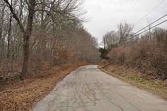
Hutchinson Road in 2016
|
|
| Location | Hutchinson Road, from jct. with Hendee Rd. southward to end, Andover, Connecticut |
|---|---|
| Area | 2 acres (0.81 ha) |
| MPS | Rochambeau's Army in Connecticut, 1780-1782 MPS |
| NRHP reference No. | 02000425 |
| Added to NRHP | May 6, 2002 |
The March Route of Rochambeau's Army: Hutchinson Road is a special historic road in Andover, Connecticut. It's about 2 acres big. This part of Hutchinson Road was built a long time ago, in the early 1700s. It was once part of a bigger road, United States Route 6. This road was super important because it was used by General Rochambeau's army during the American Revolutionary War. Their marches on this road helped America win its independence! This historic road was added to the National Register of Historic Places in 2002.
A Historic Road from the Revolution
Hutchinson Road is located in the western part of Andover. It runs next to the modern US 6 highway. You can get to it from Hendee Road. The historic part of the road is south of Hendee Road. It's paved with asphalt and is about 22 feet wide. Stone walls line most of the road, making it look very old. This special section is about 3000 feet long.
Why Was This Road Important?
This road was first built in the early 1700s. It connected the capital city of Hartford with important towns like Lebanon and Norwich. These towns were in the southeastern part of Connecticut.
French engineers drew maps of this road in 1781. They were planning the route for General Rochambeau's army. This army was helping George Washington and the American forces fight for independence.
Rochambeau's Army Marches Here
During the war, French officers stayed at White's Tavern. This tavern is the only building on this part of Hutchinson Road. They stayed there when the army marched south in 1781. They also stayed there when the army marched north in 1782. The army even set up camp north of Hendee Road during their 1782 march.
Hutchinson Road remained a major route for many years. It was improved in the 1800s and 1900s. Later, a new part of US 6 was built, which bypassed this old section. Even today, the area around Hutchinson Road still looks a lot like it did in the 1780s. It helps us imagine what it was like when the soldiers marched through.
 | Roy Wilkins |
 | John Lewis |
 | Linda Carol Brown |


