Marconi, California facts for kids
Quick facts for kids
Marconi
|
|
|---|---|

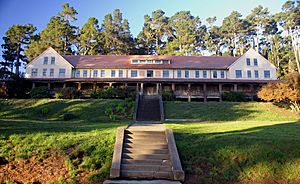
old hotel at the conference center in Marconi
|
|
| Country | United States |
| State | California |
| County | Marin County |
| Elevation | 70 ft (21 m) |
| ZIP code |
94956
|
| Area codes | 415/628 |
| FIPS code | 06-45697 |
| GNIS feature ID | 1659056 |
Marconi (once known as Fisherman's) is a small, special place in Marin County, California. It's an unincorporated community, meaning it's not officially a city or town. You can find it on the northeast shore of Tomales Bay. It's about 7 miles (11 km) south of the village of Tomales. Marconi sits about 70 feet (21 meters) above sea level and is near the town of Marshall, California.
Contents
Discovering Marconi
Marconi has a very interesting past. It has changed from a Native American settlement to a high-tech communication hub, and now it's a state park.
A Glimpse into Marconi's Past
Long ago, Native American people lived here. Their settlement was called "Fisherman's." They would ship seafood from this spot using the railroad.
The Wireless Era
In 1913, a big change happened. The Marconi Wireless Company bought the land. They wanted to build a huge wireless telegraph station here. This station would send messages across the Pacific Ocean without wires!
Later, the United States government took over the site. After some time, it was given to General Electric, a large company.
From Hotel to State Park
In the 1960s, the Marconi site was updated. It became a place where people could stay, like a hotel. However, it soon changed again. A group called Synanon used the facility as a special center to help people.
In the 1980s, the California State Parks system took control of the site. Today, it is known as the Marconi Conference Center State Historic Park. It's a place where groups can hold meetings and events. There are plans to restore the conference center. It might become a working hotel again by late 2024.
 | Laphonza Butler |
 | Daisy Bates |
 | Elizabeth Piper Ensley |


