Margaret Brock Reef facts for kids

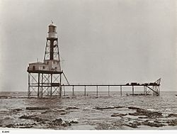
Cape Jaffa Lighthouse (around 1910) on the reef. The top part and keepers' homes were moved in the 1970s.
|
|
| Geography | |
|---|---|
| Location | Limestone Coast, South Australia |
| Coordinates | 36°57′07″S 139°35′44″E / 36.951874°S 139.595642°E |
| Highest elevation | 2 m (7 ft) |
| Administration | |
|
Australia
|
|
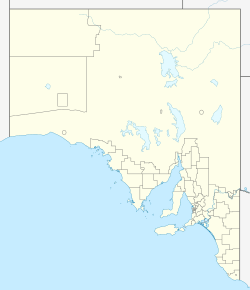
Margaret Brock Reef is a special reef in South Australia. It's found off the south-east coast. The reef is about 7 kilometers (4.3 miles) west of Cape Jaffa. It's also about 27 kilometers (17 miles) southwest of the town of Kingston SE.
This reef is home to an important navigation aid. This aid was a manned lighthouse from 1872 to 1973. Now, it's an automatic beacon. Margaret Brock Reef is also a protected area. It's a sanctuary for rock lobsters. The reef gets its name from a ship called the Margaret Brock. This ship was wrecked there in 1852.
Contents
What is Margaret Brock Reef?
Margaret Brock Reef is located near Cape Jaffa in South Australia. It's about 7 kilometers (4.3 miles) west of the Cape. The reef is also about 27 kilometers (17 miles) southwest of Kingston SE.
The reef sits on the seabed. Some parts of it are above sea level when the tide is low. The shallower parts of the reef stretch for about 5 kilometers (3.1 miles). This is in a north-south direction. The highest part of the reef can stick out 2 meters (6.6 feet) above the water at low tide.
How Margaret Brock Reef Formed
Margaret Brock Reef was created a long time ago. This happened about 6,000 to 7,000 years ago. It formed as the sea level slowly rose. The reef, along with two islands to its south, Baudin Rocks and Penguin Island, are what's left of an old dune system. This system was called the Robe Range.
The reef is made of a crumbly rock. This rock is called Bridgewater Formation calcarenite. It's also known as aeolianite. This type of rock is formed from sand dunes.
The reef can be quite dangerous for ships. This is because some parts are very shallow. Waves might not always break over the reef's edge. This makes it hard for ships to see the danger. Even far from the reef, stormy weather can create big waves.
History of the Reef
Margaret Brock Reef has an interesting history. Many ships have sailed past it. Some have even been wrecked there.
Early Sightings
The reef was first seen by European explorers in April 1802. This was during the Baudin expedition. In 1826, a ship named Sesostris also spotted the reef. The famous ship Margaret Brock was wrecked on the reef in November 1852. After this, a map was made. It showed the reef's location and the wreck site.
How the Reef Got its Name
For many years, the reef was called "Sesostris Reef." This name was used from 1826 until the late 1870s. However, by 1865, people in South Australia started using the name "Margaret Brock Reef." This new name became official in 1879. It honored the ship that was wrecked there.
Ships Wrecked on the Reef
Several ships have been wrecked on Margaret Brock Reef over the years. These include:
- The brigantine Maria in 1840.
- The barque Margaret Brock in 1852.
- The schooner Agnes in 1865.
- The fishing vessel Thunderbird in 1964.
- The fishing vessel Explorer in 1977.
The Cape Jaffa Lighthouse was built right on the reef. It was placed on a part that dries out at low tide. Building started in 1868. The light first shone in January 1872. This lighthouse helped guide ships safely.
In 1973, a new lighthouse was built in Robe. This meant the Cape Jaffa Lighthouse was no longer the main light. In 1975, the top part of the lighthouse was taken apart. This included the lantern room and the keepers' living areas. It was then moved to Kingston SE. There, the National Trust of South Australia rebuilt it. It is now a museum.
The platform left on the reef still helps ships. It now holds an automatic beacon. This beacon is called the Margaret Brock Reef Light.
Protected Area for Lobsters
Margaret Brock Reef is a special sanctuary. It's a place where fishing for southern rock lobster is not allowed. This rule helps protect these important sea creatures. The sanctuary was first set up in 1973. It was created under the state's Fisheries Act 1971. Later, it was re-established under the Fisheries Management Act 2007.
The sanctuary covers an area of 1 kilometer (0.62 miles) around the navigation aid. This is the light on the old lighthouse platform. From 2008 to 2014, this rock lobster sanctuary was listed as a marine protected area. This listing was on the Australian government's database.
 | Chris Smalls |
 | Fred Hampton |
 | Ralph Abernathy |


