Robe, South Australia facts for kids
Quick facts for kids RobeSouth Australia |
|||||||||||||||
|---|---|---|---|---|---|---|---|---|---|---|---|---|---|---|---|

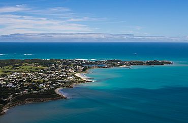
Looking west: the northern area of the town
|
|||||||||||||||
| Population | 1,252 (2021 census) | ||||||||||||||
| Established | 19 March 1846 (town) | ||||||||||||||
| Postcode(s) | 5276 | ||||||||||||||
| Location |
|
||||||||||||||
| LGA(s) | District Council of Robe | ||||||||||||||
| Region | Limestone Coast | ||||||||||||||
| County | County of Robe | ||||||||||||||
| State electorate(s) | MacKillop | ||||||||||||||
| Federal Division(s) | Barker | ||||||||||||||
|
|||||||||||||||
|
|||||||||||||||
Robe is a cool town and fishing port located on the beautiful Limestone Coast in South Australia. It's a popular place for tourists because it has a special mix of old buildings, ocean views, fishing boats, lakes, and thick bushland. Robe is found on the southern shore of Guichen Bay, just off the main Princes Highway. In 2021, about 1252 people lived in Robe. It's the main town in the District Council of Robe local government area. Robe is also part of the state area of MacKillop and the federal Division of Barker.
Robe's Interesting History
Robe is built on the traditional lands of the Buandig and Ngarrindjeri people, who have lived there for a very long time.
European settlers started the town of Robe in 1846. This was ten years after the area of South Australia was first set up. They created Robe to be a busy seaport, a place for government, and a town.
Robe got its name from Major Frederick Robe, who was the fourth Governor of South Australia. He picked this spot for a port in 1845. The town officially became a port in 1847. By the 1850s, Robe was South Australia's second-busiest international port, only after Port Adelaide. Goods like wool, sheep skins, and horses were sent from Robe. Many inns were built along the roads for the bullock teamsters who brought wool from far away, like the Bush Inn which is still there today. The old Customs House, where taxes on goods were collected, has been a protected heritage site since 1980. To help ships find their way safely, a stone tower called an obelisk was built on Cape Dombey in 1852. Even with this, some ships still crashed along the coast. A modern, automatic lighthouse was built on higher ground in 1973.
Around 1857, during the Victorian gold rushes, the government in Victoria added a £10 tax for each person entering. This was a lot of money, more than the cost of their journey! To avoid this tax, over 16,000 Chinese people landed at Robe. From there, they walked about 320 kilometers (200 miles) overland to the goldfields, mostly in places like Ballarat and Bendigo.
Robe's importance as a port lessened when railways were built in the 1800s. These railways went to Kingston (about 40 km north) and Beachport (about 40 km south). Today, Robe is still a service center for the farms around it and is home to a fishing fleet. The rocklobster fishing industry is especially important for the local economy. Did you know that AFL footballer Jordan Dawson, who plays for and captains the Adelaide Crows Football Club, is also from Robe?
Robe's Climate
Robe has a warm-summer Mediterranean climate. This means it has warm, dry summers and mild, rainy winters. The average highest temperature is around 22.6°C in February, and the lowest is about 13.6°C in July. The average lowest temperature at night is about 13.7°C in January and February, and around 8.2°C in July.
On average, Robe gets about 631.6 millimeters (24.9 inches) of rain each year, spread over about 153 days. The town has about 56 clear, sunny days and 163 cloudy days each year. The hottest temperature ever recorded was 39.6°C on February 14, 1981, and the coldest was -2.6°C on July 19, 1982.
There is also a weather station at Robe Airport, which is about 4.6 kilometers (2.9 miles) southeast of the town. This inland station has bigger temperature changes between day and night, and between seasons. It also gets a bit less rain, but it rains more often there.
 | Laphonza Butler |
 | Daisy Bates |
 | Elizabeth Piper Ensley |


