
Marietta Earthworks facts for kids

Drawing of Marietta Earthworks
|
|

Location in Ohio
|
|
| Location | Washington County, Ohio, |
|---|---|
| Region | Washington County, Ohio |
| Coordinates | 39°25′12″N 81°27′7″W / 39.42000°N 81.45194°W |
| History | |
| Founded | 100 BCE |
| Abandoned | 500 CE |
| Cultures | Ohio Hopewell |
| Architecture | |
| Architectural styles | Platform mounds, burial mound, enclosuress, |
The Marietta Earthworks is an amazing ancient site in Ohio, United States. It is located where the Muskingum and Ohio Rivers meet. This special place was built by the ancient Hopewell people. Most of these old earthworks are now covered by the modern city of Marietta. Experts believe the Hopewell people built this ceremonial site between 100 BCE and 500 CE.
Contents
Exploring the Ancient Structures
Early European settlers gave these ancient structures Latin names. The site includes a "sacred way" called Sacra Via. There are also three walled areas, known as enclosures. You can also find the Quadranaou, the Capitolium, and other flat-topped mounds. A large burial mound called the Conus is also part of the complex.
The Capitolium Mound
The Capitolium is a mound shaped like a pyramid with a flat top. It has three ramps that lead up to its summit. This mound is a bit smaller than the Quadranaou mound. Even though it's not in perfect condition, it has been mostly saved. This is because the Washington County Library was built on its top in 1916.
Scientists who study ancient astronomy, called archaeoastronomers, have studied the Capitolium. In the 1990s, William F. Romain found that the mound was built to line up almost perfectly with the winter solstice sunset. This shows how skilled the Hopewell people were.
The Conus Burial Mound
The Conus is a very large burial mound. It is surrounded by a raised bank and a ditch, much like a round barrow. There is a gap in the bank and a dirt ramp across the ditch. This allows access to the base of the mound. When a wall was built outside the ditch, it meant the mound was for ceremonies, not for defense.
Today, the Conus mound stands about 30 feet (9 meters) tall. It is the only part of the earthworks that is still fully intact. The ditch around the mound is 15 feet (4.5 meters) wide and 4 feet (1.2 meters) deep. The bank around it is 20 feet (6 meters) wide at its base. The whole circle around the mound is 585 feet (178 meters) around.
Enclosures and the Sacra Via
The Marietta Earthworks site has three large areas surrounded by earthen walls. The biggest area is about 50 acres. It is a rectangular shape on the northwest side of the complex. From this area, the Sacra Via (sacred way) leads down to the Muskingum River.
Inside this large area were four big flat-topped mounds. The two largest were the Quadranaou in the western corner and the Capitolium on the southeastern side. The two smaller mounds were in the eastern and northern corners.
The Sacra Via was a special path, 680 feet (207 meters) long and 150 feet (45 meters) wide. It started in the middle of the southwest side of the large enclosure. It ended near the Muskingum River. Tall banks, 10 feet (3 meters) high at the enclosure and 20 feet (6 meters) high at the end, lined its sides. Parts of the Sacra Via are now a parkway. Just like the Quadranaou and Capitolium mounds, the Sacra Via was also built to align with the winter solstice sunset.
The second largest enclosure is east of the biggest one. It covers about 27 acres. It had walls about 5 feet (1.5 meters) high with ten gates. Some gates were single openings, but two were double openings. Eight mounds were placed at the gates.
The third and smallest enclosure was made of straight earthen banks. It was located between the second enclosure and the bank around the Conus mound.
The Quadranaou Mound
The Quadranaou was the largest of the flat-topped mounds at the site. It was originally 180 feet (55 meters) long and 32 feet (10 meters) wide. It stood 10 feet (3 meters) tall. This mound had four graded ramps leading to its top. Each ramp was 25 feet (7.6 meters) wide and 60 feet (18 meters) long.
Today, the Quadranaou mound is preserved as "Quadranaou Park." Research from the 1990s showed that this mound was also built to align very precisely with the winter solstice sunset. This again highlights the advanced knowledge of the Hopewell builders.
Modern Discoveries and Preservation
The Marietta Earthworks were first studied in 1786 by Captain Jonathan Hart. He drew a map of the site and explored one of the mounds. His work is believed to be the first archaeological study in Ohio.
Later, in 1788, Rufus Putnam and Reverend Manasseh Cutler also investigated the site. They were surveying the land to found the city of Marietta. Cutler cut down trees growing on the earthworks to count their growth rings. He found that the trees had started growing around 1347. This showed the earthworks were much older than some people thought.
Between 1788 and 1796, a group called the Ohio Company of Associates worked to protect the mounds. They gave them their Latin names and put them under the care of Marietta's future mayor. This helped keep the mounds safe for nearly a century. However, later, some parts were taken apart for building projects.
In 1801, Mound Cemetery was created around the Conus mound. This helped save it from being destroyed. This cemetery is thought to have more graves of American Revolutionary War officers than any other.
In 1838, Samuel Ryan Curtis, a civil engineer, surveyed and drew the complex again. His detailed survey showed the site still had a large square enclosure with four flat-topped mounds. It also had a smaller square and a circular area with the large burial mound in the center.
Sadly, most of the Sacra Via was destroyed in 1882. Its clay was used to make bricks. Many of the earthworks' walls were also taken down for similar construction projects.
The Conus mound was listed on the National Register of Historic Places in 1973. In 1990, archaeologists from the Cleveland Museum of Natural History dug into a part of the Capitolium mound. They confirmed that the Hopewell Culture people definitely built the mound.
Gallery
-
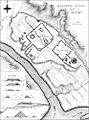
Survey of Marietta Earthworks, 1838
-
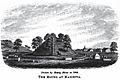
Drawing of Conus in Mound Cemetery, 1846
-
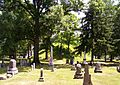
Conus in 2007
-
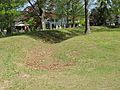
Ditch and embankment around the Conus


