Marionville, Missouri facts for kids
Quick facts for kids
Marionville, Missouri
|
|
|---|---|

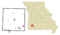
Location of Marionville, Missouri
|
|
| Country | United States |
| State | Missouri |
| County | Lawrence |
| Area | |
| • Total | 1.79 sq mi (4.63 km2) |
| • Land | 1.78 sq mi (4.62 km2) |
| • Water | 0.00 sq mi (0.00 km2) |
| Elevation | 1,365 ft (416 m) |
| Population
(2020)
|
|
| • Total | 2,054 |
| • Density | 1,150.70/sq mi (444.22/km2) |
| Time zone | UTC-6 (Central (CST)) |
| • Summer (DST) | UTC-5 (CDT) |
| ZIP code |
65705
|
| Area code(s) | 417 |
| FIPS code | 29-46172 |
| GNIS feature ID | 0721871 |
Marionville is a small city in Lawrence County, Missouri, in the United States. In 2020, about 2,054 people lived there. Marionville is especially famous for its many white squirrels. These unique animals have been a part of the town for a very long time.
Contents
History of Marionville
Marionville was officially planned and settled in 1854. The city was named after James Marion Moore, an early settler and one of its founders. People sometimes mistakenly think it was named after Francis Marion, a famous general. However, it was truly named to honor James Marion Moore's middle name. Other names like Jamestown or Moorestown were considered, but they were already in use.
A post office opened in Marionville in 1864. On March 12, 2006, a strong tornado hit the town. It caused damage to many buildings.
Famous Residents and Animals
Marionville is known for two special things. One is its group of white squirrels, which have lived in the town since the 1880s. The other is a famous musician named Harvey Phillips, who was known for playing the tuba.
Geography and White Squirrels
Marionville is located in southwestern Missouri. Its exact location is 37°0′1″N 93°38′17″W / 37.00028°N 93.63806°W. The city covers an area of about 1.76 square miles (4.56 square kilometers), and all of it is land.
The White Squirrel Population
One of the most interesting things about Marionville is its large group of white squirrels. These are not albino squirrels, but a special type with white fur. They are quite rare in most places. You can often spot them in yards, especially near the Ozarks Methodist Manor. Marionville is one of only a few places in the United States where you can find so many white squirrels living together.
Population and People
The number of people living in Marionville has changed over the years. Here's how the population has grown and changed since 1870:
| Historical population | |||
|---|---|---|---|
| Census | Pop. | %± | |
| 1870 | 272 | — | |
| 1880 | 432 | 58.8% | |
| 1890 | 1,159 | 168.3% | |
| 1900 | 1,290 | 11.3% | |
| 1910 | 1,272 | −1.4% | |
| 1920 | 1,167 | −8.3% | |
| 1930 | 1,227 | 5.1% | |
| 1940 | 1,127 | −8.1% | |
| 1950 | 1,167 | 3.5% | |
| 1960 | 1,251 | 7.2% | |
| 1970 | 1,496 | 19.6% | |
| 1980 | 1,920 | 28.3% | |
| 1990 | 1,920 | 0.0% | |
| 2000 | 2,113 | 10.1% | |
| 2010 | 2,225 | 5.3% | |
| 2020 | 2,054 | −7.7% | |
| U.S. Decennial Census | |||
Life in Marionville
In 2010, there were 2,225 people living in Marionville. There were 900 households, which are groups of people living in one home. Many families lived there, including married couples and single-parent households.
About a quarter of the people were under 18 years old. The average age in the city was around 40.5 years. More than half of the residents were female.
Education in Marionville
The Marionville R-IX School District is in charge of the schools in the city. It includes:
- One elementary school for younger students.
- One middle school for older elementary students.
- Marionville High School for teenagers.
Marionville also has a public library. It is a part of the Barry-Lawrence Regional Library system. This library provides books and resources for everyone in the community.
See also
 In Spanish: Marionville (Misuri) para niños
 | Kyle Baker |
 | Joseph Yoakum |
 | Laura Wheeler Waring |
 | Henry Ossawa Tanner |

